
Súbor:Bessarabia.png

Pôvodný súbor (544 × 607 pixelov, veľkosť súboru: 49 KB, MIME typ: image/png)
Zhrnutie
| Popis |
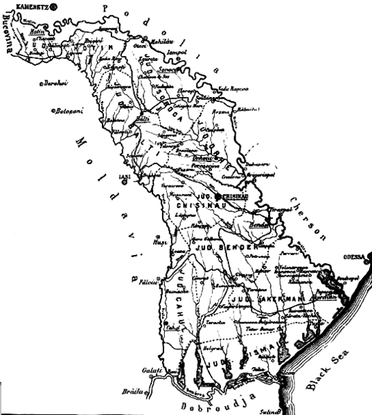
English: The map of the region of Bessarabia (1812-1917) Română: Harta Basarabiei Русский: Карта Бессарабии |
| Dátum | |
| Zdroj | http://depts.washington.edu/cartah/text_archive/clark/b_22.jpg |
| Autor | Celeron |
Licencovanie
|
Toto dílo je volné také v zemích, jejichž právní řád chrání majetková autorská práva po dobu života autora a 70 let po jeho smrti.
| |
| Tento súbor bol identifikovaný, že nemá žiadne známe obmedzenia vyplývajúce z autorského zákona vrátane všetkých súvisiacich a susedných práv. | |
Comment 1
better version of map at 
Comment 2
This map is from the book "Bessarabia, Russia, and Roumania on the Black Sea" by Charles Upson Clark.
An electronic version of the book is available online: http://depts.washington.edu/cartah/text_archive/clark/meta_pag.shtml
História súboru
Po kliknutí na dátum/čas uvidíte ako súbor vyzeral vtedy.
| Dátum/Čas | Náhľad | Rozmery | Používateľ | Komentár | |
|---|---|---|---|---|---|
| aktuálna | 20:52, 19. máj 2006 | | 544 × 607 (49 KB) | Zserghei | This image was copied from wikipedia:en. The original description was: {{PD}} ==Comment 1== better version of map at Image:Bessarabia.jpg ==Comment 2== This map is from the book "Bessarabia, Russia, and Roumania on the Black Sea" by Charles Upson C |
| 00:47, 3. október 2005 |  | 544 × 607 (49 KB) | Celeron | {{pd}} bessarabia's map |
Použitie súboru
Žiadne stránky neobsahujú odkazy na tento súbor.
Globálne využitie súborov
Nasledovné ďalšie wiki používajú tento súbor:
- Použitie na ar.wikipedia.org
- Použitie na ast.wikipedia.org
- Použitie na beta.wikiversity.org
- Použitie na ca.wikipedia.org
- Použitie na cs.wikipedia.org
- Použitie na dsb.wikipedia.org
- Použitie na en.wikipedia.org
- Použitie na es.wikipedia.org
- Použitie na eu.wikipedia.org
- Použitie na id.wikipedia.org
- Použitie na is.wikipedia.org
- Použitie na it.wikipedia.org
- Použitie na ko.wikipedia.org
- Použitie na mk.wikipedia.org
- Použitie na ms.wikipedia.org
- Použitie na nl.wikipedia.org
- Použitie na no.wikipedia.org
- Použitie na pl.wikipedia.org
- Použitie na pnb.wikipedia.org
- Použitie na ro.wikipedia.org
- Použitie na sl.wikipedia.org
- Použitie na sq.wikipedia.org
- Použitie na sv.wikipedia.org
- Použitie na tr.wikipedia.org
- Použitie na uk.wikipedia.org
- Použitie na ur.wikipedia.org
- Použitie na vi.wikipedia.org
- Použitie na zh.wikipedia.org