
Súbor:French India 1741-1754.png

Veľkosť tohto náhľadu: 486 × 599 pixelov. Iné rozlíšenia: 195 × 240 pixelov | 389 × 480 pixelov | 623 × 768 pixelov | 1 044 × 1 287 pixelov .
Pôvodný súbor (1 044 × 1 287 pixelov, veľkosť súboru: 200 KB, MIME typ: image/png)
Zhrnutie
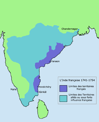
French control and influence in India 1741-1754, based on information from [1]. Map is not neutral: it does not show areas of British control and influence depicted on source map, some of which overlap the French areas.
![[1]](https://homepages.rootsweb.com/~poyntz/India/images/india_shepherd_1923.jpg)
Licencovanie
Ja, držiteľ autorských práv k tomuto dielu ho týmto zverejňujem za podmienok nasledovnej licencie:

|
Bolo udelené povolenie kopírovať, širiť a/alebo meniť tento dokument za podmienok GNU Free Documentation License, verzie 1.2 alebo ktorejkoľvek neskoršej verzie publikovanej Free Software Foundation; bez Nemenných častí, bez Textov na prednej obálke a bez Textov na zadnej obálke. Kópia tejto licencie je zahrnutá v časti nazvanej GNU Free Documentation License. |
| Tento súbor podlieha licencii Creative Commons Attribution-Share Alike 3.0 Unported | ||
| ||
| Táto šablóna licencie bola pridaná k tomuto súboru počas aktualizácie licencovania GFDL. |
História súboru
Po kliknutí na dátum/čas uvidíte ako súbor vyzeral vtedy.
| Dátum/Čas | Náhľad | Rozmery | Používateľ | Komentár | |
|---|---|---|---|---|---|
| aktuálna | 13:33, 18. marec 2011 | | 1 044 × 1 287 (200 KB) | Hypersite | L'ancienne version de la carte n'était pas correcte, j'en est donc fait une nouvelle respectant plus les données de l'époque avec des ajout de territoires dans l'est et des réduction dans l'ouest, j'ai utiliser pour model plusieurs données dont une c |
| 13:03, 13. máj 2006 |  | 1 044 × 1 287 (46 KB) | Roke~commonswiki | French control and influence in India 1741-1754, based on information from [http://homepages.rootsweb.com/~poyntz/India/images/india_shepherd_1923.jpg] Category: Historical maps of India |
Použitie súboru
Na tento súbor odkazuje nasledujúca stránka:
Globálne využitie súborov
Nasledovné ďalšie wiki používajú tento súbor:
- Použitie na af.wikipedia.org
- Použitie na ar.wikipedia.org
- Použitie na az.wikipedia.org
- Použitie na ba.wikipedia.org
- Použitie na bg.wikipedia.org
- Použitie na bn.wikipedia.org
- Použitie na cs.wikipedia.org
- Použitie na de.wikipedia.org
- Použitie na en.wikipedia.org
- Použitie na eo.wikipedia.org
- Použitie na es.wikipedia.org
- Použitie na eu.wikipedia.org
- Použitie na fa.wikipedia.org
- Použitie na fr.wikipedia.org
- Použitie na he.wikipedia.org
- Použitie na hi.wikipedia.org
- Použitie na hu.wikipedia.org
- Použitie na hy.wikipedia.org
- Použitie na id.wikipedia.org
- Použitie na it.wikipedia.org
- Použitie na ja.wikipedia.org
- Použitie na li.wikipedia.org
- Použitie na lv.wikipedia.org
- Použitie na nl.wikipedia.org
- Použitie na nn.wikipedia.org
- Použitie na pl.wikipedia.org
Zobraziť ďalšie globálne použitie tohto súboru.