
Súbor:Hellas MOLA zoom 64 small.jpg

Veľkosť tohto náhľadu: 672 × 600 pixelov. Iné rozlíšenia: 269 × 240 pixelov | 538 × 480 pixelov | 860 × 768 pixelov | 1 147 × 1 024 pixelov | 2 294 × 2 048 pixelov | 5 600 × 5 000 pixelov .
Pôvodný súbor (5 600 × 5 000 pixelov, veľkosť súboru: 10,03 MB, MIME typ: image/jpeg)
Zhrnutie
| Popis |
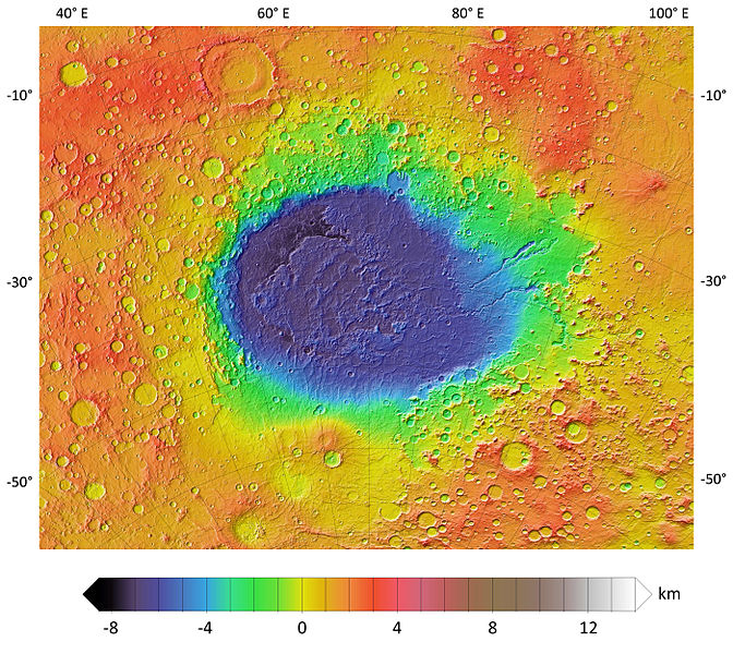
English: A colorized topographic map of the martian impact basin Hellas, together with its surroundings, from the Mars Orbiter Laser Altimeter (MOLA) instrument of the Mars Global Surveyor spacecraft. Hellas, the deepest basin on Mars, lies in the southern hemisphere, south of Syrtis Major Planum. |
| Dátum | |
| Zdroj | JMARS |
| Autor | NASA / JPL-Caltech / Arizona State University |
| Ďalšie verzie |
|


Licencovanie
| This file is in the public domain in the United States because it was solely created by NASA. NASA copyright policy states that "NASA material is not protected by copyright unless noted". (See Template:PD-USGov, NASA copyright policy page or JPL Image Use Policy.) | ||
 |
Warnings:
|
História súboru
Po kliknutí na dátum/čas uvidíte ako súbor vyzeral vtedy.
| Dátum/Čas | Náhľad | Rozmery | Používateľ | Komentár | |
|---|---|---|---|---|---|
| aktuálna | 23:16, 1. december 2013 | | 5 600 × 5 000 (10,03 MB) | WolfmanSF | User created page with UploadWizard |
Použitie súboru
Na tento súbor odkazuje nasledujúca stránka:
Globálne využitie súborov
Nasledovné ďalšie wiki používajú tento súbor:
- Použitie na ca.wikipedia.org
- Použitie na eo.wikipedia.org
- Použitie na es.wikipedia.org
- Použitie na fi.wikipedia.org
- Použitie na it.wikipedia.org
- Použitie na nl.wikipedia.org
- Použitie na pl.wikipedia.org
- Použitie na pt.wikipedia.org
- Použitie na zh.wikipedia.org