
Súbor:Moravske.slezsko.png

Veľkosť tohto náhľadu: 800 × 594 pixelov. Iné rozlíšenia: 320 × 237 pixelov | 640 × 475 pixelov | 1 024 × 760 pixelov | 1 108 × 822 pixelov .
Pôvodný súbor (1 108 × 822 pixelov, veľkosť súboru: 172 KB, MIME typ: image/png)
Zhrnutie
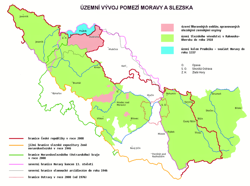
| Popis | Map showing the historical development of border between Moravia and Silesia, borders of the Silesian subdivision (Slezská expozitura) within the Moravian-Silesian Land (Země Moravskoslezská) of Czechoslovakia, borders of the Moravian-Silesian Region of the Czech Republic, borders of the Duchy of Silesia of Austria-Hungary and borders of the City of Ostrava. Red line shows the border of the Czech Republic in 2008. Yellow line shows the southern border of the Silesian subdivision within the Moravian-Silesian Land of Czechoslovakia. Green line shows the border of the Moravian-Silesian Region (Moravskoslezský kraj) of the Czech Republic. Pink line shows the northern border of Moravia at the end of the 13th century. Grey line shows the northern border of the Olomouc Archdiocese. Dotted line shows the border of the City of Ostrava in 2008. The area in green shows the former Duchy of Silesia (the Austrian Silesia). The area in blue shows land around Prudnik, which was a part of Moravia until 1337. The descriptions are in Czech. |
| Dátum | |
| Zdroj | Vlastné dielo |
| Autor | Amic, corrected by Kirk |
| Povolenie (Využívanie tohto súboru) |
Public Domain |
Licencovanie
| Ja, držiteľ autorských práv k tomuto dielu, uvoľňujem toto dielo ako voľné dielo (public domain). Toto platí celosvetovo. V niektorých krajinách to zákon neumožňuje; v tom prípade: Udeľujem komukoľvek právo používať toto dielo na ľubovoľné účely, bez akýchkoľvek podmienok ak také podmienky nevyžaduje zákon. |
História súboru
Po kliknutí na dátum/čas uvidíte ako súbor vyzeral vtedy.
| Dátum/Čas | Náhľad | Rozmery | Používateľ | Komentár | |
|---|---|---|---|---|---|
| aktuálna | 17:31, 9. máj 2021 | | 1 108 × 822 (172 KB) | ElCet | Prudník |
| 12:48, 3. november 2010 |  | 1 108 × 822 (194 KB) | Kostěj | second attempt | |
| 12:45, 3. november 2010 |  | 1 108 × 822 (194 KB) | Kostěj | description correction (the file is used on or comes from the Moravian movement webpages (for example, here: http://zamoravu.eu/mno-k-morave/slezsko/), who consider the Czech Silesia (or at least most of its territory) to be part of Moravia, which is a PO | |
| 12:16, 27. október 2010 |  | 1 108 × 822 (59 KB) | Kirk979 | correction | |
| 16:18, 2. august 2009 |  | 1 108 × 822 (194 KB) | STS Chvojkovice-Brod | přesnější popis | |
| 22:55, 3. júl 2008 |  | 1 108 × 822 (59 KB) | Kirk979 | {{Information |Description= |Source= |Date= |Author= |Permission= |other_versions= }} | |
| 22:52, 3. júl 2008 |  | 1 108 × 822 (59 KB) | Kirk979 | {{Information |Description= |Source= |Date= |Author= |Permission= |other_versions= }} | |
| 16:02, 3. júl 2008 |  | 1 108 × 822 (59 KB) | Kirk979 | {{Information |Description= |Source= |Date= |Author= |Permission= |other_versions= }} | |
| 08:41, 18. máj 2008 |  | 1 108 × 822 (56 KB) | Amic~commonswiki | {{Information |Description=The historical development of Moravian (or Czech or also Austrian) Silesia. Description in Czech language. |Source=own work |Date=18.5.2008 |Author=Amic |Permission=Public Domain |other_versions=none }} [[Category:Maps_of_the_Cz |
Použitie súboru
Na tento súbor odkazuje nasledujúca stránka:
Globálne využitie súborov
Nasledovné ďalšie wiki používajú tento súbor:
- Použitie na cs.wikipedia.org
- Použitie na pl.wikipedia.org