
Súbor:Mount Mazama eruption timeline.PNG
Pôvodný súbor (250 × 841 pixelov, veľkosť súboru: 187 KB, MIME typ: image/png)
Zhrnutie
| Popis |
|
| Zdroj | http://pubs.usgs.gov/fs/2002/fs092-02/ (saved as PNG) |
| Autor | U.S. GEOLOGICAL SURVEY and the NATIONAL PARK SERVICE |
| Ďalšie verzie |
    |

|
Tento obrázek (skupina geology) by měl být vytvořen pomocí vektorové grafiky jako SVG soubor. To má několik výhod; podrobnosti najdete na stránce Commons:Media for cleanup. Je-li SVG verze tohoto obrázku již k dispozici, prosím nahrajte ji. Po nahrání nahraďte tuto šablonu šablonou {{Vector version available|jméno nového obrázku.svg}}.
|
Licencovanie
Tento soubor je volné dílo, protože obsahuje materiály pocházející od United States Geological Survey (USGS), agentury Ministerstva vnitra USA. Pro bližší informaci vizte oficiální licenční pravidla USGS (anglicky).
|
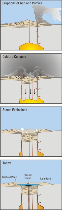
Crater Lake is an example, it is located in Oregen and was made from a valcano, making a caldera.
História súboru
Po kliknutí na dátum/čas uvidíte ako súbor vyzeral vtedy.
| Dátum/Čas | Náhľad | Rozmery | Používateľ | Komentár | |
|---|---|---|---|---|---|
| aktuálna | 05:24, 29. marec 2006 | 250 × 841 (187 KB) | Jkelly | Source: http://pubs.usgs.gov/fs/2002/fs092-02/ (saved as PNG) Author: U.S. GEOLOGICAL SURVEY and the NATIONAL PARK SERVICE Description: <blockquote>Cataclysmic eruption to present. Eruptions of ash and pumice: The cataclysmic eruption started from a ve |
Použitie súboru
Na tento súbor odkazuje nasledujúca stránka:
Globálne využitie súborov
Nasledovné ďalšie wiki používajú tento súbor:
- Použitie na af.wikipedia.org
- Použitie na an.wikipedia.org
- Použitie na ar.wikipedia.org
- Použitie na ast.wikipedia.org
- Použitie na br.wikipedia.org
- Použitie na ce.wikipedia.org
- Použitie na cy.wikipedia.org
- Použitie na de.wikipedia.org
- Použitie na en.wikipedia.org
- Použitie na en.wikiversity.org
- Použitie na eo.wikipedia.org
- Použitie na es.wikipedia.org
- Použitie na fa.wikipedia.org
- Použitie na fi.wikipedia.org
- Použitie na fr.wikipedia.org
- Použitie na id.wikipedia.org
- Použitie na it.wikipedia.org
- Použitie na ja.wikipedia.org
- Použitie na ko.wikipedia.org
- Použitie na lv.wikipedia.org
- Použitie na min.wikipedia.org
- Použitie na mk.wikipedia.org
- Použitie na ml.wikipedia.org
- Použitie na pt.wikipedia.org
- Použitie na ru.wikipedia.org
- Použitie na simple.wikipedia.org
- Použitie na sr.wikipedia.org
- Použitie na su.wikipedia.org
- Použitie na vi.wikipedia.org
- Použitie na www.wikidata.org