
Súbor:PIA02820.jpg

Veľkosť tohto náhľadu: 800 × 554 pixelov. Iné rozlíšenia: 320 × 222 pixelov | 640 × 443 pixelov | 1 024 × 709 pixelov | 1 280 × 886 pixelov | 2 560 × 1 772 pixelov | 4 000 × 2 769 pixelov .
Pôvodný súbor (4 000 × 2 769 pixelov, veľkosť súboru: 1,06 MB, MIME typ: image/jpeg)
Zhrnutie
| Popis |
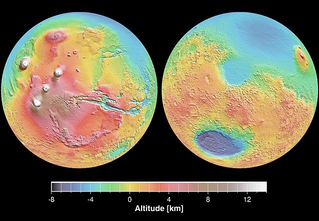
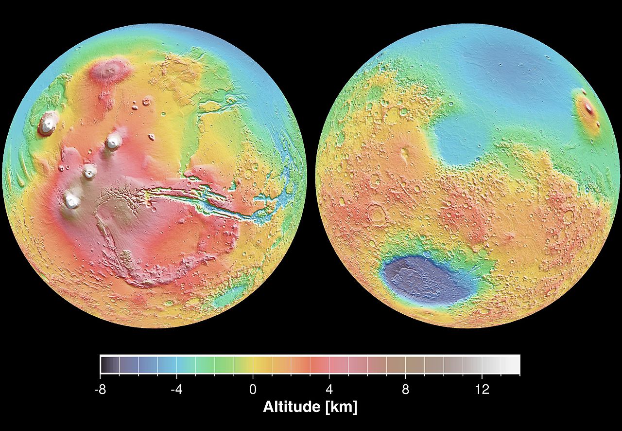
English: These maps are global false-color topographic views of Mars at different orientations from the Mars Orbiter Laser Altimeter (MOLA). The maps are orthographic projections that contain over 200,000,000 points and about 5,000,000 altimetric crossovers. The spatial resolution is about 15 kilometers at the equator and less at higher latitudes. The vertical accuracy is less than 5 meters. The right hand image view features the Hellas impact basin (in purple, with red annulus of high standing material). The left hand features the Tharsis topographic rise (in red and white). Note also the subtle textures associated with resurfacing of the northern hemisphere lowlands in the vicinity of the Utopia impact basin. This data was compiled by the Mars Orbiter Laser Altimeter (MOLA) Team, led by David Smith at the Goddard Space Flight Center in Greenbelt, MD.
Español: Levantamento topográfico realizado pela sonda norte-americana Mars Global Surveyor |
| Dátum | |
| Zdroj | http://photojournal.jpl.nasa.gov/catalog/PIA02820 |
| Autor | NASA/JPL |
Tento mediální soubor byl katalogizován v Jet Propulsion Laboratory amerického Národního úřadu pro letectví a kosmonautiku (NASA)pod Photo ID: PIA02820. Toto oznámení nepopisuje autorskoprávní status tohoto souboru. Stále je vyžadován běžný popisek licence. Další informace najdete na Commons:Licencování. Jiné jazyky:
|
Licencovanie
| This file is in the public domain in the United States because it was solely created by NASA. NASA copyright policy states that "NASA material is not protected by copyright unless noted". (See Template:PD-USGov, NASA copyright policy page or JPL Image Use Policy.) | ||
 |
Warnings:
|
História súboru
Po kliknutí na dátum/čas uvidíte ako súbor vyzeral vtedy.
| Dátum/Čas | Náhľad | Rozmery | Používateľ | Komentár | |
|---|---|---|---|---|---|
| aktuálna | 19:23, 29. december 2005 | | 4 000 × 2 769 (1,06 MB) | Severino666~commonswiki | Levantamento topográfico realizado pela sonda norte-americana Mars Global Surveyor Category:Mars |
Použitie súboru
Na tento súbor odkazuje nasledujúca stránka:
Globálne využitie súborov
Nasledovné ďalšie wiki používajú tento súbor:
- Použitie na ca.wikipedia.org
- Použitie na cs.wikipedia.org
- Použitie na en.wikipedia.org
- Použitie na en.wikibooks.org
- Použitie na en.wikiversity.org
- Použitie na es.wikipedia.org
- Použitie na fi.wikipedia.org
- Použitie na fr.wikipedia.org
- Použitie na it.wikipedia.org
- Použitie na ja.wikipedia.org
- Použitie na mk.wikipedia.org
- Použitie na ml.wikipedia.org
- Použitie na nap.wikipedia.org
- Použitie na no.wikipedia.org
- Použitie na olo.wikipedia.org
- Použitie na pt.wikipedia.org
- Použitie na pt.wikibooks.org
- Použitie na ro.wikipedia.org
- Použitie na ru.wikipedia.org
- Použitie na sv.wikipedia.org
- Použitie na zh.wikipedia.org