
Súbor:World map of countries by ecological footprint (2007).svg

Veľkosť tohoto PNG náhľadu tohoto SVG súboru: 800 × 353 pixelov. Iné rozlíšenia: 320 × 141 pixelov | 640 × 283 pixelov | 1 024 × 452 pixelov | 1 280 × 565 pixelov | 2 560 × 1 130 pixelov | 940 × 415 pixelov .
Pôvodný súbor (SVG súbor, 940 × 415 pixelov, veľkosť súboru: 1,36 MB)
Zhrnutie
| Popis |
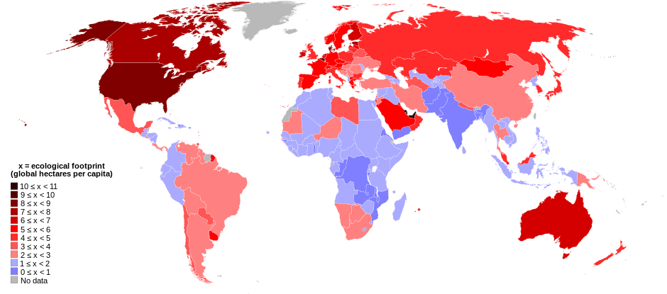
English: World map of countries shaded according to their ecological footprint in 2007 (published on 13 October 2010 by the Global Footprint Network). It is measured by the amount of global hectares that are affected by humans per capita of the country. Lighter shades denote countries with a lower ecological footprint per capita and darker shaded for countries with a higher ecological footprint per capita. The total ecological footprint (global hectares affected by humans) is measured as a total of six factors: cropland footprint, grazing footprint, forest footprint, fishing ground footprint, carbon footprint and built-up land.
Français : Mapemonde colorée selon l'empreinte écologique moyenne des habitants de chaque pays, exprimée en ha par personne, en 2007. Le tons plus chairs correspondent à une empreinte faible, les tons plus sombres à une empreinte plus forte. Six facteurs sont pris en compte pour mesurer cette empreinte: L'agriculture, le pâturage, l'exploitation forestière, la pêche, la production de carbone et l'urbanisation.
No data
0 ≤ x < 1
1 ≤ x < 2
2 ≤ x < 3
3 ≤ x < 4
4 ≤ x < 5
5 ≤ x < 6
6 ≤ x < 1
7 ≤ x < 8
8 ≤ x < 9
9 ≤ x < 10
10 ≤ x < 11 |
| Dátum | |
| Zdroj | Self-made with data from list of countries by ecological footprint. |
| Autor | Jolly Janner |
| Ďalšie verzie |
|


.svg)
Licencovanie
| Ja, držiteľ autorských práv k tomuto dielu, uvoľňujem toto dielo ako voľné dielo (public domain). Toto platí celosvetovo. V niektorých krajinách to zákon neumožňuje; v tom prípade: Udeľujem komukoľvek právo používať toto dielo na ľubovoľné účely, bez akýchkoľvek podmienok ak také podmienky nevyžaduje zákon. |
História súboru
Po kliknutí na dátum/čas uvidíte ako súbor vyzeral vtedy.
| Dátum/Čas | Náhľad | Rozmery | Používateľ | Komentár | |
|---|---|---|---|---|---|
| aktuálna | 01:24, 30. marec 2018 | | 940 × 415 (1,36 MB) | Sisgeo | Employ a different color for countries under 2.1 gHa, the estimated limit of sustainability. |
| 18:44, 29. október 2010 |  | 940 × 415 (1,68 MB) | Jolly Janner | Added a white box to represent the background | |
| 18:38, 29. október 2010 |  | 940 × 415 (1,68 MB) | Jolly Janner | white background | |
| 18:36, 29. október 2010 |  | 940 × 415 (1,68 MB) | Jolly Janner | white background | |
| 18:24, 29. október 2010 |  | 940 × 415 (1,68 MB) | Jolly Janner | == {{int:filedesc}} == {{Information |Description={{en|1=World map of countries shaded according to their ecological footprint in 2007 (published on 13 October 2010 by the Global Footprint Network). It is measured by the amoun |
Použitie súboru
Na tento súbor odkazuje nasledujúca stránka:
Globálne využitie súborov
Nasledovné ďalšie wiki používajú tento súbor:
- Použitie na ca.wikipedia.org
- Použitie na el.wikipedia.org
- Použitie na en.wikipedia.org
- Použitie na en.wikibooks.org
- Použitie na eu.wikipedia.org
- Použitie na fa.wikipedia.org
- Použitie na fr.wikipedia.org
- Použitie na gl.wikipedia.org
- Použitie na hi.wikipedia.org
- Použitie na it.wikipedia.org
- Použitie na ms.wikipedia.org
- Použitie na nl.wikipedia.org
- Použitie na pl.wikipedia.org
- Použitie na pl.wikibooks.org
- Použitie na ro.wikipedia.org
- Použitie na sr.wikipedia.org
- Použitie na ta.wikipedia.org
- Použitie na uk.wikipedia.org
- Použitie na zh.wikipedia.org
.svg)