
Súbor:France 1154-fr.svg

Veľkosť tohoto PNG náhľadu tohoto SVG súboru: 503 × 600 pixelov. Iné rozlíšenia: 201 × 240 pixelov | 403 × 480 pixelov | 644 × 768 pixelov | 859 × 1 024 pixelov | 1 718 × 2 048 pixelov | 1 405 × 1 675 pixelov .
Pôvodný súbor (SVG súbor, 1 405 × 1 675 pixelov, veľkosť súboru: 529 KB)
Zhrnutie
| Popis |
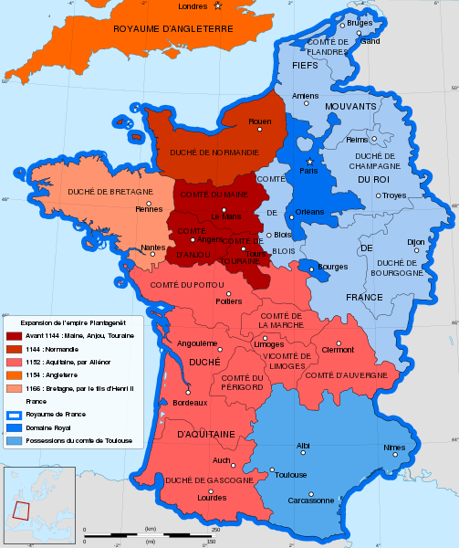
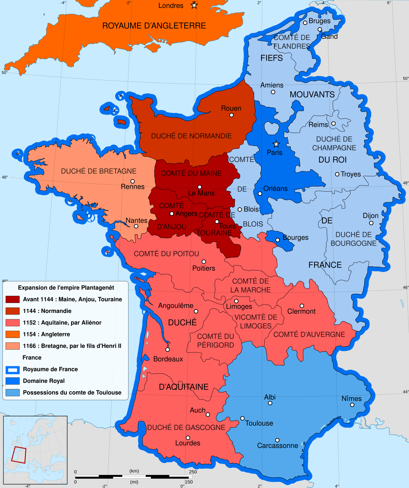
English: French map of the growth of the Plantagenet Empire, from 1144 to 1166.
Français : Carte en français de l'expansion de l'empire Plantagenêt, de 1144 à 1166. |
||
| Dátum | |||
| Zdroj |
Vlastné dielo. Sources :
|
||
| Autor | Sémhur | ||
| Ďalšie verzie |
[]
| ||
| Uvedenie autora (vyžadované licenciou) | © Sémhur / Wikimedia Commons / | ||
| SVG | W3C-validity not checked. Táto W3C-nešpecifikovaná vektorová grafika bola vytvorená pomocou Inkscape .
|
||
| Atelier graphique |


| Pozícia kamery | | Tento a ďalšie obrázky na: OpenStreetMap |
|---|
Licencovanie
Ja, držiteľ autorských práv k tomuto dielu ho týmto zverejňujem za podmienok nasledovných licencií:
| Copyleft: Toto výtvarné dielo je slobodné; môžete ho šíriť a/alebo meniť za podmienok Free Art License. Exemplár tejto licencie nájdete na stránke Copyleft Attitude a na ďalších stránkach. |
This file is licensed under the Creative Commons Attribution-Share Alike Attribution-Share Alike 4.0 International, 3.0 Unported, 2.5 Generic, 2.0 Generic and 1.0 Generic license.
- Môžete slobodne:
- zdieľať – kopírovať, šíriť a prenášať dielo
- meniť ho – upravovať dielo
- Za nasledovných podmienok:
- uvedenie autorov – Musíte spomenúť autorov (jednotlivo alebo kolektívne), poskytnúť odkaz na licenciu a uviesť, či ste niečo zmenili. Môžete to urobiť ľubovoľným primeraným spôsobom, ale nie spôsobom naznačujúcim, že poskytovateľ licencie podporuje vás alebo vaše použitie diela.
- meniť za rovnakých podmienok – Ak toto dielo zmeníte, prevediete do inej formy alebo použijete ako základ iného diela, musíte výsledok šíriť pod rovnakou alebo kompatibilnou licenciou ako originál.
Môžete si zvoliť ľubovolnú z týchto licencií.
História súboru
Po kliknutí na dátum/čas uvidíte ako súbor vyzeral vtedy.
| Dátum/Čas | Náhľad | Rozmery | Používateľ | Komentár | |
|---|---|---|---|---|---|
| aktuálna | 14:59, 21. máj 2021 | | 1 405 × 1 675 (529 KB) | YaouhPower | Correction orthographe Angoulême |
| 11:31, 12. júl 2013 |  | 1 405 × 1 675 (542 KB) | Citypeek | Corrected two mistakes in code. Valid SVG now. | |
| 08:53, 27. január 2012 |  | 1 405 × 1 675 (542 KB) | Sémhur | Few mistakes in legend | |
| 11:44, 27. júl 2009 |  | 1 405 × 1 675 (678 KB) | Sémhur | == {{int:filedesc}} == {{Information |Description= {{en|French map of the growth of the Plantagenet Empire, from 1144 to 1166.}} {{fr|Carte en français de l'expansion de l'empire Plantagenêt, de 1144 à 1166.}} |Source={{own}}. Sources : * [[:Image:Fran |
Použitie súboru
Na tento súbor odkazuje nasledujúca stránka:
Globálne využitie súborov
Nasledovné ďalšie wiki používajú tento súbor:
- Použitie na be.wikipedia.org
- Použitie na en.wikipedia.org
- Použitie na es.wikipedia.org
- Použitie na eu.wikipedia.org
- Použitie na fr.wikipedia.org
- 1154
- Henri II (roi d'Angleterre)
- Comté de Poitou
- Aliénor d'Aquitaine
- Histoire de l'Aquitaine
- Discussion:Cartographie/Archive01
- Comté de Touraine
- Maison de Laval
- Empire Plantagenêt
- Foulques V d'Anjou
- Duché d'Aquitaine
- Histoire des grandes puissances
- Histoire de l'Anjou
- Comté de Blois
- Discussion:Cartographie
- Discussion:La Rochelle/Archives 1
- Liste des comtesses et duchesses d'Anjou
- Hugues le Brun
- Liste des maîtres de la province d'Auvergne de l'ordre du Temple
- Použitie na lt.wikipedia.org
- Použitie na pt.wikipedia.org
- Použitie na ro.wikipedia.org
- Použitie na sl.wikipedia.org
- Použitie na uk.wikipedia.org