
Súbor:Gulf of Taranto map.png

Veľkosť tohto náhľadu: 545 × 600 pixelov. Iné rozlíšenia: 218 × 240 pixelov | 436 × 480 pixelov | 698 × 768 pixelov | 1 200 × 1 321 pixelov .
Pôvodný súbor (1 200 × 1 321 pixelov, veľkosť súboru: 348 KB, MIME typ: image/png)
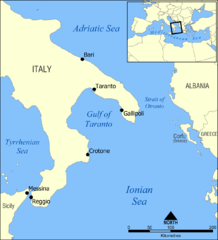
A map showing the location of the Gulf of Taranto in the Mediterranean sea, south of Italy.
Created by NormanEinstein, March 28, 2006.
Ja, držiteľ autorských práv k tomuto dielu ho týmto zverejňujem za podmienok nasledovnej licencie:

|
Bolo udelené povolenie kopírovať, širiť a/alebo meniť tento dokument za podmienok GNU Free Documentation License, verzie 1.2 alebo ktorejkoľvek neskoršej verzie publikovanej Free Software Foundation; bez Nemenných častí, bez Textov na prednej obálke a bez Textov na zadnej obálke. Kópia tejto licencie je zahrnutá v časti nazvanej GNU Free Documentation License. |
| Tento súbor podlieha licencii Creative Commons Attribution-Share Alike 3.0 Unported | ||
| ||
| Táto šablóna licencie bola pridaná k tomuto súboru počas aktualizácie licencovania GFDL. |
Other versions
- Croatian: File:Gulf of Taranto map hr.svg
História súboru
Po kliknutí na dátum/čas uvidíte ako súbor vyzeral vtedy.
| Dátum/Čas | Náhľad | Rozmery | Používateľ | Komentár | |
|---|---|---|---|---|---|
| aktuálna | 14:35, 3. jún 2009 | | 1 200 × 1 321 (348 KB) | Rhegion | added Reggio |
| 18:53, 28. marec 2006 |  | 1 200 × 1 321 (409 KB) | NormanEinstein | A map showing the location of the Gulf of Taranto in the Mediterranean sea, south of Italy. Created by NormanEinstein, March 28, 2006. {{GFDL-self}} |
Použitie súboru
Na tento súbor odkazuje nasledujúca stránka:
Globálne využitie súborov
Nasledovné ďalšie wiki používajú tento súbor:
- Použitie na ar.wikipedia.org
- Použitie na az.wikipedia.org
- Použitie na ba.wikipedia.org
- Použitie na be-tarask.wikipedia.org
- Použitie na be.wikipedia.org
- Použitie na br.wikipedia.org
- Použitie na bs.wikipedia.org
- Použitie na ckb.wikipedia.org
- Použitie na cs.wikipedia.org
- Použitie na da.wikipedia.org
- Použitie na de.wikipedia.org
- Použitie na de.wikibooks.org
- Použitie na el.wikipedia.org
- Použitie na en.wikipedia.org
- Tegetthoff-class battleship
- SMS Szent István
- Gulf of Taranto
- SMS Prinz Eugen (1912)
- User:NormanEinstein/gallery
- Adriatic campaign of 1807–1814
- Wikipedia:Graphics Lab/Map workshop/Archive/Feb 2012
- SMS Saida
- Yugoslav torpedo boat T4
- Novara-class cruiser
- SMS Tegetthoff (1912)
- SMS Admiral Spaun
- SMS Orjen
- Použitie na eo.wikipedia.org
- Použitie na es.wikipedia.org
- Použitie na eu.wikipedia.org
- Použitie na ext.wikipedia.org
- Použitie na fa.wikipedia.org
- Použitie na fi.wikipedia.org
- Použitie na fo.wikipedia.org
- Použitie na fr.wikipedia.org
- Použitie na gl.wikipedia.org
Zobraziť ďalšie globálne použitie tohto súboru.