
Súbor:Polish-Lithuanian Commonwealth in 1772.PNG
Veľkosť tohto náhľadu: 732 × 600 pixelov. Iné rozlíšenia: 293 × 240 pixelov | 586 × 480 pixelov | 937 × 768 pixelov | 1 250 × 1 024 pixelov | 1 894 × 1 552 pixelov .
Pôvodný súbor (1 894 × 1 552 pixelov, veľkosť súboru: 747 KB, MIME typ: image/png)
Zhrnutie
| Popis |
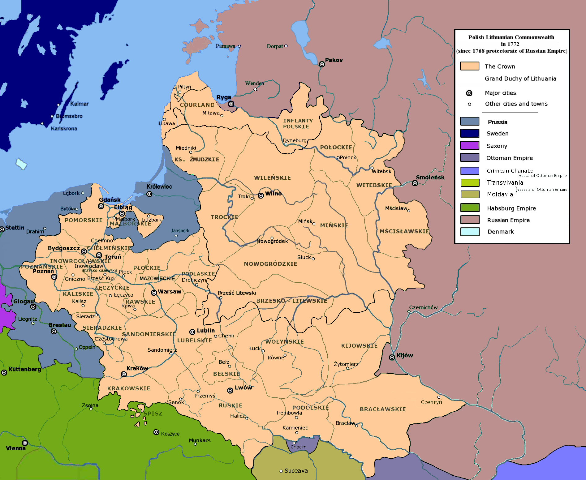
English: Polish-Lithuanian Commonwealth in 1772 |
| Dátum | |
| Zdroj | Vlastné dielo |
| Autor | User:Mathiasrex Maciej Szczepańczyk, based on layers of User:Halibutt |
Licencovanie
Ja, držiteľ autorských práv k tomuto dielu ho týmto zverejňujem za podmienok nasledovných licencií:

|
Bolo udelené povolenie kopírovať, širiť a/alebo meniť tento dokument za podmienok GNU Free Documentation License, verzie 1.2 alebo ktorejkoľvek neskoršej verzie publikovanej Free Software Foundation; bez Nemenných častí, bez Textov na prednej obálke a bez Textov na zadnej obálke. Kópia tejto licencie je zahrnutá v časti nazvanej GNU Free Documentation License. |
Tento súbor podlieha licencii Creative Commons Attribution-Share Alike 3.0 Unported
- Môžete slobodne:
- zdieľať – kopírovať, šíriť a prenášať dielo
- meniť ho – upravovať dielo
- Za nasledovných podmienok:
- uvedenie autorov – Musíte spomenúť autorov (jednotlivo alebo kolektívne), poskytnúť odkaz na licenciu a uviesť, či ste niečo zmenili. Môžete to urobiť ľubovoľným primeraným spôsobom, ale nie spôsobom naznačujúcim, že poskytovateľ licencie podporuje vás alebo vaše použitie diela.
- meniť za rovnakých podmienok – Ak toto dielo zmeníte, prevediete do inej formy alebo použijete ako základ iného diela, musíte výsledok šíriť pod rovnakou alebo kompatibilnou licenciou ako originál.
Môžete si zvoliť ľubovolnú z týchto licencií.
História súboru
Po kliknutí na dátum/čas uvidíte ako súbor vyzeral vtedy.
| Dátum/Čas | Náhľad | Rozmery | Používateľ | Komentár | |
|---|---|---|---|---|---|
| aktuálna | 09:35, 23. júl 2020 | | 1 894 × 1 552 (747 KB) | Claude Zygiel | Tak: nie "województwa Kozackiego", a południe dobrze reprezentowane. :-) |
| 18:11, 18. jún 2020 |  | 1 900 × 1 554 (735 KB) | Poznaniak | Reverted to version as of 05:53, 26 June 2018 (UTC) kuriozum, nie było żadnego województwa "kozackiego" | |
| 18:28, 13. apríl 2020 |  | 1 894 × 1 552 (751 KB) | Claude Zygiel | Some details since Stier, H.E. (ed.) ''Grosser Atlas zur Weltgeschichte'', Westermann 1985, {{ISBN|3-14-100919-8}}, ''Putzger historischer Weltatlas'', Cornelsen 1990, {{ISBN|3-464-00176-8}}, Sellier, A.J. (ed.) « Atlas des Peuples » -''Europe centrale'', 1992, {{ISBN|2-7071-2032-4}} La Découverte publ., {{ISBN|2-7071-2222-X}}, Unger, M. (ed.) ''Történelmi atlasz'', Hungarian academy 1991, {{ISBN|963-351-422-3}}. | |
| 05:53, 26. jún 2018 |  | 1 900 × 1 554 (735 KB) | Mathiasrex | new version | |
| 05:51, 26. jún 2018 |  | 1 900 × 1 554 (742 KB) | Mathiasrex | new version | |
| 04:59, 15. marec 2018 |  | 1 900 × 1 554 (793 KB) | Poeticbent | Reverted to version as of 17:27, 4 May 2017 (UTC) - accessibility for people with color vision impairment | |
| 19:08, 12. marec 2018 |  | 1 992 × 1 554 (797 KB) | Mathiasrex | Reverted to version as of 09:39, 1 February 2017 (UTC) light green as Russian protectorate | |
| 17:27, 4. máj 2017 |  | 1 900 × 1 554 (793 KB) | Maproom | Removed Habsburg-green pixels from Poland. Renamed "Russia" to "Russian Empire" | |
| 15:33, 2. marec 2017 |  | 1 902 × 1 554 (822 KB) | Poeticbent | en:Talk:Partitions of Poland - accessibility for people with color vision impairment | |
| 09:39, 1. február 2017 |  | 1 992 × 1 554 (797 KB) | Mathiasrex | Reverted to version as of 22:48, 3 November 2011 (UTC) |
Použitie súboru
Na tento súbor odkazuje nasledujúca stránka:
Globálne využitie súborov
Nasledovné ďalšie wiki používajú tento súbor:
- Použitie na de.wikipedia.org
- Použitie na el.wikipedia.org
- Použitie na en.wikipedia.org
- Partitions of Poland
- Talk:Partitions of Poland
- Ambassadors and envoys from Russia to Poland (1763–1794)
- Austrian Partition
- Prussian Partition
- Russian Partition
- Talk:Former eastern territories of Germany/Archive 5
- Wikipedia:Graphics Lab/Map workshop/Archive/2017/Jun 2017
- User:Falcaorib/Poland-Lithuania
- Použitie na es.wikipedia.org
- Použitie na fr.wikipedia.org
- Použitie na ga.wikipedia.org
- Použitie na it.wikipedia.org
- Použitie na lt.wikipedia.org
- Použitie na lt.wikibooks.org
- Použitie na pl.wikipedia.org
- Použitie na pl.wikivoyage.org
- Použitie na pnb.wikipedia.org
- Použitie na ro.wikipedia.org
- Použitie na simple.wikipedia.org
- Použitie na sr.wikipedia.org
- Použitie na th.wikipedia.org
- Použitie na tr.wikipedia.org
- Použitie na uk.wikipedia.org
- Použitie na ur.wikipedia.org
- Použitie na vi.wikipedia.org