
Súbor:Карта УСРР, 1931 рік.JPG

Veľkosť tohto náhľadu: 800 × 566 pixelov. Iné rozlíšenia: 320 × 226 pixelov | 640 × 453 pixelov | 1 024 × 724 pixelov | 1 280 × 905 pixelov | 2 765 × 1 956 pixelov .
Pôvodný súbor (2 765 × 1 956 pixelov, veľkosť súboru: 1,2 MB, MIME typ: image/jpeg)
Zhrnutie
| Popis |
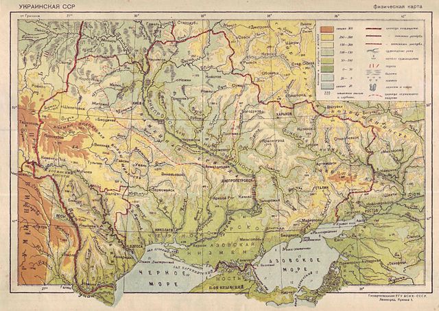
Українська: Карта Української РСР, 1931 English: Map of the Ukrainian SSR, 1931 Français : Carte de la RSS d'Ukraine, 1931 |
| Dátum | |
| Zdroj | Малая Советская Энциклопедия. Том девятый. Тугендбунд—Шверник. — М.: Государственное словарно-энциклопедическое издательство "Советская Энциклопедия" — ОГИЗ РСФСР, 1931.— |
| Autor | Neznámý |
Licencovanie
This file is a Ukrainian or Ukrainian SSR work and it is presently in the public domain in Ukraine, because it was published before January 1, 1954, and the creator (if known) died before that date (details).
|
 |
História súboru
Po kliknutí na dátum/čas uvidíte ako súbor vyzeral vtedy.
| Dátum/Čas | Náhľad | Rozmery | Používateľ | Komentár | |
|---|---|---|---|---|---|
| aktuálna | 22:43, 17. december 2013 | | 2 765 × 1 956 (1,2 MB) | Ejensyd | User created page with UploadWizard |
Použitie súboru
Na tento súbor odkazuje nasledujúca stránka:
Globálne využitie súborov
Nasledovné ďalšie wiki používajú tento súbor:
- Použitie na be-tarask.wikipedia.org
- Použitie na pl.wikipedia.org
- Použitie na uk.wikipedia.org