Súbor:Europe 1914.jpg
Obsah stránky není podporován v jiných jazycích.
z Wikipédie, slobodnej encyklopédie

Pôvodný súbor(1 198 × 863 pixelov, veľkosť súboru: 110 KB, MIME typ: image/jpeg)

Tento zdieľaný súbor je z Wikimedia Commons a je možné ho používať na iných projektoch. Nižšie sú zobrazené informácie z popisnej stránky súboru.

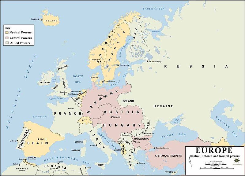
Popis European alliances during the 1914-18 war. Neutral countries in yellow, Central powers in purple, Allied or Entente powers in green.
Zdroj www.dean.usma.edu
Autor Department of History, United States Military Academy
Ďalšie verzie
Maps of the history of Europe
BCE
aC

Weichselian ice age (c. 113,000–9700) · Neolithic expansion (c. 7000–4500) · Middle Neolithic (c. 4500–4000) · Late Neolithic (c. 4000–3000) · Copper Age – Corded Ware culture (c. 2900–2350) · Copper Age – Bellbeaker culture (c. 2800–1800) · Early Bronze Age – Unetice culture (c. 2300–1600) · Late Bronze Age – Urnfield culture (c. 1300—750) · Migrations (c. 1000–100) · Hallstatt & La Tène cultures (c. 800–100) · Roman Republic (510–40) · 220 · 218 · 200 · 201–100 · 58 · 49 · 39 · 30 BCE–6 CE


CE
dC

14 · 14–37 · 60 · 60 · 69 · 80 · Migrations 100–500 · 117 · 117 · 125 · Migrations 150–774 · Economy 180 · 271 · 293–305 · 337 · 395 · c. 395 · 400 · 400 · 450 · 457–61 · 476 · 480 · Franks 481–814 · Early Slavs 500–700 · 500 · 526 · 526–600 · Christianisation to 600 · c. 550 · 650 · Pontic Steppe 650 · 665 · 800 · Vikings 800–1050 · 814 · 843–70 · 850 · 900 · 912 · 998 · 1000 · 1000 · 1054 · 1092 · First Crusade 1095–99 · 1097 · 1135 · 1142 · 1147–49 · 1190 · 1190 · 1250 · c. 1250 · 1301-1400 · 1301-1400 · 1328 · 1345 · Black Plague 1347–51 · 1360 · 1400 · Trade routes c. 1400 · 1430 · 1470 · 1490 · 1492 · 1500 · 1519 · 1550 · 1560 · Religion 1560 · Religion 1600 · Religion 1618 · 1618–48 · 1648 · 1683 · 1700 · 1701 · 1708 · 1714 · 1721 · 1725–30 · 1739–1740 · 1740 · 1748–66 · 1783–1792 · 1787 · 1787 · 1789 · 1799 · 1812 · 1812 · 1812 · 1812 · 1813 · 1815 · 1815 · 1815 · 1818 · Ottoman Empire 1830–1923 · 1848–49 · 1861 · 1867 · 1871 · 1878 · 1890 · 1905 · 1911 · 1914 · 1914 · 1919 · 1919–29 · 1923 · 1929 · 1930 · 1940 · 1941–42 · 1942–45 · Cold War 1947–91 · 1950 · 1993–2006 · 2006 to date

(this template: · view · discuss )
  • Background information:

In 1938 the predecessors of what is today The Department of History at the United States Military Academy began developing a series of campaign atlases to aid in teaching cadets a course entitled, "History of the Military Art." Since then, the Department has produced over six atlases and more than one thousand maps, encompassing not only America’s wars but global conflicts as well.

In keeping abreast with today's technology, the Department of History is providing these maps on the internet as part of the department's outreach program. The maps were created by the United States Military Academy’s Department of History and are the digital versions from the atlases printed by the United States Defense Printing Agency. We gratefully acknowledge the accomplishments of the department's former cartographer, Mr. Edward J. Krasnoborski, along with the works of our present cartographer, Mr. Frank Martini.

Please be aware that these maps are large in file size and may require substantial download times.


Public domain
Tento obrázek nebo soubor je dílem zaměstnance Armády Spojených států amerických pořízeným nebo vytvořeným během výkonu oficiálních povinností. Jako dílo federální vlády USA je tento obrázek nebo soubor volným dílem.

العربية  বাংলা  català  čeština  Deutsch  English  español  eesti  فارسی  suomi  français  hrvatski  magyar  Bahasa Indonesia  italiano  日本語  한국어  lietuvių  македонски  മലയാളം  မြန်မာဘာသာ  Nederlands  polski  português  русский  sicilianu  српски / srpski  Türkçe  українська  Tiếng Việt  中文(简体)  中文(繁體)  +/−

Štítky

Pridajte jednoriadkové vysvetlenie, čo tento súbor predstavuje
European alliances during World War I, 1914–1918

Položky prezentované týmto súborom

motív

image/jpeg

História súboru

Po kliknutí na dátum/čas uvidíte ako súbor vyzeral vtedy.

Dátum/ČasNáhľadRozmeryPoužívateľKomentár
aktuálna18:50, 18. február 2011Náhľad verzie z 18:50, 18. február 20111 198 × 863 (110 KB)DrKayremove "Bosina"; correct spelling of "GIBRALTAR" and "Nicosia"
08:20, 18. február 2011Náhľad verzie z 08:20, 18. február 20111 198 × 863 (110 KB)DrKaychange color of Albania; remove "Bosina"; change "Turkey" to "Ottoman Empire"
18:55, 17. február 2011Náhľad verzie z 18:55, 17. február 20111 198 × 863 (111 KB)DrKaychange color of Luxembourg and Persia; remove "1914" replace with "Central, Entente and Neutral powers"
19:44, 24. júl 2008Náhľad verzie z 19:44, 24. júl 20081 198 × 863 (136 KB)Wereonadded missing "ENGLAND" to map
09:29, 1. marec 2006Náhľad verzie z 09:29, 1. marec 20061 198 × 863 (140 KB)W.wolny

Na tento súbor odkazuje nasledujúca stránka:

Globálne využitie súborov

Nasledovné ďalšie wiki používajú tento súbor:

Zobraziť ďalšie globálne použitie tohto súboru.

Metadáta