
Súbor:Hammurabi's Babylonia Locator Map 1.svg

Veľkosť tohoto PNG náhľadu tohoto SVG súboru: 671 × 600 pixelov. Iné rozlíšenia: 269 × 240 pixelov | 537 × 480 pixelov | 859 × 768 pixelov | 1 146 × 1 024 pixelov | 2 291 × 2 048 pixelov | 744 × 665 pixelov .
Pôvodný súbor (SVG súbor, 744 × 665 pixelov, veľkosť súboru: 154 KB)
Zhrnutie
| Popis |
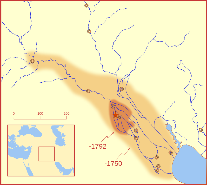
A locator map of Hammurabi's Babylonia, showing the Babylonian territory upon his ascension in 1792 BC and upon his death in 1750 BC. The river courses and coastline are those of that time period -- in general, they are not the modern rivers or coastlines. This is a Mercator projection, with north in its usual position. There is some question to what degree the cities of Nineveh, Tuttul, and Assur were under Babylonian authority. While in his introduction to his code of laws, Hammurabi claims lordship over these cities, Roaf does not include any of these in his map, upon which this map is based, and Chevalas states that "Assur and Nineveh were held for a very few years" (p. 155). Therefore, I have not included them as under Hammurabi's control in 1750 BC. |
| Dátum | |
| Zdroj | Vlastné dielo |
| Autor | MapMaster |
| Ďalšie verzie |
[]
|


Other versions
References
- Bjorklund, Oddvar; Holmboe, Haakon; Rohr, Anders (1970) Historical Atlas of the World, Barnes & Noble, NY, SBN: 389-00253-4.
- Chavalas, Mark W.; K. Lawson Younger (2003) Mesopotamia and the Bible, Continuum International Publishing Group, ISBN 978-0567082312.
- Hammond World Atlas Corporation (2007) Historical World Atlas, ISBN 9-780843-71391-6
- Roaf, M. (1990) Cultural Atlas of Mesopotamia and the ancient Near East, Oxford: Facts on File. (In general, the basis for the ancient river courses and ancient coastline).
- Van De Mieroop, Marc (2005). King Hammurabi of Babylon: A Biography. Blackwell Publishing. ISBN 1405126604
Licencovanie
Ja, držiteľ autorských práv k tomuto dielu ho týmto zverejňujem za podmienok nasledovných licencií:

|
Bolo udelené povolenie kopírovať, širiť a/alebo meniť tento dokument za podmienok GNU Free Documentation License, verzie 1.2 alebo ktorejkoľvek neskoršej verzie publikovanej Free Software Foundation; bez Nemenných častí, bez Textov na prednej obálke a bez Textov na zadnej obálke. Kópia tejto licencie je zahrnutá v časti nazvanej GNU Free Documentation License. |
This file is licensed under the Creative Commons Attribution-Share Alike 4.0 International, 3.0 Unported, 2.5 Generic, 2.0 Generic and 1.0 Generic license.
- Môžete slobodne:
- zdieľať – kopírovať, šíriť a prenášať dielo
- meniť ho – upravovať dielo
- Za nasledovných podmienok:
- uvedenie autorov – Musíte spomenúť autorov (jednotlivo alebo kolektívne), poskytnúť odkaz na licenciu a uviesť, či ste niečo zmenili. Môžete to urobiť ľubovoľným primeraným spôsobom, ale nie spôsobom naznačujúcim, že poskytovateľ licencie podporuje vás alebo vaše použitie diela.
- meniť za rovnakých podmienok – Ak toto dielo zmeníte, prevediete do inej formy alebo použijete ako základ iného diela, musíte výsledok šíriť pod rovnakou alebo kompatibilnou licenciou ako originál.
Môžete si zvoliť ľubovolnú z týchto licencií.
História súboru
Po kliknutí na dátum/čas uvidíte ako súbor vyzeral vtedy.
| Dátum/Čas | Náhľad | Rozmery | Používateľ | Komentár | |
|---|---|---|---|---|---|
| aktuálna | 03:26, 21. február 2008 | | 744 × 665 (154 KB) | MapMaster | "blurred" the territory outlines |
| 23:22, 20. február 2008 |  | 744 × 665 (149 KB) | MapMaster | Changes based on a review of ''Mesopotamia and the Bible'' | |
| 22:10, 20. február 2008 |  | 744 × 665 (151 KB) | MapMaster | Minor edits | |
| 03:03, 19. február 2008 |  | 744 × 665 (150 KB) | MapMaster | Once more, with feeling | |
| 02:09, 19. február 2008 |  | 744 × 665 (151 KB) | MapMaster | earlier upload would not render | |
| 02:01, 19. február 2008 |  | 332 × 292 (333 KB) | MapMaster | {{Information |Description=A locator map of Hammurabi's Babylonia, showing the Babylonian territory upon his ascension in 1792 BC and upon his death in 1750 BC. The river courses and coastline are those of that time period -- in general, they are not the |
Použitie súboru
Žiadne stránky neobsahujú odkazy na tento súbor.
Globálne využitie súborov
Nasledovné ďalšie wiki používajú tento súbor:
- Použitie na bg.wikipedia.org
- Použitie na bs.wikipedia.org
- Použitie na cs.wikipedia.org
- Použitie na da.wikipedia.org
- Použitie na el.wikipedia.org
- Použitie na eo.wikipedia.org
- Použitie na et.wikipedia.org
- Použitie na fi.wikipedia.org
- Použitie na fr.wikipedia.org
- Použitie na gl.wikipedia.org
- Použitie na he.wikipedia.org
- Použitie na hr.wikipedia.org
- Použitie na hu.wikipedia.org
- Použitie na id.wikipedia.org
- Použitie na it.wikipedia.org
- Použitie na ja.wikipedia.org
- Použitie na jv.wikipedia.org
- Použitie na lt.wikipedia.org
- Použitie na lv.wikipedia.org
- Použitie na nl.wikipedia.org
- Použitie na no.wikipedia.org
- Použitie na pl.wikipedia.org
- Použitie na pt.wikipedia.org
- Použitie na ro.wikipedia.org
- Použitie na ru.wikipedia.org
- Použitie na sh.wikipedia.org
- Použitie na sl.wikipedia.org
- Použitie na sq.wikipedia.org
- Použitie na sv.wikipedia.org
- Použitie na sw.wikipedia.org
- Použitie na tr.wikipedia.org