
Súbor:Piri Reis map of Europe and the Mediterranean Sea.jpg

Pôvodný súbor (2 000 × 1 375 pixelov, veľkosť súboru: 510 KB, MIME typ: image/jpeg)
Zhrnutie
| Popis |
العربية: نسخة عن خريطة تعود لِأواخر القرن السادس عشر الميلادي، منقولة عن الأصل المُنتجة سنة 1525م والمُدرجة ضمن كتاب البحريَّة من تأليف پيري ريِّس
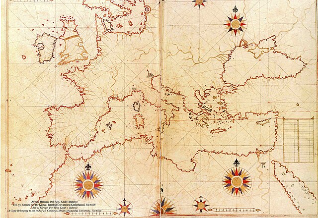
English: a late 16th century copy of the 1525 Kitab-ı Bahriye (Book of Navigation) by Piri Reis |
||||||||||||||||||||
| Dátum | late 16th century (Original upload date on en:wikipedia by Flavius Belisarius, 13 August 2007) | ||||||||||||||||||||
| Zdroj | Library of Istanbul University. No:6605 | ||||||||||||||||||||
| Autor |
|
||||||||||||||||||||

|
Derivate Works

Licencovanie
|
Toto dílo je volné také v zemích, jejichž právní řád chrání majetková autorská práva po dobu života autora a 70 let po jeho smrti.
| |
| Tento súbor bol identifikovaný, že nemá žiadne známe obmedzenia vyplývajúce z autorského zákona vrátane všetkých súvisiacich a susedných práv. | |
História súboru
Po kliknutí na dátum/čas uvidíte ako súbor vyzeral vtedy.
| Dátum/Čas | Náhľad | Rozmery | Používateľ | Komentár | |
|---|---|---|---|---|---|
| aktuálna | 20:12, 5. august 2008 | | 2 000 × 1 375 (510 KB) | Xauxa | {{Information |Description=Piri Reis map of Europe, the Mediterranean Sea and North Africa from his Kitab-ı Bahriye (Book of Navigation), 1521-1525 |Source=en:Piri Reis map of Europe and the Mediterranean Sea.jpg |Date=drawn 1513, uploaded on en:wik |
Použitie súboru
Na tento súbor odkazuje nasledujúca stránka:
Globálne využitie súborov
Nasledovné ďalšie wiki používajú tento súbor:
- Použitie na ar.wikipedia.org
- بوابة:الدولة العثمانية/صورة
- بوابة:جغرافيا/صورة مختارة/أرشيف
- ويكيبيديا:صور مختارة/رسومات وجداول وخرائط/خرائط
- بيري ريس
- ويكيبيديا:ترشيحات الصور المختارة/خريطة حوض المتوسط لبيري ريس
- ويكيبيديا:صورة اليوم المختارة/سبتمبر 2018
- قالب:صورة اليوم المختارة/2018-09-04
- بوابة:الدولة العثمانية/صورة مختارة/47
- بوابة:جغرافيا/صورة مختارة/14
- ويكيبيديا:صورة اليوم المختارة/يناير 2022
- قالب:صورة اليوم المختارة/2022-01-14
- البرازيل (جزيرة أسطورية)
- Použitie na azb.wikipedia.org
- Použitie na az.wikipedia.org
- Použitie na cs.wikipedia.org
- Použitie na de.wikipedia.org
- Použitie na el.wikipedia.org
- Použitie na en.wikipedia.org
- Použitie na es.wikipedia.org
- Použitie na ga.wikipedia.org
- Použitie na hr.wikipedia.org
- Použitie na id.wikipedia.org
- Použitie na ja.wikipedia.org
- Použitie na nl.wikipedia.org
- Použitie na no.wikipedia.org
- Použitie na pl.wikipedia.org
- Použitie na pt.wikipedia.org
- Použitie na ro.wikipedia.org
- Použitie na sh.wikipedia.org
- Použitie na sr.wikipedia.org
- Použitie na sv.wikipedia.org
- Použitie na tk.wikipedia.org
Zobraziť ďalšie globálne použitie tohto súboru.