
Súbor:Plan Centre Spatial Guyanais-en.svg

Veľkosť tohoto PNG náhľadu tohoto SVG súboru: 648 × 599 pixelov. Iné rozlíšenia: 260 × 240 pixelov | 519 × 480 pixelov | 831 × 768 pixelov | 1 108 × 1 024 pixelov | 2 215 × 2 048 pixelov | 1 060 × 980 pixelov .
Pôvodný súbor (SVG súbor, 1 060 × 980 pixelov, veľkosť súboru: 472 KB)

|
This SVG file contains embedded text that can be translated into your language, using any capable SVG editor, text editor or the SVG Translate tool. For more information see: About translating SVG files. |
Zhrnutie
| Popis |
[]
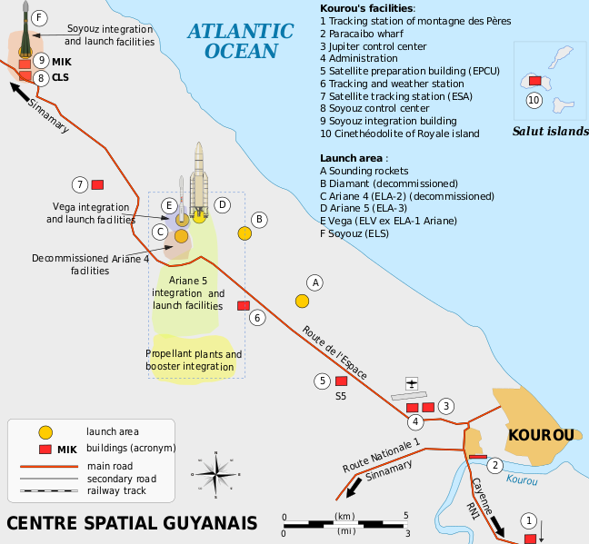
Català: Mapa de la infraestructura dels llançadors Ariane i Vega al port espacial europeu (Centre Spatial Guyanais o CSG), Kourou, Guaiana Francesa Deutsch: Karte der Infrastruktur der Ariana- und Vega-Startrampen auf dem Weltraumbahnhof Kourou, Französisch-Guayana English: Map of the infrastructure for the Ariane and Vega launchers at the Europe's Spaceport (Centre Spatial Guyanais or CSG) , Kourou, French Guiana Français : Carte des installations du Centre Spatial Guyanais (CSG) de Kourou, Guyane Francaise (France) Magyar: A Guyanai Űrközpont térképe Nederlands: Kaart van de Europese lanceerbasis (Centre Spatial Guyanais of CSG) in Kourou, Frans Guiana Русский: План космодрома «Куру» во Французской Гвиане |
||
| Dátum | |||
| Zdroj | Vlastné dielo | ||
| Autor | Pline | ||
| Ďalšie verzie |
[]
|


Licencovanie
Ja, držiteľ autorských práv k tomuto dielu ho týmto zverejňujem za podmienok nasledovných licencií:

|
Bolo udelené povolenie kopírovať, širiť a/alebo meniť tento dokument za podmienok GNU Free Documentation License, verzie 1.2 alebo ktorejkoľvek neskoršej verzie publikovanej Free Software Foundation; bez Nemenných častí, bez Textov na prednej obálke a bez Textov na zadnej obálke. Kópia tejto licencie je zahrnutá v časti nazvanej GNU Free Documentation License. |
Tento súbor je licencovaný za podmienok Creative Commons Attribution-Share Alike 3.0 Unported, 2.5 Generic, 2.0 Generic a 1.0 Generic.
- Môžete slobodne:
- zdieľať – kopírovať, šíriť a prenášať dielo
- meniť ho – upravovať dielo
- Za nasledovných podmienok:
- uvedenie autorov – Musíte spomenúť autorov (jednotlivo alebo kolektívne), poskytnúť odkaz na licenciu a uviesť, či ste niečo zmenili. Môžete to urobiť ľubovoľným primeraným spôsobom, ale nie spôsobom naznačujúcim, že poskytovateľ licencie podporuje vás alebo vaše použitie diela.
- meniť za rovnakých podmienok – Ak toto dielo zmeníte, prevediete do inej formy alebo použijete ako základ iného diela, musíte výsledok šíriť pod rovnakou alebo kompatibilnou licenciou ako originál.
Môžete si zvoliť ľubovolnú z týchto licencií.
História súboru
Po kliknutí na dátum/čas uvidíte ako súbor vyzeral vtedy.
| Dátum/Čas | Náhľad | Rozmery | Používateľ | Komentár | |
|---|---|---|---|---|---|
| aktuálna | 18:08, 4. marec 2016 | | 1 060 × 980 (472 KB) | Manlleus | Sorry again! |
| 18:06, 4. marec 2016 |  | 1 060 × 980 (524 KB) | Manlleus | Reverted to version as of 13:37, 13 April 2009 (UTC) - Sorry, was a big error! | |
| 20:51, 1. február 2016 |  | 1 060 × 980 (524 KB) | Manlleus | Editing SVG source code using User:Rillke/SVGedit.js; upload handled by User:Rillke/MwJSBot.js | |
| 13:37, 13. apríl 2009 |  | 1 060 × 980 (524 KB) | Pline | {{Information |Description={{en|1=Map of the infrastructure for the Ariane and Vega launchers at the Europe's Spaceport (Centre Spatial Guyanais or CSG) , Kourou, French Guiana}} {{fr|1=Carte des installations du Centre Spatial Guyanais (CSG) de Kourou, G |
Použitie súboru
Na tento súbor odkazuje nasledujúca stránka:
Globálne využitie súborov
Nasledovné ďalšie wiki používajú tento súbor:
- Použitie na el.wikipedia.org
- Použitie na en.wikipedia.org
- Použitie na eo.wikipedia.org
- Použitie na es.wikipedia.org
- Použitie na et.wikipedia.org
- Použitie na fi.wikipedia.org
- Použitie na he.wikipedia.org
- Použitie na id.wikipedia.org
- Použitie na it.wikipedia.org
- Použitie na ja.wikipedia.org
- Použitie na kn.wikipedia.org
- Použitie na lv.wikipedia.org
- Použitie na ms.wikipedia.org
- Použitie na no.wikipedia.org
- Použitie na ro.wikipedia.org
- Použitie na sl.wikipedia.org
- Použitie na sr.wikipedia.org
- Použitie na uk.wikipedia.org
- Použitie na vi.wikipedia.org
- Použitie na zh.wikipedia.org