
Súbor:ReichskommissariatUkraineMap.png
Veľkosť tohto náhľadu: 765 × 600 pixelov. Iné rozlíšenia: 306 × 240 pixelov | 612 × 480 pixelov | 980 × 768 pixelov | 1 280 × 1 004 pixelov | 2 560 × 2 007 pixelov | 3 000 × 2 352 pixelov .
Pôvodný súbor (3 000 × 2 352 pixelov, veľkosť súboru: 1,36 MB, MIME typ: image/png)
Zhrnutie
| Popis |
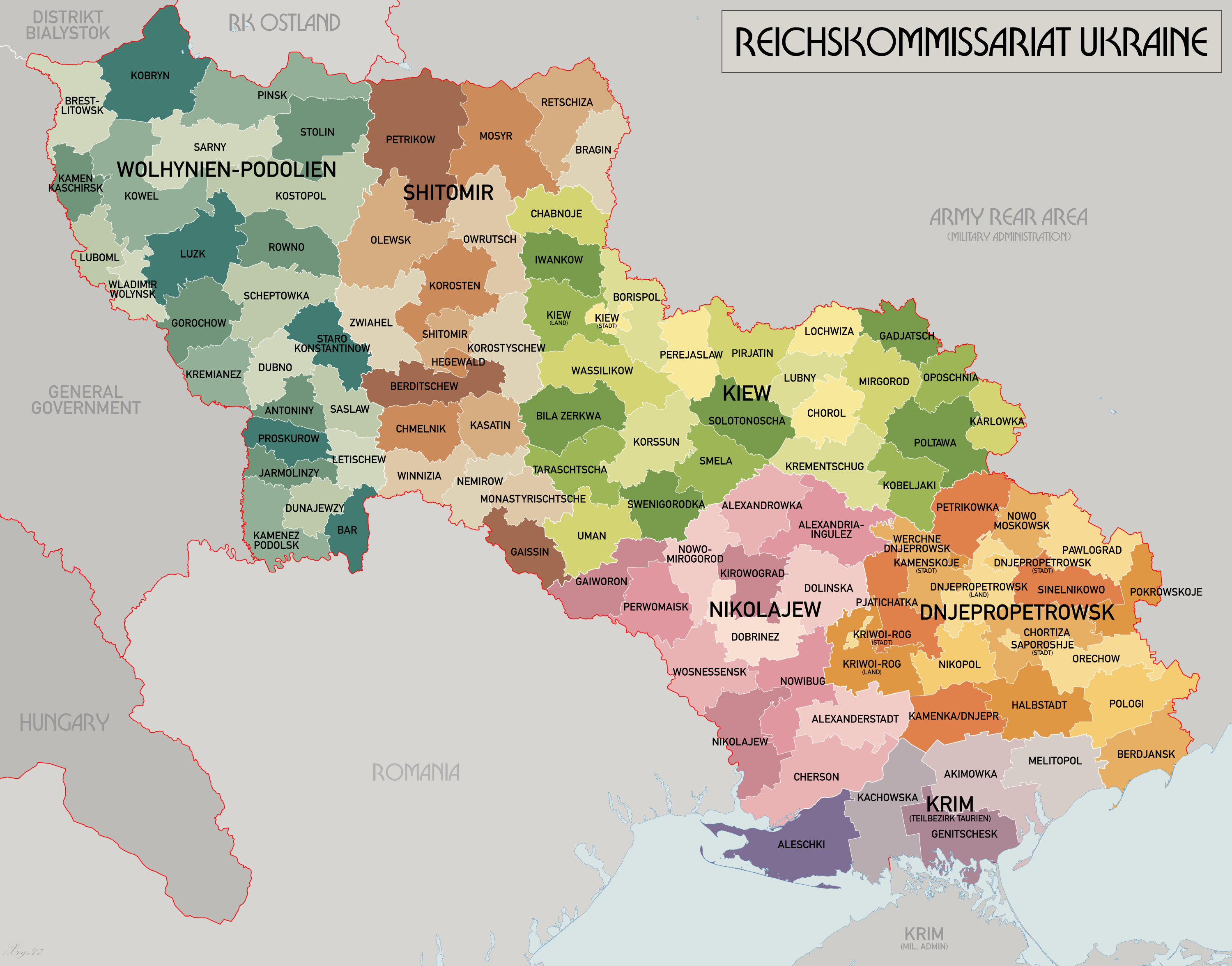
English: An administrative map of the Reichskommissariat Ukraine. Shows the boundaries of the Generalbezirke and Kreisgebiete as of September 1943. |
| Dátum | |
| Zdroj | Vlastné dielo |
| Autor | XrysD |
| Ďalšie verzie | Díla odvozená od tohoto souboru: HegewaldColonyMap.png |
Licencovanie
Ja, držiteľ autorských práv k tomuto dielu ho týmto zverejňujem za podmienok nasledovnej licencie:

|
Bolo udelené povolenie kopírovať, širiť a/alebo meniť tento dokument za podmienok GNU Free Documentation License, verzie 1.2 alebo ktorejkoľvek neskoršej verzie publikovanej Free Software Foundation; bez Nemenných častí, bez Textov na prednej obálke a bez Textov na zadnej obálke. Kópia tejto licencie je zahrnutá v časti nazvanej GNU Free Documentation License. |
| Tento súbor podlieha licencii Creative Commons Attribution-Share Alike 3.0 Unported | ||
| ||
| Táto šablóna licencie bola pridaná k tomuto súboru počas aktualizácie licencovania GFDL. |
História súboru
Po kliknutí na dátum/čas uvidíte ako súbor vyzeral vtedy.
| Dátum/Čas | Náhľad | Rozmery | Používateľ | Komentár | |
|---|---|---|---|---|---|
| aktuálna | 09:25, 21. máj 2017 | | 3 000 × 2 352 (1,36 MB) | XrysD | Reduced size and fixed edge issue. |
| 09:21, 21. máj 2017 |  | 4 000 × 3 197 (1,95 MB) | XrysD | Completely new version. Source map data: [Verwaltungskarten Gebietes Ukraine 1:500k, US Library of Congress], [Karte des Deutschen Reiches (Grossblatter) 1:100k, Mapa Administracyjna Rzeczypospolitej Polska 1:300k, Karte von Mitteleuropa 1:300k, MapyWig] | |
| 16:39, 8. december 2015 |  | 1 803 × 1 060 (714 KB) | Artemco | • occupied territory under military administration, not directly Soviet Union • capital letters as Romania had • C → G | |
| 20:59, 16. máj 2012 |  | 1 803 × 1 060 (708 KB) | XrysD | Added legend. Changed surrounding state names to common English versions. Changed colour set to Bartholomew version. | |
| 13:01, 22. júl 2008 |  | 1 803 × 1 060 (205 KB) | XrysD | {{Information |Description={{en|1=An administrative map of the Reichskommissariat Ukraine. Shows the boundaries of the Generalbezirke and Kreisgebiete as of September 1943.}} |Source=Own work by uploader |Author=XrysD |Date=2008 |Permission |
Použitie súboru
Žiadne stránky neobsahujú odkazy na tento súbor.
Globálne využitie súborov
Nasledovné ďalšie wiki používajú tento súbor:
- Použitie na ar.wikipedia.org
- Použitie na az.wikipedia.org
- Použitie na be-tarask.wikipedia.org
- Použitie na be.wikipedia.org
- Použitie na bs.wikipedia.org
- Použitie na ca.wikipedia.org
- Použitie na cs.wikipedia.org
- Použitie na da.wikipedia.org
- Použitie na en.wikipedia.org
- Použitie na es.wikipedia.org
- Použitie na fa.wikipedia.org
- Použitie na fr.wikipedia.org
- Použitie na he.wikipedia.org
- Použitie na hr.wikipedia.org
- Použitie na it.wikipedia.org
- Použitie na ja.wikipedia.org
- Použitie na lt.wikipedia.org
- Použitie na ms.wikipedia.org
- Použitie na mt.wikipedia.org
- Použitie na nl.wikipedia.org
- Použitie na pl.wikipedia.org
- Použitie na pt.wikipedia.org
- Použitie na ro.wikipedia.org
- Použitie na ru.wikipedia.org
- Použitie na sh.wikipedia.org
- Použitie na sr.wikipedia.org
- Použitie na sv.wikipedia.org
- Použitie na th.wikipedia.org
- Použitie na uk.wikipedia.org
Zobraziť ďalšie globálne použitie tohto súboru.