
Súbor:Roman provinces trajan.svg

Veľkosť tohoto PNG náhľadu tohoto SVG súboru: 800 × 457 pixelov. Iné rozlíšenia: 320 × 183 pixelov | 640 × 366 pixelov | 1 024 × 585 pixelov | 1 280 × 732 pixelov | 2 560 × 1 463 pixelov | 1 732 × 990 pixelov .
Pôvodný súbor (SVG súbor, 1 732 × 990 pixelov, veľkosť súboru: 757 KB)
Zhrnutie
| Popis |
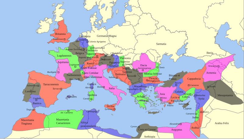
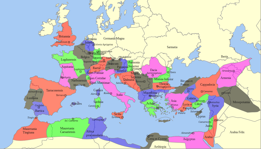
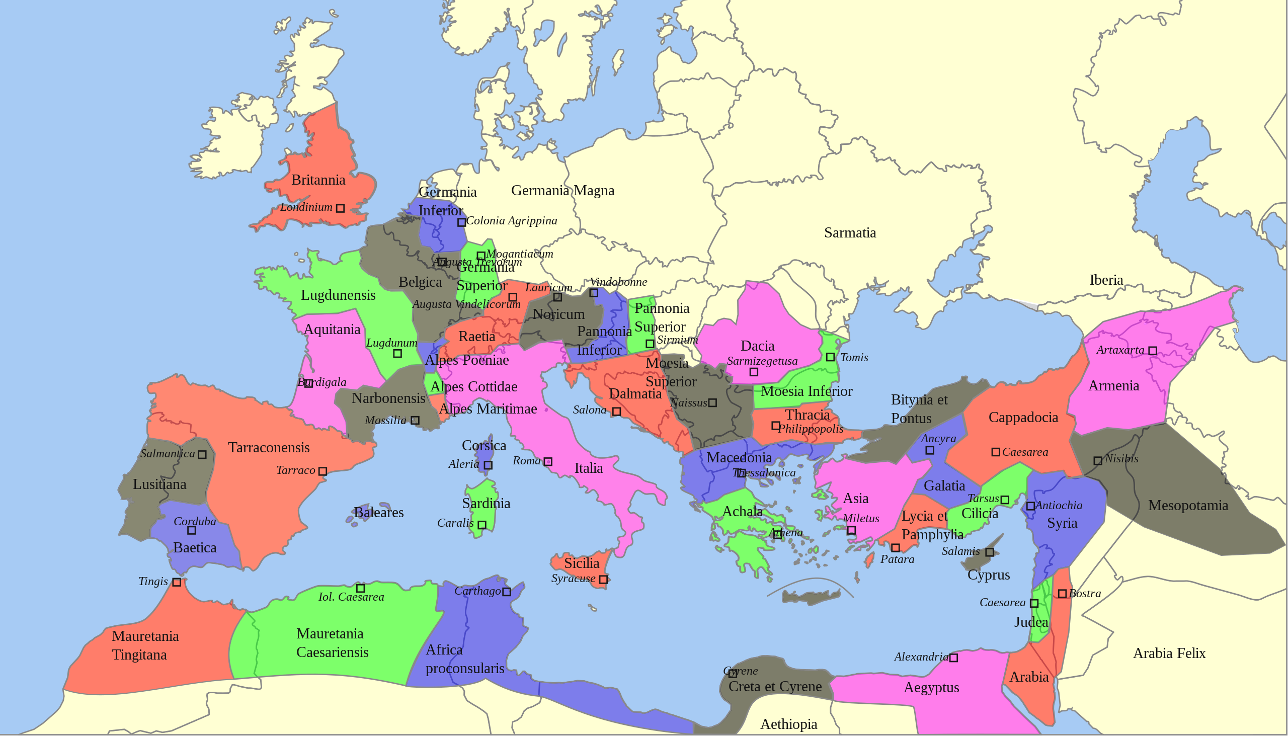
Deutsch: Territoriale Ausdehnung und provinziale Aufteilung des Römischen Reichs unter Trajan (117 n. Chr.) auf einer politischen Karte von 2013
English: Territorial extension and provincial division of the Roman Empire under Trajan (117 AD) on a political map of 2013 |
| Dátum | |
| Zdroj |
Tento soubor byl odvozen z: |
| Autor |
|
| SVG vývoj | Táto grafika bola vytvorená pomocou CorelDRAW. |
Licencovanie
Sebastian Wallroth, držiteľ autorských práv k tomuto dielu ho týmto zverejňuje za podmienok nasledovnej licencie:
| Ja, držiteľ autorských práv k tomuto dielu, uvoľňujem toto dielo ako voľné dielo (public domain). Toto platí celosvetovo. V niektorých krajinách to zákon neumožňuje; v tom prípade: Udeľujem komukoľvek právo používať toto dielo na ľubovoľné účely, bez akýchkoľvek podmienok ak také podmienky nevyžaduje zákon. |
Pôvodný záznam nahrávaní
This image is a derivative work of the following images:
- Roemischeprovinzentrajan.png licensed with PD-Demis
- 2007-06-29T05:49:35Z ThomasPusch 1218x730 (314106 Bytes) Name of "Mauretania Caesariensis'' (one "s" was missing) corrected - Name von "Mauretania Caesariensis" berichtigt - nomo de "Mauretania Caesariensis'' korektita
- 2005-11-27T11:10:02Z FJ-de 1218x730 (339534 Bytes) Karte ist erstellt von mir - Vorlage Demis http://www.demis.nl/wms/mapclip.htm
- Blank Map of Europe -w boundaries.svg licensed with Cc-by-sa-2.5,2.0,1.0, Cc-by-sa-3.0-migrated, GFDL
- 2008-06-19T01:33:53Z Roke 2045x1720 (724499 Bytes) more accurate version derived from [[:Image:Location European nation states.svg]] using same colours
- 2006-09-25T23:00:04Z Madman2001 0x0 (224972 Bytes) A blank map of Europe using Wikipedia standard colors in SVG format, based on [[:Image:BlankMap-Europe-v5.png]]. Note that the borders represent a second object "grouped" with the outline of Europe.
Uploaded with derivativeFX
História súboru
Po kliknutí na dátum/čas uvidíte ako súbor vyzeral vtedy.
| Dátum/Čas | Náhľad | Rozmery | Používateľ | Komentár | |
|---|---|---|---|---|---|
| aktuálna | 06:59, 22. február 2022 | | 1 732 × 990 (757 KB) | Chaddy | Reverted to version as of 08:05, 17 May 2013 (UTC) this map is heavily broken since September |
| 17:00, 24. september 2021 |  | 1 732 × 990 (576 KB) | Sebastian Wallroth | invalid element removed // Editing SVG source code using c:User:Rillke/SVGedit.js | |
| 16:55, 24. september 2021 |  | 1 732 × 990 (576 KB) | Sebastian Wallroth | justified // Editing SVG source code using c:User:Rillke/SVGedit.js | |
| 16:52, 24. september 2021 |  | 1 732 × 990 (577 KB) | Sebastian Wallroth | edited // Editing SVG source code using c:User:Rillke/SVGedit.js | |
| 16:48, 24. september 2021 |  | 1 732 × 990 (579 KB) | Sebastian Wallroth | code reviewed // Editing SVG source code using c:User:Rillke/SVGedit.js | |
| 08:05, 17. máj 2013 |  | 1 732 × 990 (757 KB) | Sebastian Wallroth | pure SVG | |
| 07:51, 17. máj 2013 |  | 1 732 × 990 (756 KB) | Sebastian Wallroth | cut out | |
| 07:49, 17. máj 2013 |  | 2 043 × 982 (679 KB) | Sebastian Wallroth | == {{int:filedesc}} == {{Information |Description={{de|Territoriale Ausdehnung und provinziale Aufteilung des Römischen Reichs unter Trajan (117 n. Chr.) auf einer politischen Karte von 2013}} {{en|Territorial extension and provincial division of the ... |
Použitie súboru
Na tento súbor odkazuje nasledujúca stránka:
Globálne využitie súborov
Nasledovné ďalšie wiki používajú tento súbor:
- Použitie na en.wikipedia.org
- Použitie na es.wikibooks.org