
Súbor:Cat Island map.png

Veľkosť tohto náhľadu: 787 × 599 pixelov. Iné rozlíšenia: 315 × 240 pixelov | 630 × 480 pixelov | 1 009 × 768 pixelov | 1 258 × 958 pixelov .
Pôvodný súbor (1 258 × 958 pixelov, veľkosť súboru: 181 KB, MIME typ: image/png)
Zhrnutie
| Popis |
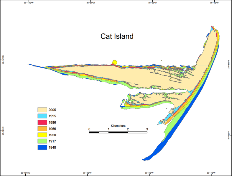
English: Historical geomorphology of Cat Island, Mississippi, showing the shoreline at various dates |
| Dátum | |
| Zdroj | Morton, Robert A.. 8, 2020 Historical Changes in the Mississippi–Alabama Barrier Islands and the Roles of Extreme Storms, Sea Level, and Human Activities. USGS Publications Warehouse. United States Geological Survey.[dead link] |
| Autor |
Robert A. Morton U.S. Geological Survey |
Licencovanie
Toto dílo je ve Spojených státech volným dílem, protože jde o dílo úřadů americké federální vlády podle ustanovení Hlavy 17, Kapitoly 1, Sekce 105 amerického právního řádu. Viz Autorské právo.
Upozornění: uvedené se vztahuje pouze na díla úřadů federální vlády, nikoliv na úřady jednotlivých států, okresů, či nižších územně správních jednotek.
|
 | |
| Tento súbor bol identifikovaný, že nemá žiadne známe obmedzenia vyplývajúce z autorského zákona vrátane všetkých súvisiacich a susedných práv. | ||
História súboru
Po kliknutí na dátum/čas uvidíte ako súbor vyzeral vtedy.
| Dátum/Čas | Náhľad | Rozmery | Používateľ | Komentár | |
|---|---|---|---|---|---|
| aktuálna | 01:02, 11. október 2020 | | 1 258 × 958 (181 KB) | Bryanrutherford0 | Uploaded a work by Robert A. Morton U.S. Geological Survey from {{Cite web|title=Historical Changes in the Mississippi–Alabama Barrier Islands and the Roles of Extreme Storms, Sea Level, and Human Activities|website=USGS Publications Warehouse|publisher=United States Geological Survey|first=Robert A.|last=Morton|url=https://pubs.usgs.gov/of/2007/1161/OFR-2007-1161-screen.pdf|accessdate=October 8, 2020}} with UploadWizard |
Použitie súboru
Žiadne stránky neobsahujú odkazy na tento súbor.
Globálne využitie súborov
Nasledovné ďalšie wiki používajú tento súbor:
- Použitie na en.wikipedia.org