
Súbor:East of England districts 2011 map.svg

Veľkosť tohoto PNG náhľadu tohoto SVG súboru: 573 × 600 pixelov. Iné rozlíšenia: 229 × 240 pixelov | 459 × 480 pixelov | 734 × 768 pixelov | 979 × 1 024 pixelov | 1 957 × 2 048 pixelov | 1 210 × 1 266 pixelov .
Pôvodný súbor (SVG súbor, 1 210 × 1 266 pixelov, veľkosť súboru: 2,14 MB)
Zhrnutie
| Popis |
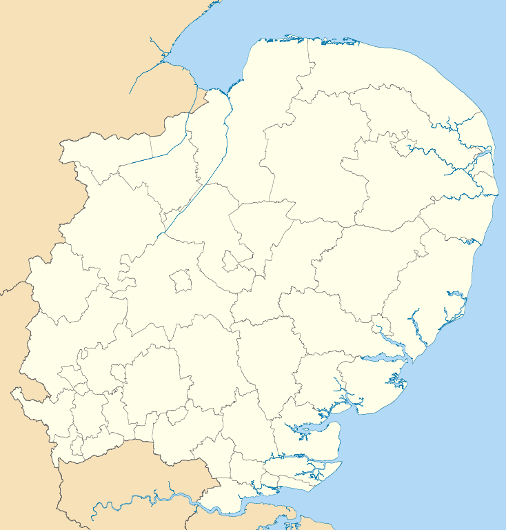
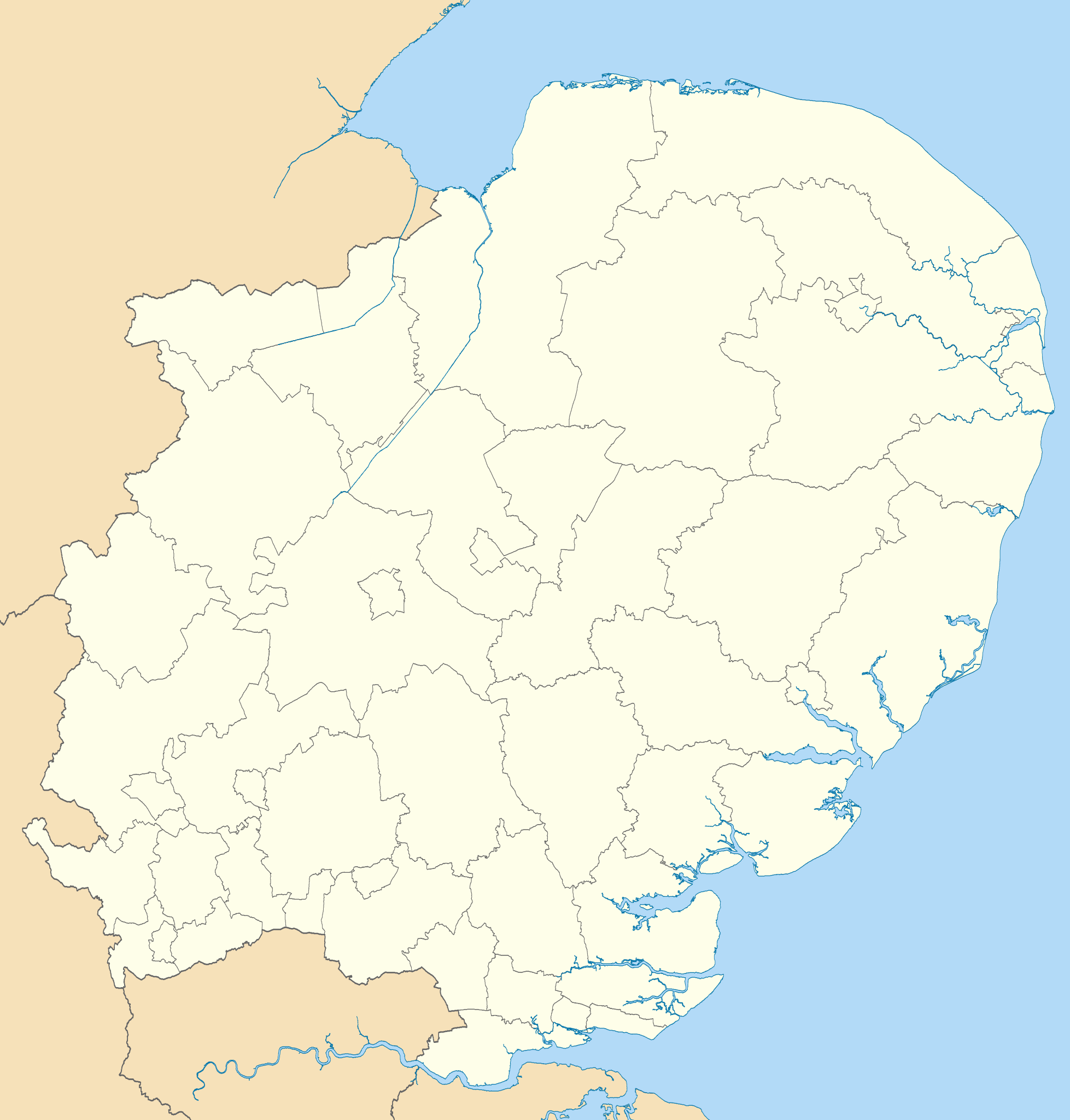
Map of the East of England region showing the administrative districts. Equirectangular map projection on WGS 84 datum, with N/S stretched 160% Geographic limits:
|
| Dátum | |
| Zdroj |
|
| Autor | Nilfanion, created using Ordnance Survey data |
| Ďalšie verzie |
Derivative works of this file: |
Licencovanie
Ja, držiteľ autorských práv k tomuto dielu ho týmto zverejňujem za podmienok nasledovných licencií:
Tento súbor podlieha licencii Creative Commons Attribution-Share Alike 3.0 Unported
- Môžete slobodne:
- zdieľať – kopírovať, šíriť a prenášať dielo
- meniť ho – upravovať dielo
- Za nasledovných podmienok:
- uvedenie autorov – Musíte spomenúť autorov (jednotlivo alebo kolektívne), poskytnúť odkaz na licenciu a uviesť, či ste niečo zmenili. Môžete to urobiť ľubovoľným primeraným spôsobom, ale nie spôsobom naznačujúcim, že poskytovateľ licencie podporuje vás alebo vaše použitie diela.
- meniť za rovnakých podmienok – Ak toto dielo zmeníte, prevediete do inej formy alebo použijete ako základ iného diela, musíte výsledok šíriť pod rovnakou alebo kompatibilnou licenciou ako originál.

|
Bolo udelené povolenie kopírovať, širiť a/alebo meniť tento dokument za podmienok GNU Free Documentation License, verzie 1.2 alebo ktorejkoľvek neskoršej verzie publikovanej Free Software Foundation; bez Nemenných častí, bez Textov na prednej obálke a bez Textov na zadnej obálke. Kópia tejto licencie je zahrnutá v časti nazvanej GNU Free Documentation License. |
Môžete si zvoliť ľubovolnú z týchto licencií.
História súboru
Po kliknutí na dátum/čas uvidíte ako súbor vyzeral vtedy.
| Dátum/Čas | Náhľad | Rozmery | Používateľ | Komentár | |
|---|---|---|---|---|---|
| aktuálna | 18:51, 1. máj 2011 | | 1 210 × 1 266 (2,14 MB) | Nilfanion | {{Information |Description=Map of the East of England region showing the administrative districts. Equirectangular map projection on WGS 84 datum, with N/S stretched 160% Geographic limits: *West: 0.8W *East: 1.8E *North: 53.1N *So |
Použitie súboru
Žiadne stránky neobsahujú odkazy na tento súbor.
Globálne využitie súborov
Nasledovné ďalšie wiki používajú tento súbor:
- Použitie na ar.wikipedia.org
- Použitie na en.wikipedia.org
- Cambridge
- East of England
- Luton
- Ipswich
- Thurrock
- Norwich
- Huntingdonshire
- Southend-on-Sea
- Welwyn Hatfield
- Stevenage
- Harlow
- Watford
- King's Lynn and West Norfolk
- St Albans City and District
- City of Peterborough
- South Cambridgeshire
- East Cambridgeshire
- Fenland District
- Castle Point
- Uttlesford
- Tendring District
- Hertsmere
- Borough of Broxbourne
- East Hertfordshire
- North Hertfordshire
- Dacorum
- South Norfolk
- Broadland
- Breckland District
- North Norfolk
- Mid Suffolk
- Babergh District
- Template:East of England
- Borough of Bedford
- Braintree District
- City of Colchester
- Epping Forest District
- Borough of Basildon
- Maldon District
- Borough of Great Yarmouth
- Rochford District
- City of Chelmsford
- Borough of Brentwood
- Eastern Counties Football League
- Three Rivers District
- User:Mwphoto/Watford
- User:Phildav76/Regional templates
- Old Harlow
Zobraziť ďalšie globálne použitie tohto súboru.