
Súbor:Kansas City Southern Railway system map.svg

Veľkosť tohoto PNG náhľadu tohoto SVG súboru: 800 × 457 pixelov. Iné rozlíšenia: 320 × 183 pixelov | 640 × 366 pixelov | 1 024 × 585 pixelov | 1 280 × 731 pixelov | 2 560 × 1 463 pixelov | 1 400 × 800 pixelov .
Pôvodný súbor (SVG súbor, 1 400 × 800 pixelov, veľkosť súboru: 543 KB)
Zhrnutie
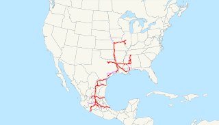
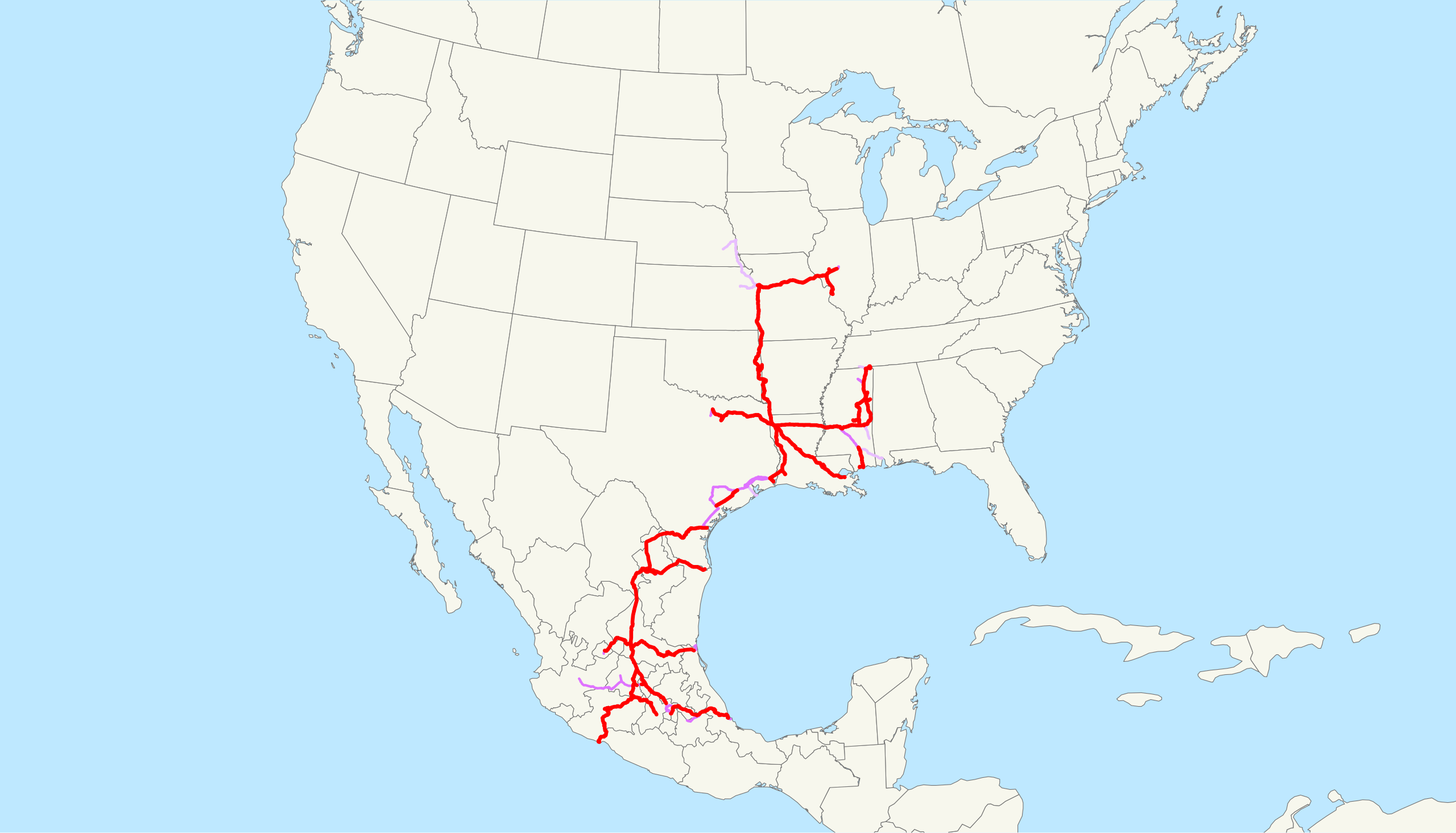
| Popis | This is a map of the Kansas City Southern Railway as of 2009, with trackage rights in purple (haulage rights are lighter). Email me if you would like a copy of the GIS data I created (modified from Bureau of Transportation Statistics North American Transportation Atlas Data) or if you see any errors. |
| Dátum | 20. februára 2009 (datum prvotního načtení souboru) |
| Zdroj | No machine-readable source provided. Own work assumed (based on copyright claims). |
| Autor | No machine-readable author provided. NE2 assumed (based on copyright claims). |
Licencovanie
| Ja, držiteľ autorských práv k tomuto dielu, uvoľňujem toto dielo ako voľné dielo (public domain). Toto platí celosvetovo. V niektorých krajinách to zákon neumožňuje; v tom prípade: Udeľujem komukoľvek právo používať toto dielo na ľubovoľné účely, bez akýchkoľvek podmienok ak také podmienky nevyžaduje zákon. |
História súboru
Po kliknutí na dátum/čas uvidíte ako súbor vyzeral vtedy.
| Dátum/Čas | Náhľad | Rozmery | Používateľ | Komentár | |
|---|---|---|---|---|---|
| aktuálna | 13:09, 23. február 2009 | | 1 400 × 800 (543 KB) | NE2 | Changed the display of lines owned by the government for the purposes of passenger rail, so that if KCS is the primary freight operator it is not shown as trackage rights. |
| 04:30, 20. február 2009 |  | 1 400 × 800 (542 KB) | NE2 | == Summary == This is a map of the Kansas City Southern Railway as of 2009, with trackage rights in purple (haulage rights are lighter). Email me if you would like a copy of the GIS dat |
Použitie súboru
Žiadne stránky neobsahujú odkazy na tento súbor.
Globálne využitie súborov
Nasledovné ďalšie wiki používajú tento súbor:
- Použitie na de.wikipedia.org
- Použitie na en.wikipedia.org
- Použitie na es.wikipedia.org
- Použitie na fr.wikipedia.org
- Použitie na hu.wikipedia.org
- Použitie na id.wikipedia.org
- Použitie na it.wikipedia.org
- Použitie na ja.wikipedia.org
- Použitie na ko.wikipedia.org
- Použitie na nl.wikipedia.org
- Použitie na pt.wikipedia.org
- Použitie na www.wikidata.org
- Použitie na zh.wikipedia.org