
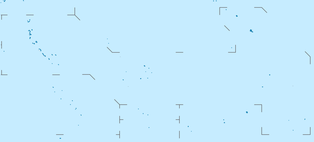
Súbor:Kiribati location map.svg

Pôvodný súbor (SVG súbor, 1 488 × 673 pixelov, veľkosť súboru: 68 KB)
Zhrnutie
| Popis |
Deutsch: Positionskarte von Kiribati
Quadratische Plattkarte. Geographische Begrenzung der Karte:
English: Location map of Kiribati
Equirectangular projection. Geographic limits of the map:
|
|
| Dátum | ||
| Zdroj |
Vlastné dielo, using
|
|
| Autor | NordNordWest | |
| Povolenie (Využívanie tohto súboru) |
Tento súbor je licencovaný za podmienok Creative Commons Attribution-Share Alike 3.0 Germany.
 Tento súbor je licencovaný za podmienok Creative Commons Attribution-Share Alike 3.0 Germany.
|
|
| Ďalšie verzie |
|


|
Tato mapa byla vytvořena nebo vylepšena v německé Kartenwerkstatt (Mapová laboratoř). Můžete také navrhnout mapy k vylepšení.
|
História súboru
Po kliknutí na dátum/čas uvidíte ako súbor vyzeral vtedy.
| Dátum/Čas | Náhľad | Rozmery | Používateľ | Komentár | |
|---|---|---|---|---|---|
| aktuálna | 15:52, 23. február 2021 | | 1 488 × 673 (68 KB) | NordNordWest | Reverted to version as of 09:54, 1 April 2010 (UTC), sorry, but this is not location map style |
| 13:08, 23. február 2021 |  | 1 488 × 673 (137 KB) | Amitchell125 | borders made visible with minor corrections | |
| 09:54, 1. apríl 2010 |  | 1 488 × 673 (68 KB) | NordNordWest | c | |
| 20:04, 5. marec 2010 |  | 1 488 × 673 (84 KB) | NordNordWest | == {{int:filedesc}} == {{Information |Description= {{de|Positionskarte von Kiribati}} Quadratische Plattkarte. Geographische Begrenzung der Karte: * N: 6° N * S: 13° S * W: 169° O * O: 149° W {{en|Location map of [[:en:Kiribati|Kiriba |
Použitie súboru
Žiadne stránky neobsahujú odkazy na tento súbor.
Globálne využitie súborov
Nasledovné ďalšie wiki používajú tento súbor:
- Použitie na af.wikipedia.org
- Použitie na als.wikipedia.org
- Použitie na an.wikipedia.org
- Použitie na ar.wikipedia.org
- Použitie na ast.wikipedia.org
- Použitie na az.wikipedia.org
- Použitie na ba.wikipedia.org
- Použitie na be-tarask.wikipedia.org
- Použitie na be.wikipedia.org
- Použitie na bg.wikipedia.org
- Použitie na bh.wikipedia.org
- Použitie na bn.wikipedia.org
- Použitie na bs.wikipedia.org
- Použitie na ceb.wikipedia.org
Zobraziť ďalšie globálne použitie tohto súboru.