
Súbor:Louisiane 1800.png
Nie je dostupné vyššie rozlíšenie.
Louisiane_1800.png (383 × 329 pixelov, veľkosť súboru: 9 KB, MIME typ: image/png)
Zhrnutie

|
Tento obrázek (skupina locator map) by měl být vytvořen pomocí vektorové grafiky jako SVG soubor. To má několik výhod; podrobnosti najdete na stránce Commons:Media for cleanup. Je-li SVG verze tohoto obrázku již k dispozici, prosím nahrajte ji. Po nahrání nahraďte tuto šablonu šablonou {{Vector version available|jméno nového obrázku.svg}}.
|
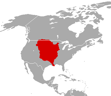
| Popis |
English: The Louisiana Territory as it was from 1763 to 1803.
Français : Le territoire de Louisiane tel qu'il l'était de 1763 à 1803.
Español: La Louisiana Territorio como lo fue desde 1763 a 1803. |
| Dátum | |
| Zdroj | File:LouisianaPurchase.png |
| Autor | Neznámý |
Licencovanie

|
Bolo udelené povolenie kopírovať, širiť a/alebo meniť tento dokument za podmienok GNU Free Documentation License, verzie 1.2 alebo ktorejkoľvek neskoršej verzie publikovanej Free Software Foundation; bez Nemenných častí, bez Textov na prednej obálke a bez Textov na zadnej obálke. Kópia tejto licencie je zahrnutá v časti nazvanej GNU Free Documentation License. |
| Tento súbor podlieha licencii Creative Commons Attribution-Share Alike 3.0 Unported | ||
| ||
| Táto šablóna licencie bola pridaná k tomuto súboru počas aktualizácie licencovania GFDL. |
Pôvodný záznam nahrávaní
(All user names refer to fr.wikipedia)
- 2003-09-01 20:34 F5ZV 412×306×8 (7986 bytes) carte de la Louisiane en 1800 au moment de la vente par Napoléon aux Etats-Unis.
História súboru
Po kliknutí na dátum/čas uvidíte ako súbor vyzeral vtedy.
| Dátum/Čas | Náhľad | Rozmery | Používateľ | Komentár | |
|---|---|---|---|---|---|
| aktuálna | 00:57, 16. december 2010 | | 383 × 329 (9 KB) | Maps & Lucy | fixed the border along New Spain and changed colour to Spanish Red due to it being a territory of New Spain |
| 15:14, 18. august 2010 |  | 383 × 329 (9 KB) | Maps & Lucy | {{Information |Description=''English:'' The Louisiana Territory as it was from 1763 to 1803. <br> ''Français:'' La Louisiane territoire comme il a été de 1763 à 1803. <br> ''Español:'' La Louisiana Territorio como lo fue desde 1763 a 1803. |Source=[[ | |
| 11:23, 29. január 2007 |  | 412 × 306 (8 KB) | Bilou~commonswiki | {{Information |Description=carte de la Louisiane en 1800 au moment de la vente par Napoléon aux États-Unis. |Source=Dessinée par F5ZV |Date=2003-09-01 (original upload date) |Author=F5ZV at [http://fr.wikipedi |
Použitie súboru
Žiadne stránky neobsahujú odkazy na tento súbor.
Globálne využitie súborov
Nasledovné ďalšie wiki používajú tento súbor:
- Použitie na ar.wikipedia.org
- Použitie na de.wikipedia.org
- Použitie na en.wikipedia.org
- Použitie na eo.wikipedia.org
- Použitie na et.wikipedia.org
- Použitie na fr.wikipedia.org
- Použitie na it.wikipedia.org
- Použitie na ja.wikipedia.org
- Použitie na ko.wikipedia.org
- Použitie na mg.wikipedia.org
- Použitie na pcd.wikipedia.org
- Použitie na pt.wikipedia.org