
Súbor:Map of northern Iran under late Sasanian rule.png

Veľkosť tohto náhľadu: 800 × 397 pixelov. Iné rozlíšenia: 320 × 159 pixelov | 640 × 317 pixelov | 1 024 × 508 pixelov | 1 789 × 887 pixelov .
Pôvodný súbor (1 789 × 887 pixelov, veľkosť súboru: 1,53 MB, MIME typ: image/png)
Zhrnutie
| Popis |
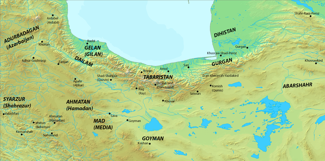
English: Map of northern Iran under late Sasanian rule.
|
| Dátum | |
| Zdroj | Vlastné dielo |
| Autor | HistoryofIran |
Licencovanie
Ja, držiteľ autorských práv k tomuto dielu ho týmto zverejňujem za podmienok nasledovnej licencie:
Tento súbor podlieha licencii Creative Commons Attribution-Share Alike 3.0 Unported
- Môžete slobodne:
- zdieľať – kopírovať, šíriť a prenášať dielo
- meniť ho – upravovať dielo
- Za nasledovných podmienok:
- uvedenie autorov – Musíte spomenúť autorov (jednotlivo alebo kolektívne), poskytnúť odkaz na licenciu a uviesť, či ste niečo zmenili. Môžete to urobiť ľubovoľným primeraným spôsobom, ale nie spôsobom naznačujúcim, že poskytovateľ licencie podporuje vás alebo vaše použitie diela.
- meniť za rovnakých podmienok – Ak toto dielo zmeníte, prevediete do inej formy alebo použijete ako základ iného diela, musíte výsledok šíriť pod rovnakou alebo kompatibilnou licenciou ako originál.
História súboru
Po kliknutí na dátum/čas uvidíte ako súbor vyzeral vtedy.
| Dátum/Čas | Náhľad | Rozmery | Používateľ | Komentár | |
|---|---|---|---|---|---|
| aktuálna | 00:55, 19. jún 2014 | | 1 789 × 887 (1,53 MB) | HistoryofIran | =={{int:filedesc}}== {{Information |description={{en|1=Map of northern Iran under late Sasanian rule. *Map taken from [http://www2.demis.nl/ DEMIS Mapserver], which is public domain, the rest is self-made.}} |date=2014... |
Použitie súboru
Žiadne stránky neobsahujú odkazy na tento súbor.
Globálne využitie súborov
Nasledovné ďalšie wiki používajú tento súbor:
- Použitie na ar.wikipedia.org
- Použitie na azb.wikipedia.org
- Použitie na en.wikipedia.org
- Použitie na es.wikipedia.org
- Použitie na fa.wikipedia.org
- Použitie na it.wikipedia.org
- Použitie na ja.wikipedia.org
- Použitie na pt.wikipedia.org
- Použitie na ru.wikipedia.org
- Použitie na sr.wikipedia.org
- Použitie na ur.wikipedia.org
- Použitie na vi.wikipedia.org