
Súbor:NorthAmerica1763-A.png
Nie je dostupné vyššie rozlíšenie.
NorthAmerica1763-A.png (787 × 600 pixelov, veľkosť súboru: 43 KB, MIME typ: image/png)
Zhrnutie
| Popis |
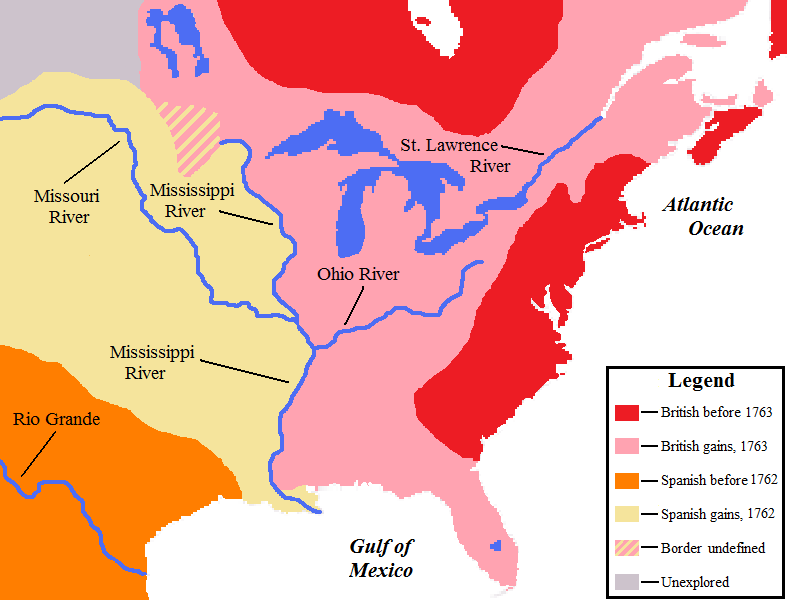
English: Map showing the North American territorial gains of Spain in 1762 and Britain in 1763. |
| Dátum | |
| Zdroj | Own work by uploader, base map used is found here, uploaded by User:Roke |
| Autor | AlexiusHoratius |
Licencovanie
Ja, držiteľ autorských práv k tomuto dielu ho týmto zverejňujem za podmienok nasledovných licencií:
Tento súbor podlieha licencii Creative Commons Attribution-Share Alike 3.0 Unported
- Môžete slobodne:
- zdieľať – kopírovať, šíriť a prenášať dielo
- meniť ho – upravovať dielo
- Za nasledovných podmienok:
- uvedenie autorov – Musíte spomenúť autorov (jednotlivo alebo kolektívne), poskytnúť odkaz na licenciu a uviesť, či ste niečo zmenili. Môžete to urobiť ľubovoľným primeraným spôsobom, ale nie spôsobom naznačujúcim, že poskytovateľ licencie podporuje vás alebo vaše použitie diela.
- meniť za rovnakých podmienok – Ak toto dielo zmeníte, prevediete do inej formy alebo použijete ako základ iného diela, musíte výsledok šíriť pod rovnakou alebo kompatibilnou licenciou ako originál.

|
Bolo udelené povolenie kopírovať, širiť a/alebo meniť tento dokument za podmienok GNU Free Documentation License, verzie 1.2 alebo ktorejkoľvek neskoršej verzie publikovanej Free Software Foundation; bez Nemenných častí, bez Textov na prednej obálke a bez Textov na zadnej obálke. Kópia tejto licencie je zahrnutá v časti nazvanej GNU Free Documentation License. |
Môžete si zvoliť ľubovolnú z týchto licencií.
Notes
- The pink coloring specifically designates territory that Britain held without question after 1763; included are both areas that had been under full Spanish or French control and then lost, as well as areas disputedly claimed by Britain before 1763.
- Florida was held by Spain prior to 1763; on the map it is shown only as a British gain, and appears no different from territory lost by France.
- The undefined boundary in the upper watershed of the Red River of the North was due to confusion at the time as to the location of the headwaters of the Mississippi River. (The source of the Mississippi was believed to have been further north than its actual location.)
História súboru
Po kliknutí na dátum/čas uvidíte ako súbor vyzeral vtedy.
| Dátum/Čas | Náhľad | Rozmery | Používateľ | Komentár | |
|---|---|---|---|---|---|
| aktuálna | 00:16, 26. september 2008 | | 787 × 600 (43 KB) | AlexiusHoratius~commonswiki | {{Information |Description={{en|1=Map showing the territorial gains by Britain and Spain in North America in 1762 and 1763.}} |Source=Own work by uploader |Author=AlexiusHoratius |Date=25 September 2008 |Permission= |other_version |
Použitie súboru
Žiadne stránky neobsahujú odkazy na tento súbor.
Globálne využitie súborov
Nasledovné ďalšie wiki používajú tento súbor:
- Použitie na en.wikipedia.org
- Použitie na mt.wikipedia.org
- Použitie na sv.wikipedia.org