
Súbor:OxfordshireSouth.png
Nie je dostupné vyššie rozlíšenie.
OxfordshireSouth.png (200 × 267 pixelov, veľkosť súboru: 16 KB, MIME typ: image/png)
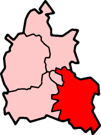
South Oxfordshire in Oxfordshire
Created by en:User:Morwen

|
Bolo udelené povolenie kopírovať, širiť a/alebo meniť tento dokument za podmienok GNU Free Documentation License, verzie 1.2 alebo ktorejkoľvek neskoršej verzie publikovanej Free Software Foundation; bez Nemenných častí, bez Textov na prednej obálke a bez Textov na zadnej obálke. Kópia tejto licencie je zahrnutá v časti nazvanej GNU Free Documentation License. |
| Tento súbor podlieha licencii Creative Commons Attribution-Share Alike 3.0 Unported | ||
| ||
| Táto šablóna licencie bola pridaná k tomuto súboru počas aktualizácie licencovania GFDL. |
História súboru
Po kliknutí na dátum/čas uvidíte ako súbor vyzeral vtedy.
| Dátum/Čas | Náhľad | Rozmery | Používateľ | Komentár | |
|---|---|---|---|---|---|
| aktuálna | 23:25, 29. júl 2005 | | 200 × 267 (16 KB) | Cnyborg | South Oxfordshire i Oxfordshire, England. From en:Image:OxfordshireSouth.png by en:User:Morwen {{GFDL-en}} |
Použitie súboru
Žiadne stránky neobsahujú odkazy na tento súbor.
Globálne využitie súborov
Nasledovné ďalšie wiki používajú tento súbor:
- Použitie na de.wikipedia.org
- Použitie na en.wikipedia.org
- Henley-on-Thames
- Wallingford, Oxfordshire
- Garsington
- Didcot
- Thame
- Towersey
- South Oxfordshire
- Elsfield
- Dorchester on Thames
- Brightwell-cum-Sotwell
- Goring-on-Thames
- Shotover
- Whitchurch-on-Thames
- Culham
- Roke
- Wantage (UK Parliament constituency)
- Henley (UK Parliament constituency)
- Shiplake
- Nettlebed
- Crowmarsh Gifford
- Benson, Oxfordshire
- Sonning Eye
- Cholsey
- Waterstock
- Ewelme
- Berrick Salome
- Adwell
- Watlington, Oxfordshire
- Wheatley, Oxfordshire
- South Stoke, Oxfordshire
- Great Milton
- Clifton Hampden
- Chinnor
- Pishill
- Aston Tirrold
- Aston Upthorpe
- Aston Rowant
- Beckley and Stowood
- Berinsfield
- Binfield Heath
- Bix and Assendon
- Henley Rural District
- Rotherfield Greys
- Waterperry
- Playhatch
- Dunsden Green
- Sandford-on-Thames
- Bullingdon Rural District
- Culham Rural District
Zobraziť ďalšie globálne použitie tohto súboru.