
Súbor:OxfordshireWest.png
Nie je dostupné vyššie rozlíšenie.
OxfordshireWest.png (200 × 267 pixelov, veľkosť súboru: 11 KB, MIME typ: image/png)
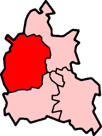
West Oxfordshire in Oxfordshire
Created by en:User:Morwen

|
Bolo udelené povolenie kopírovať, širiť a/alebo meniť tento dokument za podmienok GNU Free Documentation License, verzie 1.2 alebo ktorejkoľvek neskoršej verzie publikovanej Free Software Foundation; bez Nemenných častí, bez Textov na prednej obálke a bez Textov na zadnej obálke. Kópia tejto licencie je zahrnutá v časti nazvanej GNU Free Documentation License. |
| Tento súbor podlieha licencii Creative Commons Attribution-Share Alike 3.0 Unported | ||
| ||
| Táto šablóna licencie bola pridaná k tomuto súboru počas aktualizácie licencovania GFDL. |
História súboru
Po kliknutí na dátum/čas uvidíte ako súbor vyzeral vtedy.
| Dátum/Čas | Náhľad | Rozmery | Používateľ | Komentár | |
|---|---|---|---|---|---|
| aktuálna | 13:11, 29. október 2011 | | 200 × 267 (11 KB) | Mahahahaneapneap | Transparent background |
| 17:42, 30. júl 2005 |  | 200 × 267 (17 KB) | Cnyborg | West Oxfordshire in Oxfordshire, England. From en:Image:OxfordshireWest.png by en:User:Morwen {{GFDL-en}} Category:Maps of English districts |
Použitie súboru
Žiadne stránky neobsahujú odkazy na tento súbor.
Globálne využitie súborov
Nasledovné ďalšie wiki používajú tento súbor:
- Použitie na de.wikipedia.org
- Použitie na en.wikipedia.org
- Blenheim Palace
- Witney
- Burford
- West Oxfordshire
- Spelsbury
- Charlbury
- Taston
- Carterton, Oxfordshire
- Chipping Norton
- Woodstock, Oxfordshire
- Chadlington
- Eynsham
- Kelmscott
- Combe, Oxfordshire
- Stonesfield
- Churchill, Oxfordshire
- Kingham
- Henley (UK Parliament constituency)
- Banbury (UK Parliament constituency)
- Witney (UK Parliament constituency)
- Wychwood
- Radford, Oxfordshire
- Tackley
- Brize Norton
- Curbridge, Oxfordshire
- Ducklington
- Shilton, Oxfordshire
- Alvescot
- Ascott-under-Wychwood
- Asthall
- Aston, Cote, Shifford and Chimney
- Bampton, Oxfordshire
- Long Hanborough
- Black Bourton
- Bladon
- Blenheim, Oxfordshire
- Broadwell, Oxfordshire
- Bruern
- Standlake
- Milton-under-Wychwood
- Shipton-under-Wychwood
- Swinbrook
- Enstone
- Cogges
- Leafield
- Salford, Oxfordshire
- Minster Lovell
- Chastleton
- Yelford
Zobraziť ďalšie globálne použitie tohto súboru.