
Súbor:Shropshire outline map with UK (2009).png
Nie je dostupné vyššie rozlíšenie.
Shropshire_outline_map_with_UK_(2009).png (504 × 549 pixelov, veľkosť súboru: 141 KB, MIME typ: image/png)
.png)
Zhrnutie
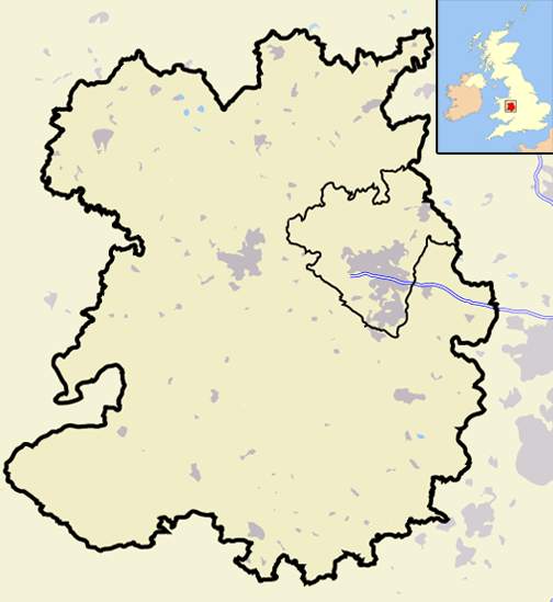
| Popis | A map of the county of Shropshire, England, United Kingdom, showing the post-2009 district boundaries. |
| Dátum | |
| Zdroj | Vlastné dielo |
| Autor | Jhamez84 |
Licencovanie
| Ja, držiteľ autorských práv k tomuto dielu, uvoľňujem toto dielo ako voľné dielo (public domain). Toto platí celosvetovo. V niektorých krajinách to zákon neumožňuje; v tom prípade: Udeľujem komukoľvek právo používať toto dielo na ľubovoľné účely, bez akýchkoľvek podmienok ak také podmienky nevyžaduje zákon. |
História súboru
Po kliknutí na dátum/čas uvidíte ako súbor vyzeral vtedy.
| Dátum/Čas | Náhľad | Rozmery | Používateľ | Komentár | |
|---|---|---|---|---|---|
| aktuálna | 20:06, 19. december 2008 | | 504 × 549 (141 KB) | Jza84 | == Summary == {{Information |Description=A map of the county of Shropshire, England, United Kingdom, showing the post-2009 district boundaries. |Source=self-made |Date=December 2008 |Author= Jhamez84 |Permission=See below |other_versions |
Použitie súboru
Žiadne stránky neobsahujú odkazy na tento súbor.
Globálne využitie súborov
Nasledovné ďalšie wiki používajú tento súbor:
- Použitie na en.wikipedia.org
- Talk:Charles Darwin
- Talk:River Severn
- Crewe and Nantwich
- Talk:Shrewsbury School
- South Shropshire
- Talk:Richard of Shrewsbury, Duke of York
- Ellesmere Port and Neston
- Talk:Shropshire
- Shrewsbury and Atcham
- Talk:Church Stretton
- Castle Morpeth
- Vale Royal
- Blyth Valley
- Wansbeck District
- Tynedale
- Mid Bedfordshire District
- South Bedfordshire
- Penwith
- Kerrier
- Carrick, Cornwall
- Restormel
- Caradon
- North Cornwall
- Teesdale (district)
- Wear Valley
- Derwentside
- North Shropshire
- Kennet District
- West Wiltshire
- North Wiltshire
- Borough of Berwick-upon-Tweed
- Alnwick District
- Bridgnorth District
- Sedgefield (borough)
- Easington District
- Macclesfield (borough)
- Talk:Sheriffhales
- Congleton (borough)
- Chester (district)
- Salisbury District
- Borough of Oswestry
- City of Durham (district)
- Chester-le-Street (district)
- Talk:Weston Lullingfields
- Talk:Ludlow
- Talk:Oswestry School
- Shropshire Wildlife Trust
- Talk:Bridgnorth
- Talk:A. E. Housman
- Talk:Welsh Marches
Zobraziť ďalšie globálne použitie tohto súboru.
.png)
.png)