
Súbor:Piri reis world map 01.jpg

Pôvodný súbor (1 964 × 2 619 pixelov, veľkosť súboru: 7,08 MB, MIME typ: image/jpeg)
Zhrnutie
|
| Popis |
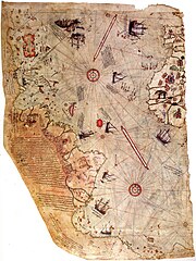
العربية: خارطة العالم بِيد أمير البحار العُثماني حاجي أحمد مُحيي الدين پیري، الشهير باسم پيري ريِّس، رُسمت سنة 1513م. لم يبقَ اليوم سوى نصف الخارطة الأصليَّة، التي يُحتفظ بها في متحف سراي طوپ قاپي في إسطنبول. تجمع هذه الخارطة معلومات من حوالي عشرين خريطة أُخرى، بما فيها إحدى الخرائط التي وضعها كريستوفر كولومبوس بنفسه وخطط فيها سواحل العالم الجديد.
English: Map of the world by Ottoman admiral Piri Reis, drawn in 1513. Only part of the original map survives and is held at the Topkapi Museum in Istanbul. The map synthesizes information from many maps, including one drawn by Christopher Columbus of the Caribbean.
Türkçe: Osmanlı amirali Piri Reis tarafından 1513'te çizilmiş olan, Avrupa ve Afrika'nın batı kıyılarıyla Güney Amerika'nın doğu kıyılarını gösteren dünyanın en eski haritalarından biri olan Piri Reis'in ilk Dünya haritası. |
||||||||||||||||||||
| Dátum | |||||||||||||||||||||
| Zdroj | Library of Topkapi Palace Museum, No. H 1824 Bilkent University (lo res), erisi.com (hi res) | ||||||||||||||||||||
| Autor |
|
||||||||||||||||||||

Licencovanie
|
Toto je věrná fotografická reprodukce původního dvourozměrného uměleckého díla. Ono dílo je samo volným dílem, a to z následujícího důvodu:
Oficiálním stanoviskem nadace Wikimedia Foundation je, že „věrné reprodukce dvourozměrných volných děl jsou také volné a opačná tvrzení jsou útokem na samotný koncept volných děl.“ Podrobnosti naleznete na stránce Commons:When to use the PD-Art tag.
Tato fotografická reprodukce se tedy také považuje za volné dílo. Uvědomte si, že v závislosti na místních zákonech může být další užití tohoto díla ve vaší jurisdikci zakázáno či omezeno. Vizte Commons:Reuse of PD-Art photographs. | ||||
| Annotations | This image is annotated: View the annotations at Commons |
História súboru
Po kliknutí na dátum/čas uvidíte ako súbor vyzeral vtedy.
| Dátum/Čas | Náhľad | Rozmery | Používateľ | Komentár | |
|---|---|---|---|---|---|
| aktuálna | 23:16, 17. júl 2017 | | 1 964 × 2 619 (7,08 MB) | Earthsound | Reverted to version as of 04:00, 17 August 2012 (UTC) The higher resolution images that replaced this are horribly pixelated and have been created by enlarging a much smaller copy. |
| 12:45, 13. november 2016 |  | 3 387 × 4 807 (2,16 MB) | Alonso de Mendoza | color | |
| 13:19, 5. marec 2016 |  | 3 387 × 4 807 (1,6 MB) | ديفيد عادل وهبة خليل 2 | Cropped 5 % horizontally and 5 % vertically using CropTool with precise mode. | |
| 10:37, 23. november 2014 |  | 3 564 × 5 040 (1 019 KB) | Ratzer | higher Resolution 3564 x 5040, source http://www.erisi.com/gelisim/harita/pri/piri_dunya.jpg | |
| 04:00, 17. august 2012 |  | 1 964 × 2 619 (7,08 MB) | FunkMonk | ||
| 02:45, 10. február 2008 |  | 2 000 × 2 753 (2,27 MB) | FunkMonk | {{Information |Description= |Source= |Date= |Author= |Permission= |other_versions= }} | |
| 14:45, 13. september 2006 |  | 829 × 1 087 (205 KB) | InfoCan | rotated previous version of map so North is up. | |
| 07:09, 29. september 2005 |  | 1 087 × 829 (338 KB) | CristianChirita | Piri Reis World Map |
Použitie súboru
Na tento súbor odkazuje nasledujúca stránka:
Globálne využitie súborov
Nasledovné ďalšie wiki používajú tento súbor:
- Použitie na ar.wikipedia.org
- جزر الأنتيل
- بوابة:الدولة العثمانية
- بوابة:الدولة العثمانية/صورة
- ويكيبيديا:صور مختارة/رسومات وجداول وخرائط/خرائط
- بيري ريس
- خريطة بيري ريس
- ويكيبيديا:ترشيحات الصور المختارة/خريطة أحمد محيي الدين امريكا
- ويكيبيديا:صورة اليوم المختارة/مايو 2016
- قالب:صورة اليوم المختارة/2016-05-23
- بوابة:الدولة العثمانية/صورة مختارة/19
- ويكيبيديا:صورة اليوم المختارة/أغسطس 2017
- قالب:صورة اليوم المختارة/2017-08-22
- ويكيبيديا:صورة اليوم المختارة/يوليو 2019
- قالب:صورة اليوم المختارة/2019-07-23
- كتاب الملاحة
- ويكيبيديا:صورة اليوم المختارة/يناير 2022
- قالب:صورة اليوم المختارة/2022-01-15
- Použitie na azb.wikipedia.org
- Použitie na az.wikipedia.org
- Použitie na bg.wikipedia.org
- Použitie na bn.wikipedia.org
- Použitie na ca.wikipedia.org
- Použitie na cbk-zam.wikipedia.org
- Použitie na ckb.wikipedia.org
- Použitie na cs.wikipedia.org
- Použitie na da.wikipedia.org
- Použitie na de.wikipedia.org
- 1513
- Piri Reis
- Karte des Piri Reis
- Antillen
- Entwicklungsgeschichte der Seekarte
- Portal Diskussion:Türkei/Bild der Woche/Kandidaten/Archiv/2008
- Benutzer:DasAugeDerWahrheit
- Portal Diskussion:Türkei/Archiv/2009
- Portal:Türkei/Bild/Archiv
- Charles Hapgood
- Liste historischer Weltkarten
- Theorie der muslimischen Entdeckung Amerikas
Zobraziť ďalšie globálne použitie tohto súboru.