
Súbor:Balkan boundaries1876map1914.png

Pôvodný súbor (984 × 712 pixelov, veľkosť súboru: 73 KB, MIME typ: image/png)

|
This map has been uploaded by Electionworld from en.wikipedia.org to enable the |
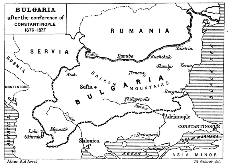
| Popis | Map from "Report of the International Commission To Inquire into the Causes and Conduct of the Balkan Wars" 1914. |
| Dátum | Map printed and published 1914 |
| Zdroj | a map |
| Autor | Source: [1] - JPG to PNG by Iain 09:30, 13 June 2006 (UTC) |
| Povolenie (Využívanie tohto súboru) |
Original File PD |
| Ďalšie verzie | Original Image Image:Balkan boundaries1876map1914.jpg now redundant |
|
Toto dílo je volné také v zemích, jejichž právní řád chrání majetková autorská práva po dobu života autora a 70 let po jeho smrti.
| |
| Tento súbor bol identifikovaný, že nemá žiadne známe obmedzenia vyplývajúce z autorského zákona vrátane všetkých súvisiacich a susedných práv. | |
História súboru
Po kliknutí na dátum/čas uvidíte ako súbor vyzeral vtedy.
| Dátum/Čas | Náhľad | Rozmery | Používateľ | Komentár | |
|---|---|---|---|---|---|
| aktuálna | 22:17, 20. december 2006 | | 984 × 712 (73 KB) | Electionworld | {{ew|en|Iain}} {{Information| |Description = Map from "Report of the International Commission To Inquire into the Causes and Conduct of the Balkan Wars" 1914. |Date = Map printed and published 1914 |Author = Source: [http://www.lib.utexas.edu/maps/histori |
Použitie súboru
Na tento súbor odkazuje nasledujúca stránka:
Globálne využitie súborov
Nasledovné ďalšie wiki používajú tento súbor:
- Použitie na ar.wikipedia.org
- Použitie na bg.wikipedia.org
- Použitie na bs.wikipedia.org
- Použitie na ca.wikipedia.org
- Použitie na de.wikipedia.org
- Použitie na el.wikipedia.org
- Použitie na en.wikipedia.org
- Použitie na et.wikipedia.org
- Použitie na fa.wikipedia.org
- Použitie na fr.wikipedia.org
- Použitie na hr.wikipedia.org
- Použitie na hu.wikipedia.org
- Použitie na it.wikipedia.org
- Použitie na mk.wikipedia.org
- Použitie na nl.wikipedia.org
- Použitie na no.wikipedia.org
- Použitie na pl.wikipedia.org
- Použitie na pt.wikipedia.org
- Použitie na ro.wikipedia.org
- Použitie na simple.wikipedia.org
- Použitie na sq.wikipedia.org
- Použitie na sr.wikipedia.org
- Použitie na tr.wikipedia.org
- Použitie na uk.wikipedia.org
- Použitie na www.wikidata.org