
Súbor:Athenian empire atheight 450 shepherd1923.png

Veľkosť tohto náhľadu: 733 × 600 pixelov. Iné rozlíšenia: 293 × 240 pixelov | 587 × 480 pixelov | 939 × 768 pixelov | 1 094 × 895 pixelov .
Pôvodný súbor (1 094 × 895 pixelov, veľkosť súboru: 2,02 MB, MIME typ: image/png)
Zhrnutie
| Popis |
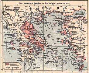
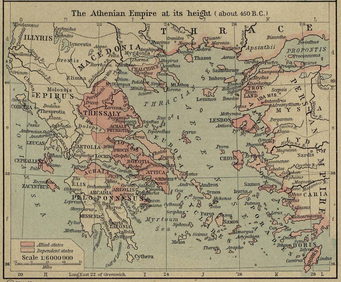
Scan from "Historical Atlas" by William R. Shepherd, New York, Henry Holt and Company, 1926 ed. Original image at the Perry-Castañeda Library Map Collection at the en:University of Texas at Austin website: http://www.lib.utexas.edu/maps/historical/shepherd/athenian_empire_450.jpg From the FAQ @ http://www.lib.utexas.edu/maps/faq.html
This map is not so marked. en:Category:Historical maps by William R. Shepherd |
| Zdroj | William R. Shepherd |
| Autor | William R. Shepherd |
Licencovanie
Toto je volné dílo, neboť bylo vydáno ve Spojených státech mezi roky 1929 a 1977 bez copyrightové výhrady. Pokud není jeho autor již mnoho let mrtev, je stále autorskoprávně chráněno v zemích, které na americká díla neuplatňují pravidlo kratší doby ochrany, jako jsou například Kanada (50 p.m.a.), Čína (50 p.m.a., netýká se Hongkongu či Macaa), Německo (70 p.m.a.), Mexiko (100 p.m.a.), Švýcarsko (70 p.m.a.) a další země s individuálními smlouvami. Více informací najdete v tomto přehledu.
|
 |
Pôvodný záznam nahrávaní
The original description page was here. All following user names refer to en.wikipedia.
- 2006-12-18 22:12 Jengod 1094×895×8 (2117535 bytes) Cleaned up in Elements.
- 2006-12-18 21:31 Jengod 1094×906×8 (1801082 bytes) Scan from "Historical Atlas" by William R. Shepherd, New York, Henry Holt and Company, 1926 ed. Original image at the [http://www.lib.utexas.edu/maps/ Perry-Castañeda Library Map Collection] at the [[University of Texas at Austin]] website: http://www.l
História súboru
Po kliknutí na dátum/čas uvidíte ako súbor vyzeral vtedy.
| Dátum/Čas | Náhľad | Rozmery | Používateľ | Komentár | |
|---|---|---|---|---|---|
| aktuálna | 13:04, 22. február 2007 | | 1 094 × 895 (2,02 MB) | Chewie | {{Information |Description=Scan from "Historical Atlas" by William R. Shepherd, New York, Henry Holt and Company, 1926 ed. Original image at the [http://www.lib.utexas.edu/maps/ Perry-Castañeda Library Map Collection] at the [[:en:University of Texas at |
Použitie súboru
Na tento súbor odkazuje nasledujúca stránka:
Globálne využitie súborov
Nasledovné ďalšie wiki používajú tento súbor:
- Použitie na af.wikipedia.org
- Použitie na ar.wikipedia.org
- Použitie na ca.wikipedia.org
- Použitie na cs.wikipedia.org
- Použitie na en.wikipedia.org
- Použitie na es.wikipedia.org
- Použitie na et.wikipedia.org
- Použitie na hu.wikipedia.org
- Použitie na id.wikipedia.org
- Použitie na it.wikipedia.org
- Použitie na ko.wikipedia.org
- Použitie na nl.wikipedia.org
- Použitie na ru.wikipedia.org
- Použitie na sh.wikipedia.org
- Použitie na sl.wikipedia.org
- Použitie na ta.wikipedia.org
- Použitie na tr.wikipedia.org
- Použitie na zh.wikipedia.org