
Súbor:BNR (Ruthienie Blanche) Map 1918.jpg

Pôvodný súbor (4 400 × 3 015 pixelov, veľkosť súboru: 10,27 MB, MIME typ: image/jpeg)
_Map_1918.jpg)
Zhrnutie
| Titul |
Беларуская: Карта Беларускай Народнай Рэспублікі, 1918 Беларуская (тарашкевіца): Мапа Беларускай Народнай Рэспублікі, 1918
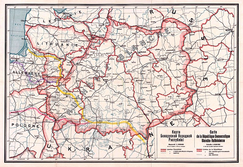
English: Map of the territory claimed by the Belarusian People's Republic (published in 1918).
Русский: Карта Белорусской Народной Республики, 1918
Українська: Карта Білоруської Народної Республіки, 1918 |
| Dátum | |
| Zdroj |
1. Карта БНР 1918 год, IMAGO.BY 2. Originally uploaded to English Wikipedia by Rydel (21:53, 2 January 2005) as en:Image:BNR ruthienie blanche.jpg. |
| Tvorca |
Neznámý |
| Georeferencing | If inappropriate please set warp_status = skip to hide. |
Licencovanie
|
Toto dílo je volné také v zemích, jejichž právní řád chrání majetková autorská práva po dobu života autora a 70 let po jeho smrti.
| |
| Tento súbor bol identifikovaný, že nemá žiadne známe obmedzenia vyplývajúce z autorského zákona vrátane všetkých súvisiacich a susedných práv. | |
História súboru
Po kliknutí na dátum/čas uvidíte ako súbor vyzeral vtedy.
| Dátum/Čas | Náhľad | Rozmery | Používateľ | Komentár | |
|---|---|---|---|---|---|
| aktuálna | 13:56, 26. október 2017 | | 4 400 × 3 015 (10,27 MB) | Kazimier Lachnovič | better quality |
| 14:18, 3. september 2005 |  | 1 000 × 700 (195 KB) | EugeneZelenko | Map of Belarusian National Republic (published in 1918). Originally uploaded to English Wikipedia by Rydel (21:53, 2 January 2005) as en:Image:BNR ruthienie blanche.jpg. Category:Historical maps of Belarus |
Použitie súboru
Na tento súbor odkazujú nasledujúce 2 stránky:
Globálne využitie súborov
Nasledovné ďalšie wiki používajú tento súbor:
- Použitie na ar.wikipedia.org
- Použitie na ast.wikipedia.org
- Použitie na be-tarask.wikipedia.org
- Použitie na be.wikipedia.org
- Použitie na bg.wikipedia.org
- Použitie na ca.wikipedia.org
- Použitie na cs.wikipedia.org
- Použitie na cy.wikipedia.org
- Použitie na da.wikipedia.org
- Použitie na de.wikipedia.org
- Použitie na en.wikipedia.org
- Použitie na eo.wikipedia.org
- Použitie na es.wikipedia.org
- Použitie na et.wikipedia.org
- Použitie na eu.wikipedia.org
- Použitie na fr.wikipedia.org
Zobraziť ďalšie globálne použitie tohto súboru.
_Map_1918.jpg)
_Map_1918.jpg)