
Súbor:Battle of Mount Sorrel - Battle Map - June 6 (restored1).jpg

Pôvodný súbor (1 741 × 2 800 pixelov, veľkosť súboru: 1,94 MB, MIME typ: image/jpeg)
| Popis |
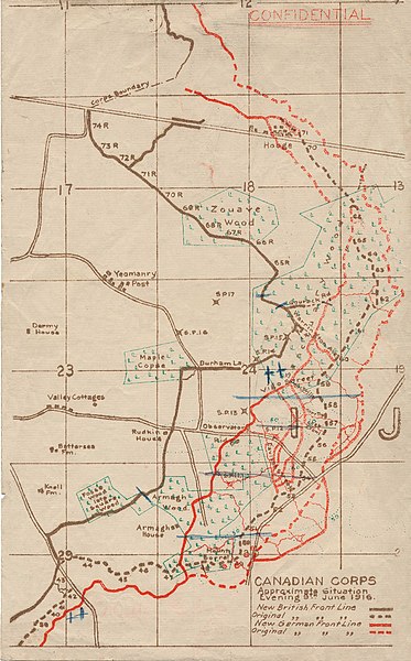
English: This map illustrates the British/Canadian positions (in brown) and the German lines (in red) on 4 June 1916, during the Battle of Mount Sorrel. The Canadians have been driven from several strong points, including Hooge north), Mount Sorrel itself (south), and most of Observatory Ridge (centre). |
|||
| Dátum | ||||
| Zdroj |
George Metcalf Archival Collection, Canadian War Museum: 19870027-018 [1] |
|||
| Autor | n.d. | |||
| Povolenie (Využívanie tohto súboru) |
|
|||
| Ďalšie verzie |
 |

.jpg)
![[1]](http://www.warmuseum.ca/cwm/exhibitions/guerre/photos/2800/19870027-018.jpg)
| Toto je upravený obrázek, což znamená, že byl oproti původní verzi digitálně změněn. Úpravy: Tears, holes and major folds & creases repaired or decreased in intensity..
|
| Pozícia kamery | | Tento a ďalšie obrázky na: OpenStreetMap |
|---|
.jpg¶ms=050.841342_N_0002.948456_E_globe:Earth_type:camera_scale:10000_region:BE_&language=sk)
História súboru
Po kliknutí na dátum/čas uvidíte ako súbor vyzeral vtedy.
| Dátum/Čas | Náhľad | Rozmery | Používateľ | Komentár | |
|---|---|---|---|---|---|
| aktuálna | 21:12, 19. december 2009 | | 1 741 × 2 800 (1,94 MB) | Labattblueboy | {{Information |Description={{en|1=This map illustrates the British/Canadian positions (in brown) and the German lines (in red) on 4 June 1916, during the Battle of Mount Sorrel. The Canadians have been driven from several strong points, including Hooge no |
Použitie súboru
Na tento súbor odkazuje nasledujúca stránka:
Globálne využitie súborov
Nasledovné ďalšie wiki používajú tento súbor:
- Použitie na en.wikipedia.org
- Použitie na fr.wikipedia.org
- Použitie na he.wikipedia.org
- Použitie na nl.wikipedia.org
- Použitie na www.wikidata.org
.jpg)