
Súbor:Berounka (CZE) - location map.svg

Veľkosť tohoto PNG náhľadu tohoto SVG súboru: 800 × 468 pixelov. Iné rozlíšenia: 320 × 187 pixelov | 640 × 374 pixelov | 1 024 × 599 pixelov | 1 280 × 748 pixelov | 2 560 × 1 497 pixelov | 5 342 × 3 123 pixelov .
Pôvodný súbor (SVG súbor, 5 342 × 3 123 pixelov, veľkosť súboru: 143 KB)
_-_location_map.svg)
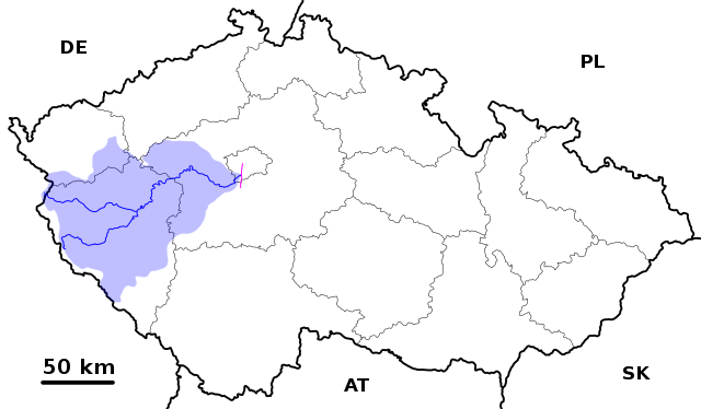
| Popis | The run of the Czech river of Berounka, with its two sources Mže (northern) and Radbuza (southern), until its confluence with the Vltava (magenta) and its watershed |
| Dátum | |
| Zdroj | Vlastné dielo |
| Autor | David Paloch (Caroig) |
| Povolenie (Využívanie tohto súboru) |
Ja, držiteľ autorských práv k tomuto dielu ho týmto zverejňujem za podmienok nasledovnej licencie: Tento súbor podlieha licencii Creative Commons Attribution-Share Alike 2.5 Generic
|
História súboru
Po kliknutí na dátum/čas uvidíte ako súbor vyzeral vtedy.
| Dátum/Čas | Náhľad | Rozmery | Používateľ | Komentár | |
|---|---|---|---|---|---|
| aktuálna | 00:42, 11. november 2007 | | 5 342 × 3 123 (143 KB) | Caroig | no background |
| 10:24, 14. január 2007 |  | 5 342 × 3 123 (144 KB) | Caroig | new version (no boundary on watershed) | |
| 09:36, 14. január 2007 |  | 5 342 × 3 123 (144 KB) | Caroig | lighter watershed version | |
| 09:31, 14. január 2007 |  | 5 342 × 3 123 (144 KB) | Caroig | New version using better template | |
| 13:29, 4. január 2007 |  | 3 417 × 1 956 (175 KB) | Caroig | Commons - location map {{Information | Description = The run of the Czech river of Berounka, with its two sources Mže (northern) and Radbuza (southern), until its confluence with the Vltava (magenta) | Source = Own work (using template [[:Image:(CZE)_te |
Použitie súboru
Globálne využitie súborov
Nasledovné ďalšie wiki používajú tento súbor:
- Použitie na ar.wikipedia.org
- Použitie na cs.wikipedia.org
- Použitie na da.wikipedia.org
- Použitie na de.wikipedia.org
- Použitie na en.wikipedia.org
- Použitie na es.wikipedia.org
- Použitie na fr.wikipedia.org
- Použitie na hr.wikipedia.org
- Použitie na it.wikipedia.org
- Použitie na lld.wikipedia.org
- Použitie na mk.wikipedia.org
- Použitie na nl.wikipedia.org
- Použitie na nn.wikipedia.org
- Použitie na no.wikipedia.org
- Použitie na pl.wikipedia.org
- Použitie na ru.wikipedia.org
- Použitie na sh.wikipedia.org
- Použitie na sr.wikipedia.org
- Použitie na sv.wikipedia.org
- Použitie na www.wikidata.org
_-_location_map.svg)