
Súbor:British Isles.svg

Veľkosť tohoto PNG náhľadu tohoto SVG súboru: 361 × 600 pixelov. Iné rozlíšenia: 144 × 240 pixelov | 289 × 480 pixelov | 462 × 768 pixelov | 616 × 1 024 pixelov | 1 232 × 2 048 pixelov | 1 300 × 2 160 pixelov .
Pôvodný súbor (SVG súbor, 1 300 × 2 160 pixelov, veľkosť súboru: 154 KB)
Zhrnutie
| Popis |
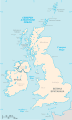
An SVG map of the British Isles, with the largest islands and archipelagos labelled. Always considered part of the British Isles
Sometimes considered part of the British Isles
Other lands |
| Zdroj | Vlastné dielo |
| Autor | Smurrayinchester |
| SVG vývoj | Táto W3C-nevalidná grafika bola vytvorená pomocou iných nástrojov. This map is translated using SVG switch elements: all translations are stored in the same file. |
}
Licencovanie
Ja, držiteľ autorských práv k tomuto dielu ho týmto zverejňujem za podmienok nasledovnej licencie:

|
Bolo udelené povolenie kopírovať, širiť a/alebo meniť tento dokument za podmienok GNU Free Documentation License, verzie 1.2 alebo ktorejkoľvek neskoršej verzie publikovanej Free Software Foundation; bez Nemenných častí, bez Textov na prednej obálke a bez Textov na zadnej obálke. Kópia tejto licencie je zahrnutá v časti nazvanej GNU Free Documentation License. |
| Tento súbor podlieha licencii Creative Commons Attribution-Share Alike 3.0 Unported | ||
| ||
| Táto šablóna licencie bola pridaná k tomuto súboru počas aktualizácie licencovania GFDL. |
Derivative works
-
 македонски
 -
 Flag map (1801–1922)


derivative works
Derivative works of this file: British Isles mk.svg
História súboru
Po kliknutí na dátum/čas uvidíte ako súbor vyzeral vtedy.
| Dátum/Čas | Náhľad | Rozmery | Používateľ | Komentár | |
|---|---|---|---|---|---|
| aktuálna | 15:33, 10. február 2019 | | 1 300 × 2 160 (154 KB) | MSG17 | Uploaded from SVG Translate. |
| 14:56, 13. október 2018 |  | 1 300 × 2 160 (141 KB) | Seb35 | small bug: translations have to be before the default text else the PNG rendering selects the default text | |
| 14:51, 13. október 2018 |  | 1 300 × 2 160 (141 KB) | Seb35 | added French translation | |
| 14:50, 20. máj 2014 |  | 1 300 × 2 160 (135 KB) | NikNaks | More cleaning. File could still be a lot smaller than it currently is | |
| 03:02, 20. máj 2014 |  | 1 300 × 2 160 (152 KB) | NikNaks | Malay translation | |
| 02:36, 20. máj 2014 |  | 1 300 × 2 160 (148 KB) | NikNaks | Cleaning unfortunately lost detail. Will have to return to later | |
| 02:22, 20. máj 2014 |  | 1 297 × 2 160 (37 KB) | NikNaks | Attempting to clean up the file before translation | |
| 12:37, 20. august 2006 |  | 1 297 × 2 160 (196 KB) | Smurrayinchester | An SVG map of the British Isles, with the largest islands and archipelagos labeled. {{legend|#fff0de|Always considered part of the British Isles|border=#ffffff}} {{legend|#ffb380|Sometimes considered part of the British Isles|border=#ffffff}} {{legend|#e |
Použitie súboru
Žiadne stránky neobsahujú odkazy na tento súbor.
Globálne využitie súborov
Nasledovné ďalšie wiki používajú tento súbor:
- Použitie na ar.wikipedia.org
- Použitie na az.wikipedia.org
- Použitie na be.wikipedia.org
- Použitie na bs.wikipedia.org
- Použitie na ceb.wikipedia.org
- Použitie na ckb.wikipedia.org
- Použitie na da.wikipedia.org
- Použitie na en.wikipedia.org
- Geography of the Isle of Man
- Burhou
- Talk:International Football Association Board
- Module:Location map/data/British Isles/doc
- List of offshore wind farms in the Irish Sea
- Siege of St Andrews Castle
- User:Malpass93/sandbox
- Module:Location map/data/British Isles
- 2014 Senior Open Championship
- 2017 Senior Open Championship
- 2018 Eisenhower Trophy
- User:Grover cleveland/History of the laws of the game/List of IFAB meetings
- User:Grover cleveland/English managers
- 2018 Espirito Santo Trophy
- 1965 European Amateur Team Championship
- 1975 European Amateur Team Championship
- 1981 European Amateur Team Championship
- 1989 European Amateur Team Championship
- 1997 European Amateur Team Championship
- 2005 European Amateur Team Championship
- 2007 European Amateur Team Championship
- 2009 European Amateur Team Championship
- 1971 European Ladies' Team Championship
- 1979 European Ladies' Team Championship
- 1987 European Ladies' Team Championship
- 1991 European Ladies' Team Championship
- 2013 European Ladies' Team Championship
- 2021 European Ladies' Team Championship
- 2022 European Amateur Team Championship
- 2022 European Ladies' Team Championship
- 2013 Senior Open Championship
- 2012 Senior Open Championship
- 2011 Senior Open Championship
- 2008 Senior Open Championship
- 2006 Senior Open Championship
- 2002 Senior British Open
- 2001 Senior British Open
- 2000 Senior British Open
- 2022 Senior Open Championship
- User:Erik Sergeant/sandbox 2
- 2023 Senior Open Championship
- Module:Location map/data/British Isles/sandbox
- Draft:2024 Monoposto Championship
Zobraziť ďalšie globálne použitie tohto súboru.