
Súbor:CapeHornDetailMap.png
Veľkosť tohto náhľadu: 800 × 482 pixelov. Iné rozlíšenia: 320 × 193 pixelov | 640 × 386 pixelov | 906 × 546 pixelov .
Pôvodný súbor (906 × 546 pixelov, veľkosť súboru: 91 KB, MIME typ: image/png)
Zhrnutie
| Popis |
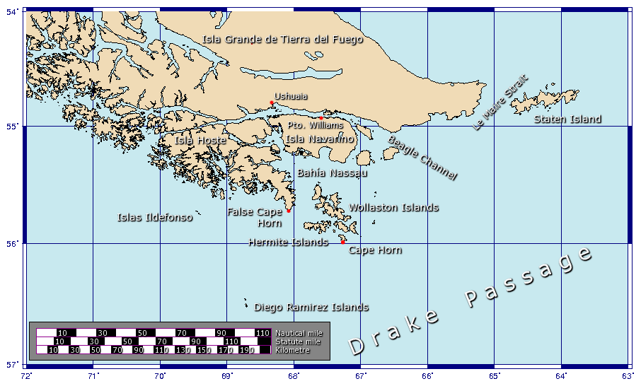
Español: Detalle de las islas cerca del Cabo de Hornos
Generated using GMT. |
| Dátum | 27. januára 2006 (datum prvotního načtení souboru) |
| Zdroj | Vlastné dielo |
| Autor | Johantheghost |
Licencovanie
Ja, držiteľ autorských práv k tomuto dielu ho týmto zverejňujem za podmienok nasledovných licencií:

|
Bolo udelené povolenie kopírovať, širiť a/alebo meniť tento dokument za podmienok GNU Free Documentation License, verzie 1.2 alebo ktorejkoľvek neskoršej verzie publikovanej Free Software Foundation; bez Nemenných častí, bez Textov na prednej obálke a bez Textov na zadnej obálke. Kópia tejto licencie je zahrnutá v časti nazvanej GNU Free Documentation License. |
| Tento súbor podlieha licencii Creative Commons Attribution-Share Alike 3.0 Unported | ||
| ||
| Táto šablóna licencie bola pridaná k tomuto súboru počas aktualizácie licencovania GFDL. |
Tento súbor je licencovaný za podmienok Creative Commons Attribution-Share Alike 2.5 Generic, 2.0 Generic a 1.0 Generic.
- Môžete slobodne:
- zdieľať – kopírovať, šíriť a prenášať dielo
- meniť ho – upravovať dielo
- Za nasledovných podmienok:
- uvedenie autorov – Musíte spomenúť autorov (jednotlivo alebo kolektívne), poskytnúť odkaz na licenciu a uviesť, či ste niečo zmenili. Môžete to urobiť ľubovoľným primeraným spôsobom, ale nie spôsobom naznačujúcim, že poskytovateľ licencie podporuje vás alebo vaše použitie diela.
- meniť za rovnakých podmienok – Ak toto dielo zmeníte, prevediete do inej formy alebo použijete ako základ iného diela, musíte výsledok šíriť pod rovnakou alebo kompatibilnou licenciou ako originál.
Môžete si zvoliť ľubovolnú z týchto licencií.
História súboru
Po kliknutí na dátum/čas uvidíte ako súbor vyzeral vtedy.
| Dátum/Čas | Náhľad | Rozmery | Používateľ | Komentár | |
|---|---|---|---|---|---|
| aktuálna | 16:17, 21. november 2009 | | 906 × 546 (91 KB) | Botaurus | functionless line (borderline) removed |
| 12:22, 9. február 2006 |  | 906 × 546 (91 KB) | Johantheghost | Less violent colours. | |
| 00:25, 28. január 2006 |  | 906 × 546 (90 KB) | Johantheghost | Fix scale! | |
| 20:20, 27. január 2006 |  | 906 × 546 (87 KB) | Johantheghost | Scale and false cape | |
| 16:34, 27. január 2006 |  | 906 × 546 (81 KB) | Johantheghost | A map showing the location of Cape Horn, including part of the Drake Passage. Generated using [http://gmt.soest.hawaii.edu/ GMT]. |
Použitie súboru
Na tento súbor odkazuje nasledujúca stránka:
Globálne využitie súborov
Nasledovné ďalšie wiki používajú tento súbor:
- Použitie na af.wikipedia.org
- Použitie na als.wikipedia.org
- Použitie na ar.wikipedia.org
- Použitie na ast.wikipedia.org
- Použitie na az.wikipedia.org
- Použitie na be-tarask.wikipedia.org
- Použitie na be.wikipedia.org
- Použitie na bg.wikipedia.org
- Použitie na br.wikipedia.org
- Použitie na bs.wikipedia.org
- Použitie na ca.wikipedia.org
- Použitie na ceb.wikipedia.org
- Použitie na ckb.wikipedia.org
- Použitie na cy.wikipedia.org
- Použitie na da.wikipedia.org
- Použitie na de.wikipedia.org
- Použitie na el.wikipedia.org
- Použitie na en.wikipedia.org
- Použitie na eo.wikipedia.org
- Použitie na es.wikipedia.org
- Použitie na et.wikipedia.org
- Použitie na eu.wikipedia.org
- Použitie na fa.wikipedia.org
- Použitie na fi.wikipedia.org
- Použitie na frr.wikipedia.org
- Použitie na fr.wikipedia.org
Zobraziť ďalšie globálne použitie tohto súboru.