
Súbor:Empire akkad.svg

Pôvodný súbor (SVG súbor, 1 475 × 1 149 pixelov, veľkosť súboru: 2,34 MB)
Zhrnutie

|
This SVG file contains embedded text that can be translated into your language, using any capable SVG editor, text editor or the SVG Translate tool. For more information see: About translating SVG files. |
| Popis |
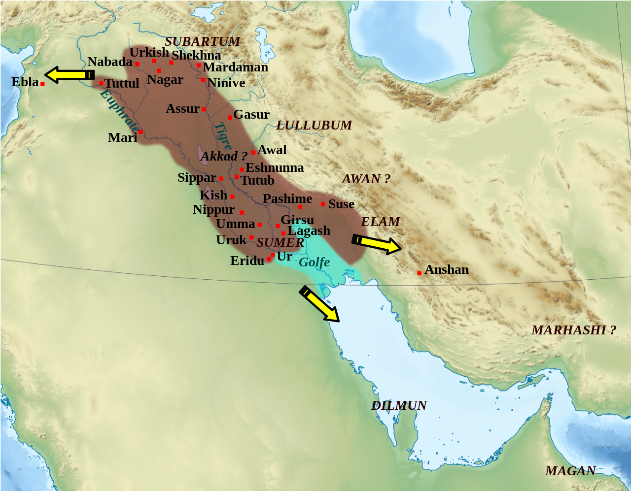
English: Mapa que mostra l'extensió aproximada de l'imperi Accadi durant el regnat de Narâm-Sîn (2254-2218 a.C. en la cronologia breu). Français : Carte de l'extension approximative de l'empire d'Akkad sous le règne de Narâm-Sîn (2254-2218 av. J.-C. selon la chronologie moyenne), et des directions des campagnes militaires extérieures. Sources : B. Lafont et M. Sauvage dans M. Sauvage (dir.), Atlas historique du Proche-Orient ancien, Paris, Les Belles Lettres, 2020, p. 70 ; P. Michalowski, « The Kingdom of Akkad in Contact with the World », dans The Oxford History of the Ancient Near East, Volume 1: From the Beginnings to Old Kingdom Egypt and the Dynasty of Akkad, New York, Oxford University Press, 2020, p. 688 fig. 10.1. |
| Dátum | (UTC) |
| Zdroj | |
| Autor |
|
| Ďalšie verzie |
File:Empire akkad.svg has 2 translations.
Other related versions: []
|


| Pozícia kamery | | Tento a ďalšie obrázky na: OpenStreetMap |
|---|
|
|
This SVG file contains embedded text that can be translated into your language, using any capable SVG editor, text editor or the SVG Translate tool. For more information see: About translating SVG files. |
This file is translated using SVG <switch> elements. All translations are stored in the same file! Learn more.
For most Wikipedia projects, you can embed the file normally (without a To translate the text into your language, you can use the SVG Translate tool. Alternatively, you can download the file to your computer, add your translations using whatever software you're familiar with, and re-upload it with the same name. You will find help in Graphics Lab if you're not sure how to do this. |
| Toto je upravený obrázek, což znamená, že byl oproti původní verzi digitálně změněn. Úpravy: Ajout des villes, du contour approximatif de l'empire.. Původní verzi je možné zhlédnout zde: Middle East topographic map-blank.svg. Úpravy provedl Zunkir.
|
Licencovanie
- Môžete slobodne:
- zdieľať – kopírovať, šíriť a prenášať dielo
- meniť ho – upravovať dielo
- Za nasledovných podmienok:
- uvedenie autorov – Musíte spomenúť autorov (jednotlivo alebo kolektívne), poskytnúť odkaz na licenciu a uviesť, či ste niečo zmenili. Môžete to urobiť ľubovoľným primeraným spôsobom, ale nie spôsobom naznačujúcim, že poskytovateľ licencie podporuje vás alebo vaše použitie diela.
- meniť za rovnakých podmienok – Ak toto dielo zmeníte, prevediete do inej formy alebo použijete ako základ iného diela, musíte výsledok šíriť pod rovnakou alebo kompatibilnou licenciou ako originál.

|
Bolo udelené povolenie kopírovať, širiť a/alebo meniť tento dokument za podmienok GNU Free Documentation License, verzie 1.2 alebo ktorejkoľvek neskoršej verzie publikovanej Free Software Foundation; bez Nemenných častí, bez Textov na prednej obálke a bez Textov na zadnej obálke. Kópia tejto licencie je zahrnutá v časti nazvanej GNU Free Documentation License. |
Pôvodný záznam nahrávaní
This image is a derivative work of the following images:
- File:Middle_East_topographic_map-blank.svg licensed with Cc-by-sa-3.0,2.5,2.0,1.0, GFDL
- 2010-11-03T17:52:56Z Sémhur 3097x1938 (10510751 Bytes) == {{int:filedesc}} == {{Information |Description={{Multilingual description |en= Blank physical map of the [[:en:Middle East|Middle East]] |fr= Carte physique vierge du [[:fr:Moyen-Orient|Moyen-Orient]]. }} |Source={{own}}.
Uploaded with derivativeFX
História súboru
Po kliknutí na dátum/čas uvidíte ako súbor vyzeral vtedy.
| Dátum/Čas | Náhľad | Rozmery | Používateľ | Komentár | |
|---|---|---|---|---|---|
| aktuálna | 01:21, 19. február 2024 | | 1 475 × 1 149 (2,34 MB) | Manlleus | File uploaded using svgtranslate tool (https://svgtranslate.toolforge.org/). Added translation for ca. |
| 14:42, 6. máj 2023 |  | 1 475 × 1 149 (2,32 MB) | Zunkir | + Awal | |
| 17:18, 11. marec 2023 |  | 1 475 × 1 149 (2,32 MB) | Zunkir | taille police | |
| 16:58, 11. marec 2023 |  | 1 475 × 1 149 (2,32 MB) | Zunkir | contours, villes | |
| 11:49, 29. október 2011 |  | 1 475 × 1 149 (2,33 MB) | Zunkir | Police. | |
| 20:32, 28. október 2011 |  | 1 475 × 1 149 (2,32 MB) | Zunkir | Reverted to version as of 10:06, 7 January 2011 | |
| 20:31, 28. október 2011 |  | 1 475 × 1 149 (2,33 MB) | Zunkir | Police. | |
| 10:06, 7. január 2011 |  | 1 475 × 1 149 (2,32 MB) | Sémhur | Remove coloured boxes | |
| 22:31, 11. november 2010 |  | 1 475 × 1 149 (2,33 MB) | Zunkir | New new try | |
| 22:13, 11. november 2010 |  | 1 475 × 1 149 (2,33 MB) | Zunkir | Again ... |
Použitie súboru
Na tento súbor odkazujú nasledujúce 2 stránky:
Globálne využitie súborov
Nasledovné ďalšie wiki používajú tento súbor:
- Použitie na af.wikipedia.org
- Použitie na ar.wikipedia.org
- Použitie na arz.wikipedia.org
- Použitie na ast.wikipedia.org
- Použitie na azb.wikipedia.org
- Použitie na az.wikipedia.org
- Použitie na bg.wikipedia.org
- Použitie na bn.wikipedia.org
- Použitie na br.wikipedia.org
- Použitie na bs.wikipedia.org
- Použitie na ca.wikipedia.org
- Použitie na ckb.wikipedia.org
- Použitie na cs.wikipedia.org
- Použitie na da.wikipedia.org
- Použitie na el.wikipedia.org
- Použitie na en.wikipedia.org
- Akkadian Empire
- Shar-Kali-Sharri
- Gutian rule in Mesopotamia
- Naram-Sin of Akkad
- List of conflicts in Asia
- History of Mesopotamia
- Middle Eastern empires
- Rimush
- User:RekonDog/Sandbox
- Sargon of Akkad
- User:RekonDog/sandbox
- Armi (Syria)
- Akkad (city)
- User:History of Persia/sandbox
- User:Monochrome Monitor/Under Construction
- Early Assyrian period
- King of the Universe
- King of Sumer and Akkad
- Abalgamash
- User:SomeGuyWhoRandomlyEdits/History of Sumer
Zobraziť ďalšie globálne použitie tohto súboru.