
Súbor:Madhhab Map2.png
Veľkosť tohto náhľadu: 800 × 388 pixelov. Iné rozlíšenia: 320 × 155 pixelov | 640 × 310 pixelov | 1 245 × 604 pixelov .
Pôvodný súbor (1 245 × 604 pixelov, veľkosť súboru: 50 KB, MIME typ: image/png)

|
Tento obrázek (skupina religion map) by měl být vytvořen pomocí vektorové grafiky jako SVG soubor. To má několik výhod; podrobnosti najdete na stránce Commons:Media for cleanup. Je-li SVG verze tohoto obrázku již k dispozici, prosím nahrajte ji. Po nahrání nahraďte tuto šablonu šablonou {{Vector version available|jméno nového obrázku.svg}}.
|
Zhrnutie
| Popis |
العربية: المدارس الفقهية الإسلامية الرئيسيّة وانتشارها حول العالم (لغة إنجليزية)
فارسی: نقشهٔ پراکندگی مذاهب فقهی اسلام در جهان (انگلیسی)
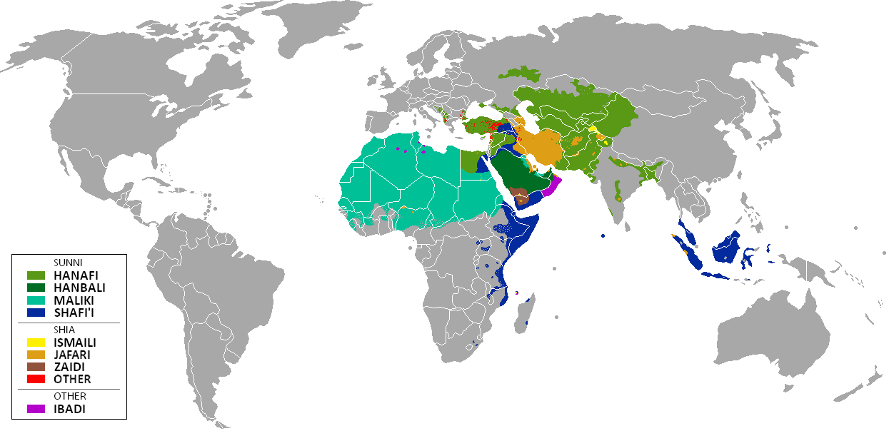
English: The distribution of the predominant Islamic madhhab (school of law) followed in majority-Muslim countries and regions (English)
Bahasa Indonesia: Distribusi penyebaran agama islam berdasarkan Mahdab di negara-negara dan wilayah dunia |
| Dátum | |
| Zdroj | Own work by uploader from a blank-map, based on this source: Legal Sources and various other sources |
| Autor | Ghibar |
| Ďalšie verzie |
Derivative works of this file: |
Licencovanie
Ja, držiteľ autorských práv k tomuto dielu ho týmto zverejňujem za podmienok nasledovných licencií:
Tento súbor podlieha licencii Creative Commons Attribution-Share Alike 3.0 Unported
- Môžete slobodne:
- zdieľať – kopírovať, šíriť a prenášať dielo
- meniť ho – upravovať dielo
- Za nasledovných podmienok:
- uvedenie autorov – Musíte spomenúť autorov (jednotlivo alebo kolektívne), poskytnúť odkaz na licenciu a uviesť, či ste niečo zmenili. Môžete to urobiť ľubovoľným primeraným spôsobom, ale nie spôsobom naznačujúcim, že poskytovateľ licencie podporuje vás alebo vaše použitie diela.
- meniť za rovnakých podmienok – Ak toto dielo zmeníte, prevediete do inej formy alebo použijete ako základ iného diela, musíte výsledok šíriť pod rovnakou alebo kompatibilnou licenciou ako originál.

|
Bolo udelené povolenie kopírovať, širiť a/alebo meniť tento dokument za podmienok GNU Free Documentation License, verzie 1.2 alebo ktorejkoľvek neskoršej verzie publikovanej Free Software Foundation; bez Nemenných častí, bez Textov na prednej obálke a bez Textov na zadnej obálke. Kópia tejto licencie je zahrnutá v časti nazvanej GNU Free Documentation License. |
Môžete si zvoliť ľubovolnú z týchto licencií.
| Annotations | This image is annotated: View the annotations at Commons |
História súboru
Po kliknutí na dátum/čas uvidíte ako súbor vyzeral vtedy.
| Dátum/Čas | Náhľad | Rozmery | Používateľ | Komentár | |
|---|---|---|---|---|---|
| aktuálna | 11:24, 23. január 2018 | | 1 245 × 604 (50 KB) | Maphobbyist | Revert. Jafari school more widespread in northern Sumatra according to sources, than mere dots. |
| 11:55, 30. máj 2016 |  | 1 245 × 604 (2,87 MB) | Riyantojayadi | Madhhab majority of Aceh region[1] and West Sumatra/Minangkabau region[2] in Indonesia are Syafii school of Sunni. There are some tribe's ritual in this area that are based on Shia such tabot, however, for religion, they are practicing . Shia communiti... | |
| 13:45, 11. január 2015 |  | 1 245 × 604 (50 KB) | AnonMoos | Reverted to version as of 02:11, 30 July 2014 -- see User_talk:Peaceworld111 | |
| 10:24, 11. január 2015 |  | 1 245 × 604 (52 KB) | Peaceworld111 | Re-added Ahmadi. It's a sect of Islam per reliable sources and is not a mere dot. See talk page. | |
| 02:10, 11. január 2015 |  | 1 245 × 604 (50 KB) | AnonMoos | Reverted to version as of 02:11, 30 July 2014 -- change not discussed on image talk page, possibly problematic, see user talk page | |
| 18:11, 8. január 2015 |  | 1 245 × 604 (52 KB) | Peaceworld111 | Added Ahmadi | |
| 02:11, 30. júl 2014 |  | 1 245 × 604 (50 KB) | KronosLine | Fixed Russia | |
| 18:36, 20. júl 2014 |  | 1 245 × 604 (63 KB) | Calthinus | distribution of Bektashis in Albania fixed, distribution of Muslims in Greece & Macedonia (esp the ethnic Slav Macedonian Muslims, whose distribution had previously not been marked) fixed, various other fixes... | |
| 17:50, 19. október 2013 |  | 1 245 × 604 (50 KB) | Hibernian | Damn it, that revert button doesn't do what I thought it does. Here's what I meant to change it to. This version also changes the Kerala Muslims to Shafi'i as was suggested on the talk page. | |
| 17:37, 19. október 2013 |  | 1 245 × 604 (55 KB) | Hibernian | Reverted to previous version. It is totally illogical to not show the borders of states with limited recognition (practically every map on Wikipedia depicts these entities), it has nothing to do with the official UN definitions, but with showing reality. |
Použitie súboru
Žiadne stránky neobsahujú odkazy na tento súbor.
Globálne využitie súborov
Nasledovné ďalšie wiki používajú tento súbor:
- Použitie na bn.wikipedia.org
- Použitie na bn.wikivoyage.org
- Použitie na en.wikipedia.org
- Použitie na en.wikivoyage.org
- Použitie na he.wikipedia.org
- Použitie na hi.wikivoyage.org
- Použitie na id.wikipedia.org
- Použitie na incubator.wikimedia.org
- Použitie na it.wikivoyage.org
- Použitie na ja.wikipedia.org
- Použitie na mzn.wikipedia.org
- Použitie na uk.wikipedia.org