
Súbor:Mexico cartel map May 2010.svg

Veľkosť tohoto PNG náhľadu tohoto SVG súboru: 800 × 544 pixelov. Iné rozlíšenia: 320 × 218 pixelov | 640 × 435 pixelov | 1 024 × 696 pixelov | 1 280 × 870 pixelov | 2 560 × 1 741 pixelov | 1 000 × 680 pixelov .
Pôvodný súbor (SVG súbor, 1 000 × 680 pixelov, veľkosť súboru: 193 KB)
| Popis |
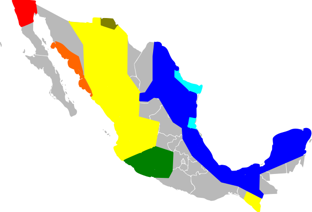
English: An approximate map of the areas held by various Mexican cartels. This map was generated using the information at [1], based on [2] (STRATFOR report dated May 17, 2010). Some points from that map were roughly located and used to draw line segments, from which the territories were filled. Note that the method of simply sampling individual location datapoints from a map precludes all possibility of copyright, and my experience trying to control Inkscape was so poor I feel like I couldn't violate copyright with it if I wanted to! Red = Tijuana/Arellano Felix, Orange = Beltran Leyva, Yellow=Sinaloa, Green=La Familia/Michoacan, Brown=Carillo Fuentes, Cyan=Gulf Cartel/New Federation, Blue=Zetas. Note that this data was likely never very reliable, has been further degraded by my method of redrawing the map, and is surely out of date as of the time I uploaded it. Last but not least, be warned this Inkscape monstrosity may not act like proper svg and could end up not displaying the way it did on my screen. |
| Dátum | (UTC) |
| Zdroj | |
| Autor |
|
![[1]](http://www.wickenburg-az.com/wp-content/uploads/2010/11/Smuggling_1-4.jpg)
Ja, držiteľ autorských práv k tomuto dielu ho týmto zverejňujem za podmienok nasledovných licencií:
Tento súbor podlieha licencii Creative Commons Attribution-Share Alike 3.0 Unported
- Môžete slobodne:
- zdieľať – kopírovať, šíriť a prenášať dielo
- meniť ho – upravovať dielo
- Za nasledovných podmienok:
- uvedenie autorov – Musíte spomenúť autorov (jednotlivo alebo kolektívne), poskytnúť odkaz na licenciu a uviesť, či ste niečo zmenili. Môžete to urobiť ľubovoľným primeraným spôsobom, ale nie spôsobom naznačujúcim, že poskytovateľ licencie podporuje vás alebo vaše použitie diela.
- meniť za rovnakých podmienok – Ak toto dielo zmeníte, prevediete do inej formy alebo použijete ako základ iného diela, musíte výsledok šíriť pod rovnakou alebo kompatibilnou licenciou ako originál.

|
Bolo udelené povolenie kopírovať, širiť a/alebo meniť tento dokument za podmienok GNU Free Documentation License, verzie 1.2 alebo ktorejkoľvek neskoršej verzie publikovanej Free Software Foundation; bez Nemenných častí, bez Textov na prednej obálke a bez Textov na zadnej obálke. Kópia tejto licencie je zahrnutá v časti nazvanej GNU Free Documentation License. |
Môžete si zvoliť ľubovolnú z týchto licencií.
Pôvodný záznam nahrávaní
This image is a derivative work of the following images:
- File:Mexico_Map.svg licensed with Cc-by-sa-3.0, GFDL
- 2009-04-27T09:22:54Z Allstrak 1000x680 (151067 Bytes) {{Information |Description={{en|1=a gray map of the states of Mexico to use as template for other Maps}} {{nl|1=een grijze kaart van de staten van Mexico om te gebruiken als 'template' om ander kaarten op te bazeren}} |Source
Uploaded with derivativeFX
História súboru
Po kliknutí na dátum/čas uvidíte ako súbor vyzeral vtedy.
| Dátum/Čas | Náhľad | Rozmery | Používateľ | Komentár | |
|---|---|---|---|---|---|
| aktuálna | 09:03, 21. marec 2011 | | 1 000 × 680 (193 KB) | Wnt | {{Information |Description={{en|1=An approximate map of the areas held by various Mexican cartels. This map was generated using the information at [http://www.wickenburg-az.com/wp-content/uploads/2010/11/Smuggling_1-4.jpg], based on [http://www.stratfor. |
Použitie súboru
Na tento súbor odkazuje nasledujúca stránka:
Globálne využitie súborov
Nasledovné ďalšie wiki používajú tento súbor:
- Použitie na af.wikipedia.org
- Použitie na ast.wikipedia.org
- Použitie na cs.wikipedia.org
- Použitie na en.wikipedia.org
- Použitie na es.wikipedia.org
- Použitie na eu.wikipedia.org
- Použitie na hy.wikipedia.org
- Použitie na it.wikipedia.org
- Použitie na ja.wikipedia.org
- Použitie na ka.wikipedia.org
- Použitie na ko.wikipedia.org
- Použitie na pl.wikipedia.org
- Použitie na ro.wikipedia.org
- Použitie na ru.wikipedia.org
- Použitie na ru.wikinews.org
- Použitie na sr.wikipedia.org
- Použitie na tr.wikipedia.org
- Použitie na uk.wikipedia.org