
Súbor:MiG Alley Map.JPG
Nie je dostupné vyššie rozlíšenie.
MiG_Alley_Map.JPG (348 × 375 pixelov, veľkosť súboru: 52 KB, MIME typ: image/jpeg)
Zhrnutie

|
K tomuto obrázku existuje vektorová verzia (v SVG).
Ak je lepšia, používajte radšej tú. File:MiG Alley Map.JPG → File:MiG Alley Map (en).svg
Podrobnejšie informácie o vektorovej grafike nájdete na stránke Commons:Transition to SVG. Taktiež si môžete prečítať informácie o podpore formátu SVG v MediaWiki. |
.svg) |
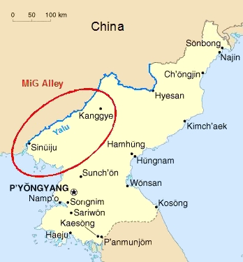
| Popis |
Deutsch: Das Gebiet an der chinesisch-nordkoreanischen Grenze, das während des Koreakrieges (1950-53) als "MiG Alley" berühmt wurde.
English: The area called "MiG Alley" during the Korean War (1950-53) on the Chinese-North Korean border. |
| Dátum | 01.06.2006 |
| Zdroj | Vlastné dielo based on CIA Factbook map on North Korea |
| Autor | Triggerhappy |
| Ďalšie verzie |
Chinese: Russian: Russian: |
Licencovanie
| Ja, držiteľ autorských práv k tomuto dielu, uvoľňujem toto dielo ako voľné dielo (public domain). Toto platí celosvetovo. V niektorých krajinách to zákon neumožňuje; v tom prípade: Udeľujem komukoľvek právo používať toto dielo na ľubovoľné účely, bez akýchkoľvek podmienok ak také podmienky nevyžaduje zákon. |
História súboru
Po kliknutí na dátum/čas uvidíte ako súbor vyzeral vtedy.
| Dátum/Čas | Náhľad | Rozmery | Používateľ | Komentár | |
|---|---|---|---|---|---|
| aktuálna | 20:09, 27. január 2012 | | 348 × 375 (52 KB) | Hohum | Cleanup |
| 17:27, 1. jún 2006 |  | 348 × 375 (21 KB) | Triggerhappy | {{Information |Description=*'''de:''' Das Gebiet an der chinesisch-nordkoreanischen Grenze, das während des Koreakrieges (1950-53) als "MiG Alley" berühmt wurde. *'''en:''' The area called "MiG Alley" during the Korean War (1950-53) on the chinese-north |
Použitie súboru
Žiadne stránky neobsahujú odkazy na tento súbor.
Globálne využitie súborov
Nasledovné ďalšie wiki používajú tento súbor:
- Použitie na zh.wikipedia.org