
Súbor:Political map of England 1153.PNG

Veľkosť tohto náhľadu: 509 × 599 pixelov. Iné rozlíšenia: 204 × 240 pixelov | 408 × 480 pixelov | 652 × 768 pixelov | 870 × 1 024 pixelov | 1 489 × 1 753 pixelov .
Pôvodný súbor (1 489 × 1 753 pixelov, veľkosť súboru: 217 KB, MIME typ: image/png)

|
K tomuto obrázku existuje vektorová verzia (v SVG).
Ak je lepšia, používajte radšej tú. File:Political map of England 1153.PNG → File:Political map of England 1153.svg
Podrobnejšie informácie o vektorovej grafike nájdete na stránke Commons:Transition to SVG. Taktiež si môžete prečítať informácie o podpore formátu SVG v MediaWiki. |
 |
Zhrnutie
| Popis |
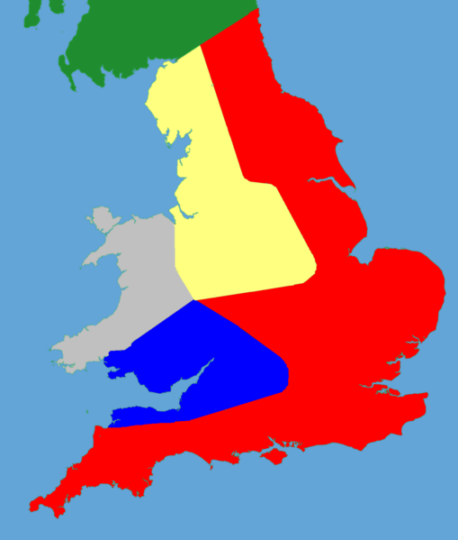
English: A political map of southern Britain in 1153 |
| Dátum | (UTC) |
| Zdroj |
Vlastní dílo pomocí:
|
| Autor |
|
| Toto je upravený obrázek, což znamená, že byl oproti původní verzi digitálně změněn. Úpravy: Trimmed and historical details added. Původní verzi je možné zhlédnout zde: Gb4dot.svg. Úpravy provedl Hchc2009.
|
Ja, držiteľ autorských práv k tomuto dielu ho týmto zverejňujem za podmienok nasledovnej licencie:
| Ja, držiteľ autorských práv k tomuto dielu, uvoľňujem toto dielo ako voľné dielo (public domain). Toto platí celosvetovo. V niektorých krajinách to zákon neumožňuje; v tom prípade: Udeľujem komukoľvek právo používať toto dielo na ľubovoľné účely, bez akýchkoľvek podmienok ak také podmienky nevyžaduje zákon. |
Pôvodný záznam nahrávaní
This image is a derivative work of the following images:
- File:Gb4dot.svg licensed with PD-self
Uploaded with derivativeFX
História súboru
Po kliknutí na dátum/čas uvidíte ako súbor vyzeral vtedy.
| Dátum/Čas | Náhľad | Rozmery | Používateľ | Komentár | |
|---|---|---|---|---|---|
| aktuálna | 18:03, 27. máj 2011 | | 1 489 × 1 753 (217 KB) | Hchc2009 | {{Information |Description=A blank locator map for Great Britain. The idea is to superimpose Image:dot4gb.svg at the appropriate point. See w:Template:GBthumb for code to do this. These two images can replace any locator map posted by Lupin - se |
Použitie súboru
Na tento súbor odkazuje nasledujúca stránka:
Globálne využitie súborov
Nasledovné ďalšie wiki používajú tento súbor:
- Použitie na da.wikipedia.org
- Použitie na fr.wikipedia.org
- Použitie na hu.wikipedia.org
- Použitie na it.wikipedia.org
- Použitie na no.wikipedia.org
- Použitie na pt.wikipedia.org
- Použitie na ru.wikipedia.org
- Použitie na tr.wikipedia.org