
Súbor:SouthEast Europe 1878.jpg

Veľkosť tohto náhľadu: 800 × 563 pixelov. Iné rozlíšenia: 320 × 225 pixelov | 640 × 450 pixelov | 1 024 × 721 pixelov | 1 280 × 901 pixelov | 1 739 × 1 224 pixelov .
Pôvodný súbor (1 739 × 1 224 pixelov, veľkosť súboru: 2,14 MB, MIME typ: image/jpeg)
Zhrnutie
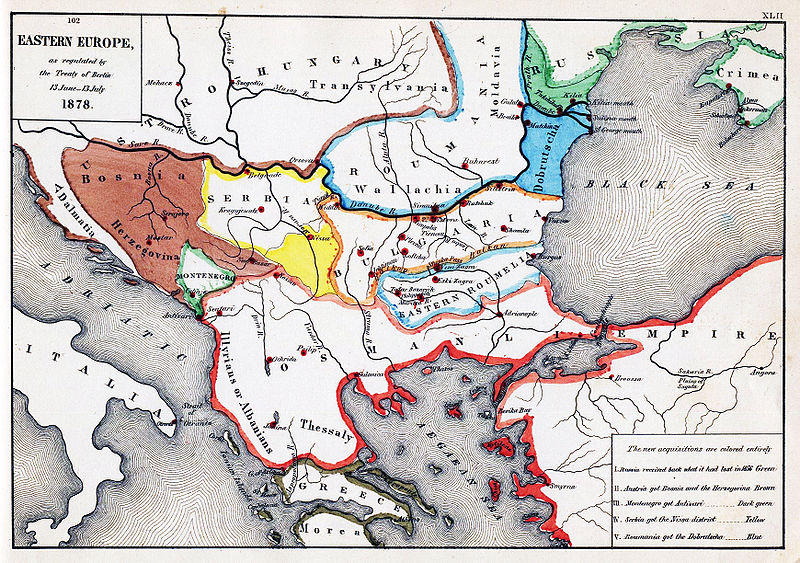
| Popis | Map of South-Eastern Europe after the Congress of Berlin, 1878 |
| Dátum | |
| Zdroj | Map from "An Historical Atlas" by Robert H. Labberton, E. Elaxton and Co., 1884. |
| Autor | Robert H. Labberton, E. Elaxton and Co. |
| Povolenie (Využívanie tohto súboru) |
PD-old |
Licencovanie
Toto dílo je ve Spojených státech volným dílem. To platí pro americká díla, jejichž autorská práva vypršela, často proto, že byla poprvé zveřejněna před 1. lednem 1929. Podívejte se na tuto stránku pro další vysvětlení.
|
 | |
 |
Tento obrázek nemusí být volným dílem mimo Spojené státy; to se týká zvláště těch zemí a oblastí, kde pro americká díla neplatí pravidlo kratší doby, jako jsou Kanada, Kontinentální Čína (ne Hong Kong nebo Macao), Německo, Mexiko a Švýcarsko. Tvůrce a rok publikace jsou nezbytné informace a musí být uvedeny. Viz Wikipedie:Autorské právo pro více informací.
|
História súboru
Po kliknutí na dátum/čas uvidíte ako súbor vyzeral vtedy.
| Dátum/Čas | Náhľad | Rozmery | Používateľ | Komentár | |
|---|---|---|---|---|---|
| aktuálna | 15:35, 11. máj 2010 | | 1 739 × 1 224 (2,14 MB) | PRODUCER | improve color |
| 13:08, 13. júl 2006 |  | 1 739 × 1 224 (468 KB) | Andrei Stroe | {{Information |Description=Map of South-Eastern Europe after the Congress of Berlin, 1878 |Source=Map from "An Historical Atlas" by Robert H. Labberton, E. Elaxton and Co., 1884. |Date=1884 |Author=Robert H. Labberton, E. Elaxton and Co. |Permission=PD-ol |
Použitie súboru
Na tento súbor odkazujú nasledujúce 2 stránky:
Globálne využitie súborov
Nasledovné ďalšie wiki používajú tento súbor:
- Použitie na ar.wikipedia.org
- Použitie na az.wikipedia.org
- Použitie na ca.wikipedia.org
- Použitie na cs.wikipedia.org
- Použitie na da.wikipedia.org
- Použitie na el.wikipedia.org
- Použitie na en.wikipedia.org
- Použitie na en.wikisource.org
- Použitie na et.wikipedia.org
- Použitie na fa.wikipedia.org
- Použitie na fi.wikipedia.org
- Použitie na fr.wikipedia.org
- Použitie na hr.wikipedia.org
- Použitie na hu.wikipedia.org
- Použitie na hy.wikipedia.org
- Použitie na id.wikipedia.org
- Použitie na it.wikipedia.org
- Použitie na ka.wikipedia.org
- Použitie na lv.wikipedia.org
- Použitie na mk.wikipedia.org
- Použitie na nl.wikipedia.org
- Použitie na no.wikipedia.org
- Použitie na os.wikipedia.org
- Použitie na pl.wikipedia.org
- Použitie na pnb.wikipedia.org
- Použitie na pt.wikipedia.org
- Použitie na ro.wikipedia.org
- Použitie na sh.wikipedia.org
- Použitie na simple.wikipedia.org
- Použitie na tr.wikipedia.org
Zobraziť ďalšie globálne použitie tohto súboru.