
Súbor:Southern Ute reservation map.png
Veľkosť tohto náhľadu: 800 × 319 pixelov. Iné rozlíšenia: 320 × 127 pixelov | 1 004 × 400 pixelov .
Pôvodný súbor (1 004 × 400 pixelov, veľkosť súboru: 20 KB, MIME typ: image/png)
Zhrnutie
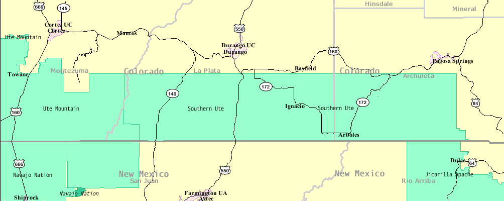
| Popis | A map of the Southern Ute Reservation |
| Dátum | |
| Zdroj | U.S. Census Bureau: American FactFinder, a combination of two maps |
| Autor | U.S. Census Bureau |
Source maps: [1][dead link][2][dead link]
Licencovanie
Toto dílo je ve Spojených státech volným dílem, protože jde o dílo úřadů americké federální vlády podle ustanovení Hlavy 17, Kapitoly 1, Sekce 105 amerického právního řádu. Viz Autorské právo.
Upozornění: uvedené se vztahuje pouze na díla úřadů federální vlády, nikoliv na úřady jednotlivých států, okresů, či nižších územně správních jednotek.
|
 | |
| Tento súbor bol identifikovaný, že nemá žiadne známe obmedzenia vyplývajúce z autorského zákona vrátane všetkých súvisiacich a susedných práv. | ||
História súboru
Po kliknutí na dátum/čas uvidíte ako súbor vyzeral vtedy.
| Dátum/Čas | Náhľad | Rozmery | Používateľ | Komentár | |
|---|---|---|---|---|---|
| aktuálna | 12:24, 7. december 2015 | 1 004 × 400 (20 KB) | GregorB | Reverted, does not need to be rotated | |
| 01:00, 4. december 2015 | 400 × 1 004 (24 KB) | SteinsplitterBot | Bot: Image rotated by 90° | ||
| 20:24, 18. november 2007 | 1 004 × 400 (20 KB) | Ken g6 | {{Information |Description=A map of the Southern Ute Reservation |Source=U.S. Census Bureau: American FactFinder, a combination of two maps ([http://factfinder.census.gov/servlet/ReferenceMapFramesetServlet?_bm=y&-_pa |
Použitie súboru
Žiadne stránky neobsahujú odkazy na tento súbor.
Globálne využitie súborov
Nasledovné ďalšie wiki používajú tento súbor:
- Použitie na ar.wikipedia.org
- Použitie na ca.wikipedia.org
- Použitie na en.wikipedia.org
- Použitie na ja.wikipedia.org
- Použitie na ru.wikipedia.org