
Súbor:Tibet Karte Topograpisch.png
Veľkosť tohto náhľadu: 800 × 540 pixelov. Iné rozlíšenia: 320 × 216 pixelov | 640 × 432 pixelov | 1 024 × 691 pixelov | 1 500 × 1 012 pixelov .
Pôvodný súbor (1 500 × 1 012 pixelov, veľkosť súboru: 3,08 MB, MIME typ: image/png)
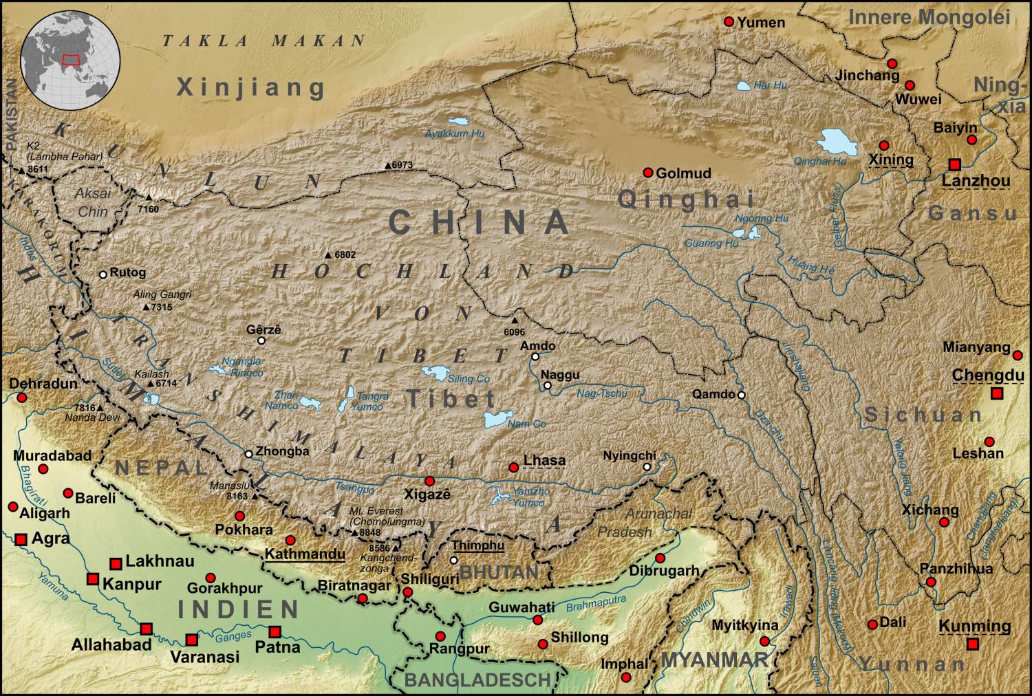
| Popis | Topographische Karte der chinesischen autonomen Provinz Tibet, sowie der umliegenden chinesischen Provinzen und der angrenzenden Länder |
| Dátum | |
| Zdroj |
own work, used:
|
| Autor | Lencer |
| Ďalšie verzie | Derivative works of this file: ZabuyeLake1.png |
Tento súbor podlieha licencii Creative Commons Attribution-Share Alike 3.0 Unported
- Môžete slobodne:
- zdieľať – kopírovať, šíriť a prenášať dielo
- meniť ho – upravovať dielo
- Za nasledovných podmienok:
- uvedenie autorov – Musíte spomenúť autorov (jednotlivo alebo kolektívne), poskytnúť odkaz na licenciu a uviesť, či ste niečo zmenili. Môžete to urobiť ľubovoľným primeraným spôsobom, ale nie spôsobom naznačujúcim, že poskytovateľ licencie podporuje vás alebo vaše použitie diela.
- meniť za rovnakých podmienok – Ak toto dielo zmeníte, prevediete do inej formy alebo použijete ako základ iného diela, musíte výsledok šíriť pod rovnakou alebo kompatibilnou licenciou ako originál.

|
Tato mapa byla vytvořena nebo vylepšena v německé Kartenwerkstatt (Mapová laboratoř). Můžete také navrhnout mapy k vylepšení.
|
História súboru
Po kliknutí na dátum/čas uvidíte ako súbor vyzeral vtedy.
| Dátum/Čas | Náhľad | Rozmery | Používateľ | Komentár | |
|---|---|---|---|---|---|
| aktuálna | 06:30, 28. október 2015 | | 1 500 × 1 012 (3,08 MB) | Lencer | Ulugh Muztagh now 6973 m |
| 06:30, 28. október 2015 |  | 3 240 × 2 185 (12,63 MB) | Lencer | Ulugh Muztagh now 6973 m | |
| 13:11, 1. marec 2009 |  | 1 500 × 1 012 (3,11 MB) | Lencer | Einige Korrekturen und Ergänzungen | |
| 21:22, 12. december 2008 |  | 1 500 × 1 012 (3,11 MB) | Lencer | {{Information |Description= |Source= |Date= |Author= |Permission= |other_versions= }} | |
| 08:18, 12. december 2008 |  | 1 500 × 1 012 (3,11 MB) | Lencer | {{Information |Description= |Source= |Date= |Author= |Permission= |other_versions= }} | |
| 12:57, 11. december 2008 |  | 1 500 × 1 012 (3,11 MB) | Lencer | {{Information |Description= |Source= |Date= |Author= |Permission= |other_versions= }} | |
| 12:13, 22. november 2008 |  | 1 500 × 1 012 (3,1 MB) | Lencer | {{Information |Description= |Source= |Date= |Author= |Permission= |other_versions= }} | |
| 14:46, 16. november 2008 |  | 1 500 × 1 012 (3,09 MB) | Lencer | {{Information| |Description=Topograhische Karte der chinesischen autonomen Provinz Tibet, sowie der umliegenden chinesischen Provinzen und der angrenzenden Länder |Source=own work, used: * Generic Mapping Tools and SRTM30-fi |
Použitie súboru
Na tento súbor odkazuje nasledujúca stránka:
Globálne využitie súborov
Nasledovné ďalšie wiki používajú tento súbor:
- Použitie na af.wikipedia.org
- Použitie na ar.wikipedia.org
- Použitie na ast.wikipedia.org
- Použitie na az.wikipedia.org
- Použitie na bo.wikipedia.org
- Použitie na ca.wikipedia.org
- Použitie na ceb.wikipedia.org
- Použitie na ckb.wikipedia.org
- Použitie na de.wikipedia.org
- Kunlun
- Transhimalaya
- Autonomes Gebiet Tibet
- Diskussion:Karakorum (Gebirge)
- Hochland von Tibet
- Benutzer:Lencer
- Benutzer:Lencer/Galerie
- Wikipedia:Kartenwerkstatt/Archiv/2008-12
- Diskussion:Transhimalaya
- Wikipedia Diskussion:Hauptseite/Artikel des Tages/Archiv/Vorschläge/2013/Q1
- Wikipedia:Hauptseite/Archiv/14. Februar 2013
- Tibet (1912–1951)
- Pinjarra-Orogen
- Tektonische Entwicklung des indischen Subkontinents
- Geologie des Transhimalayas
- Geologie der Indus-Yarlung suture zone
- Použitie na el.wikipedia.org
- Použitie na en.wikipedia.org
- Použitie na eo.wikipedia.org
- Použitie na es.wikipedia.org
- Použitie na eu.wikipedia.org
- Použitie na fi.wikipedia.org
- Použitie na frr.wikipedia.org
- Použitie na fr.wikipedia.org
- Použitie na ga.wikipedia.org
- Použitie na gl.wikipedia.org
- Použitie na he.wikivoyage.org
- Použitie na hi.wikipedia.org
- Použitie na hu.wikipedia.org
- Použitie na hy.wikipedia.org
- Použitie na it.wikipedia.org
- Použitie na ja.wikipedia.org
- Použitie na ku.wikipedia.org
- Použitie na lld.wikipedia.org
Zobraziť ďalšie globálne použitie tohto súboru.