
Súbor:Cayman Islands location map.svg

Veľkosť tohoto PNG náhľadu tohoto SVG súboru: 799 × 319 pixelov. Iné rozlíšenia: 320 × 128 pixelov | 640 × 256 pixelov | 1 024 × 409 pixelov | 1 280 × 511 pixelov | 2 560 × 1 022 pixelov | 924 × 369 pixelov .
Pôvodný súbor (SVG súbor, 924 × 369 pixelov, veľkosť súboru: 33 KB)
| Popis |
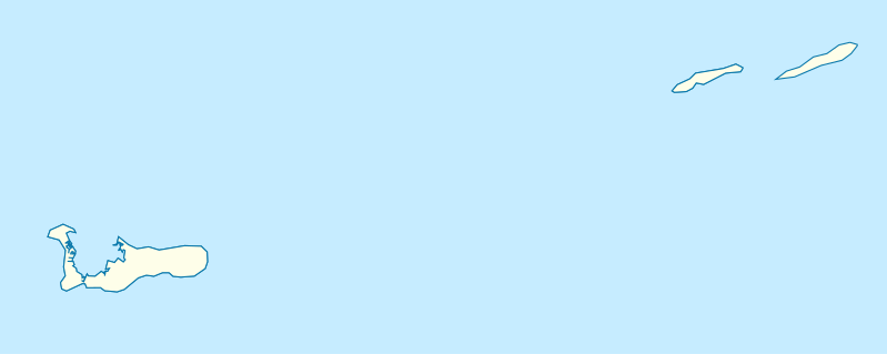
Deutsch: Positionskarte der Kaimaninseln. Geographische Begrenzungen der Karte:
English: Location map of the Cayman Islands. Geographic limits of the map:
|
| Dátum | |
| Zdroj | Vlastné dielo, using OpenStreetMap Data for the coastlines |
| Autor |
Graphic made by Carport |
Licencovanie
Tento súbor podlieha licencii Creative Commons Attribution-Share Alike 2.0 Generic
- Môžete slobodne:
- zdieľať – kopírovať, šíriť a prenášať dielo
- meniť ho – upravovať dielo
- Za nasledovných podmienok:
- uvedenie autorov – Musíte spomenúť autorov (jednotlivo alebo kolektívne), poskytnúť odkaz na licenciu a uviesť, či ste niečo zmenili. Môžete to urobiť ľubovoľným primeraným spôsobom, ale nie spôsobom naznačujúcim, že poskytovateľ licencie podporuje vás alebo vaše použitie diela.
- meniť za rovnakých podmienok – Ak toto dielo zmeníte, prevediete do inej formy alebo použijete ako základ iného diela, musíte výsledok šíriť pod rovnakou alebo kompatibilnou licenciou ako originál.
História súboru
Po kliknutí na dátum/čas uvidíte ako súbor vyzeral vtedy.
| Dátum/Čas | Náhľad | Rozmery | Používateľ | Komentár | |
|---|---|---|---|---|---|
| aktuálna | 17:07, 23. november 2009 | 924 × 369 (33 KB) | Carport | {{Information |Description={{de|1=Positionskarte der {{w|Kaimaninseln|3=de}}. Geographische Begrenzungen der Karte: * N: 19.84° N * S: 19.14° N * W: 81.52° W * E: 79.66° W}} {{en|1=Location map of the {{w|Cayman Islands}}. Geographic limits of the ma |
Použitie súboru
Na tento súbor odkazujú nasledujúce 2 stránky:
Globálne využitie súborov
Nasledovné ďalšie wiki používajú tento súbor:
- Použitie na af.wikipedia.org
- Použitie na an.wikipedia.org
- Použitie na ar.wikipedia.org
- Použitie na ast.wikipedia.org
- Použitie na ba.wikipedia.org
- Použitie na be.wikipedia.org
- Použitie na bg.wikipedia.org
- Použitie na ceb.wikipedia.org
- Plantilya:Location map United Kingdom Cayman Islands
- Welch Point
- South Channel
- Palmetto Point
- The Narrows
- Crawl Bay
- Sandy Point
- East Point
- West Bay
- Long Point
- Low Point
- South West Point
- George Town
- Charles Bay
- West End Point
- West End
- Water Cay
- Southwest Point
- Gun Bluff
- Cedar Point
- The Bight
- North Side
- East End
- Eden Rocks
- Prospect Point
- Stake Bay
- Little Sound
- Main Channel
- Rum Point
- Sand Cay
- East Channel
- North Reef
- Boatswain Point
- Beach Point
- Owen Island
Zobraziť ďalšie globálne použitie tohto súboru.