
Súbor:IBEX all sky map.jpg

Veľkosť tohto náhľadu: 800 × 450 pixelov. Iné rozlíšenia: 320 × 180 pixelov | 640 × 360 pixelov | 1 024 × 576 pixelov | 1 280 × 720 pixelov | 2 560 × 1 440 pixelov .
Pôvodný súbor (2 560 × 1 440 pixelov, veľkosť súboru: 523 KB, MIME typ: image/jpeg)
Zhrnutie
| Popis |
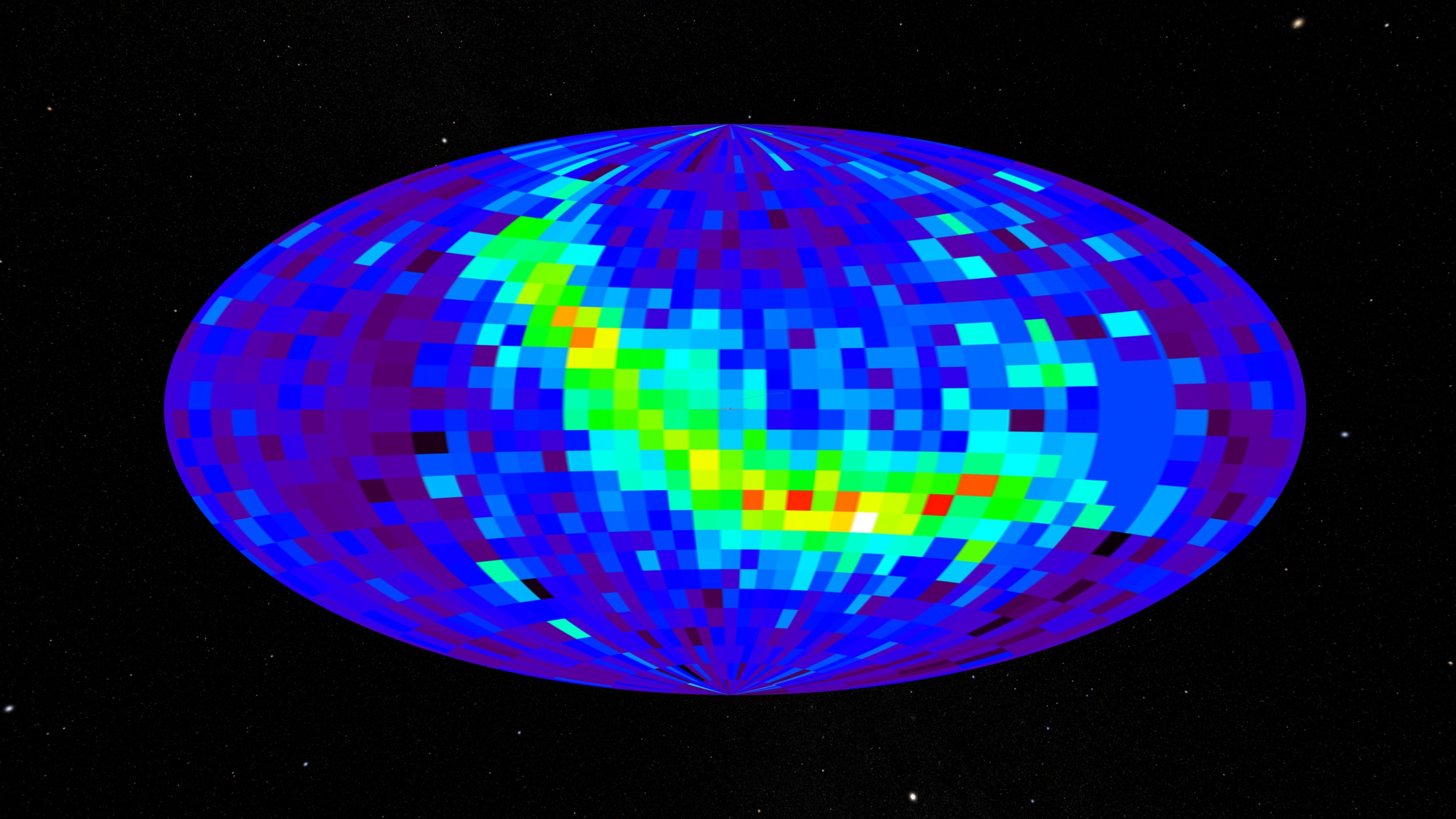
English: All-sky map created using the IBEX spacecraft. This data comes from the IBEX-Hi instrument showing differential flux at 0.9-1.5 keV. |
| Dátum | (released) |
| Zdroj | https://svs.gsfc.nasa.gov/3635 (image link) |
| Autor | NASA/Goddard Space Flight Center Scientific Visualization Studio/Tom Bridgman |
Licencovanie
| This file is in the public domain in the United States because it was solely created by NASA. NASA copyright policy states that "NASA material is not protected by copyright unless noted". (See Template:PD-USGov, NASA copyright policy page or JPL Image Use Policy.) | ||
 |
Warnings:
|
História súboru
Po kliknutí na dátum/čas uvidíte ako súbor vyzeral vtedy.
| Dátum/Čas | Náhľad | Rozmery | Používateľ | Komentár | |
|---|---|---|---|---|---|
| aktuálna | 06:30, 17. máj 2018 | | 2 560 × 1 440 (523 KB) | Huntster | Full resolution. |
| 00:05, 17. október 2009 |  | 320 × 180 (41 KB) | Vanished user 392817 | {{Information |Description={{en|1=All sky map created using IBEX satellite. When using please give credit to NASA/Goddard Space Flight Center Scientific Visualization Studio.}} |Source=NASA |Author=NASA/Goddard Space Flight Center Scientific Visualization |
Použitie súboru
Na tento súbor odkazuje nasledujúca stránka:
Globálne využitie súborov
Nasledovné ďalšie wiki používajú tento súbor:
- Použitie na ca.wikipedia.org
- Použitie na cs.wikipedia.org
- Použitie na en.wikipedia.org
- Použitie na en.wikinews.org
- Použitie na fa.wikipedia.org
- Použitie na fa.wikibooks.org
- Použitie na ja.wikipedia.org
- Použitie na ka.wikipedia.org
- Použitie na mk.wikipedia.org
- Použitie na ml.wikipedia.org
- Použitie na ms.wikipedia.org
- Použitie na pl.wikinews.org
- Použitie na pt.wikipedia.org
- Použitie na ro.wikipedia.org
- Použitie na ru.wikipedia.org
- Použitie na sl.wikipedia.org
- Použitie na tr.wikipedia.org
- Použitie na zh.wikipedia.org