
Súbor:Newark buses.svg

Veľkosť tohoto PNG náhľadu tohoto SVG súboru: 585 × 599 pixelov. Iné rozlíšenia: 234 × 240 pixelov | 469 × 480 pixelov | 750 × 768 pixelov | 1 000 × 1 024 pixelov | 1 999 × 2 048 pixelov | 4 452 × 4 560 pixelov .
Pôvodný súbor (SVG súbor, 4 452 × 4 560 pixelov, veľkosť súboru: 1,24 MB)
Zhrnutie
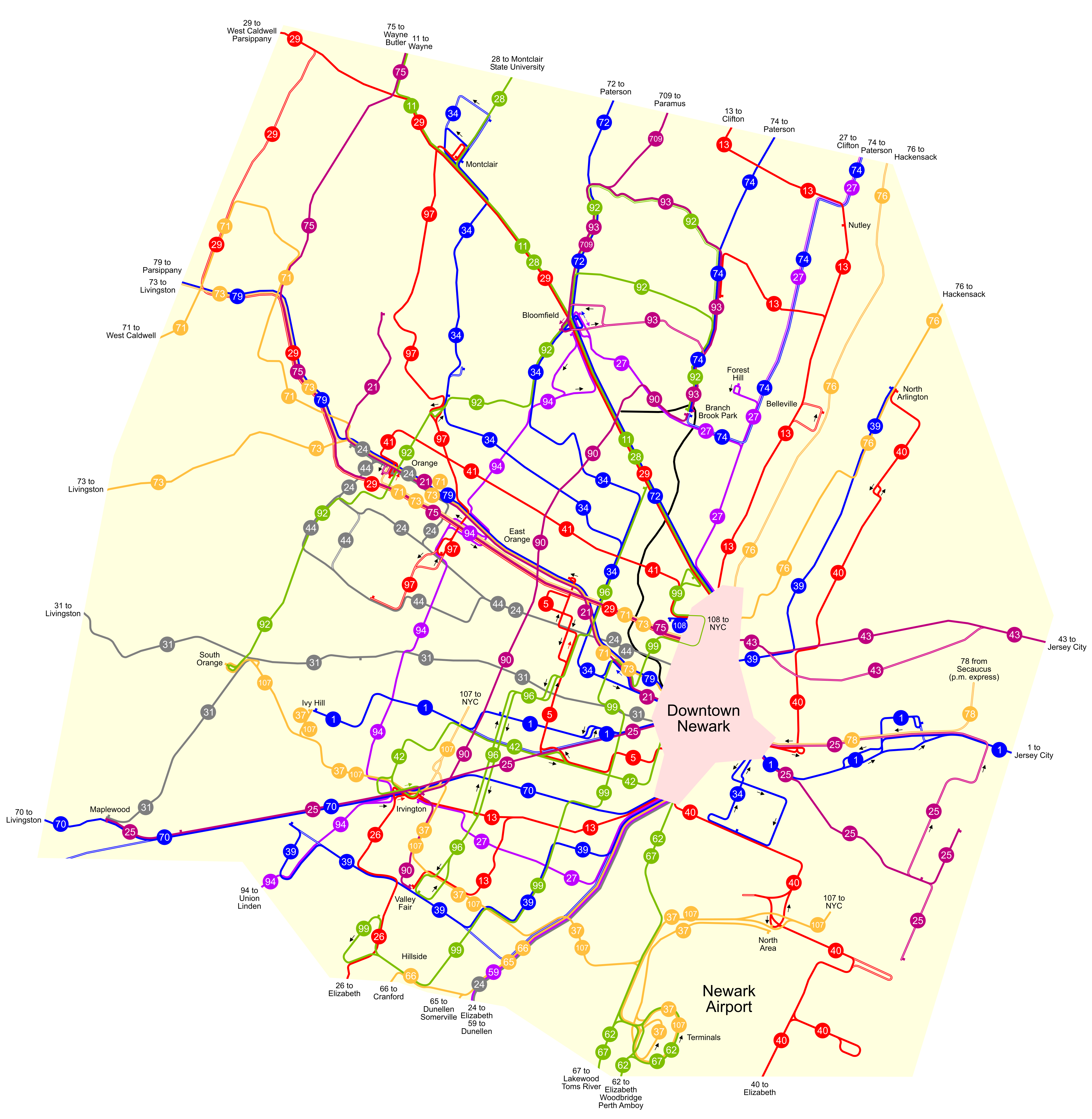
| Popis | A map of the public bus routes in and around Newark, New Jersey, United States. The projection is Lambert conformal conic with a central meridian of 74.45 degrees west. The boundaries were arbitrarily chosen as places where the route density thins out. |
| Dátum | |
| Zdroj | Vlastné dielo |
| Autor | User:NE2 |
Licencovanie
| Ja, držiteľ autorských práv k tomuto dielu, uvoľňujem toto dielo ako voľné dielo (public domain). Toto platí celosvetovo. V niektorých krajinách to zákon neumožňuje; v tom prípade: Udeľujem komukoľvek právo používať toto dielo na ľubovoľné účely, bez akýchkoľvek podmienok ak také podmienky nevyžaduje zákon. |
História súboru
Po kliknutí na dátum/čas uvidíte ako súbor vyzeral vtedy.
| Dátum/Čas | Náhľad | Rozmery | Používateľ | Komentár | |
|---|---|---|---|---|---|
| aktuálna | 21:35, 31. január 2007 | | 4 452 × 4 560 (1,24 MB) | NE2 | Added the 24, 31, and 44. |
| 18:54, 30. január 2007 |  | 4 452 × 4 560 (1,18 MB) | NE2 | De-emphasized the boundaries and enlarged it even more (3200%). | |
| 16:44, 30. január 2007 |  | 1 113 × 1 140 (1,17 MB) | NE2 | Enlarged by 800%. | |
| 16:33, 30. január 2007 |  | 139 × 143 (1,18 MB) | NE2 | This is the first draft of a map of the public bus routes in and around Newark, New Jersey, United States. You'll have to use an SVG viewer to see it full-size until I make a large raster image. The projection is Lambert conformal conic with a central me |
Použitie súboru
Žiadne stránky neobsahujú odkazy na tento súbor.
Globálne využitie súborov
Nasledovné ďalšie wiki používajú tento súbor:
- Použitie na bn.wikibooks.org
- Použitie na en.wikipedia.org
- Použitie na en.wikibooks.org