
Súbor:Storm in Bagram.jpg

Pôvodný súbor (1 024 × 633 pixelov, veľkosť súboru: 260 KB, MIME typ: image/jpeg)
Zhrnutie
| Popis |
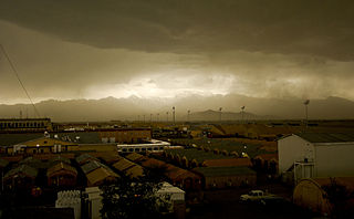
A storm rolls into Bagram Air Field, Afghanistan, April 20. The 455th Expeditionary Operations Support Squadron, combat weather team, uses a variety of techniques to predict weather. They use of a Mark IV satellite and visual reference to determine type and severity of storm to better prepare personnel on BAF to maintain mission effectiveness. Rainstorms are frequent this time of year and have the ability to change the landscape to include rivers and streams. With the lack of drainage systems, floods occur regularly throughout the southeast region of Afghanistan. Precipitation in east and southeast regions is about forty centimeters per year. 455th Air Expeditionary Wing Photo by Senior Airman Erik Cardenas Date: 04.20.2009 Location: BAGRAM AIR FIELD, AF Related photos: dvidshub.net/r/zk92xz |
| Dátum | Fotené: 20. apríla 2009, 15:29 |
| Zdroj | Storm in Bagram |
| Autor | DVIDSHUB |
Licencovanie
- Môžete slobodne:
- zdieľať – kopírovať, šíriť a prenášať dielo
- meniť ho – upravovať dielo
- Za nasledovných podmienok:
- uvedenie autorov – Musíte spomenúť autorov (jednotlivo alebo kolektívne), poskytnúť odkaz na licenciu a uviesť, či ste niečo zmenili. Môžete to urobiť ľubovoľným primeraným spôsobom, ale nie spôsobom naznačujúcim, že poskytovateľ licencie podporuje vás alebo vaše použitie diela.
| This image was originally posted to Flickr by DVIDSHUB at https://www.flickr.com/photos/28650594@N03/3483547353. It was reviewed on 18. mája 2009 by FlickreviewR and was confirmed to be licensed under the terms of the cc-by-2.0. |
História súboru
Po kliknutí na dátum/čas uvidíte ako súbor vyzeral vtedy.
| Dátum/Čas | Náhľad | Rozmery | Používateľ | Komentár | |
|---|---|---|---|---|---|
| aktuálna | 20:49, 17. máj 2009 | | 1 024 × 633 (260 KB) | Geo Swan | {{Information |Description= A storm rolls into Bagram Air Field, Afghanistan, April 20. The 455th Expeditionary Operations Support Squadron, combat weather team, uses a variety of techniques to predict weather. They use of a Mark IV satellite and visual r |
Použitie súboru
Na tento súbor odkazuje nasledujúca stránka:
Globálne využitie súborov
Nasledovné ďalšie wiki používajú tento súbor:
- Použitie na cs.wikipedia.org