
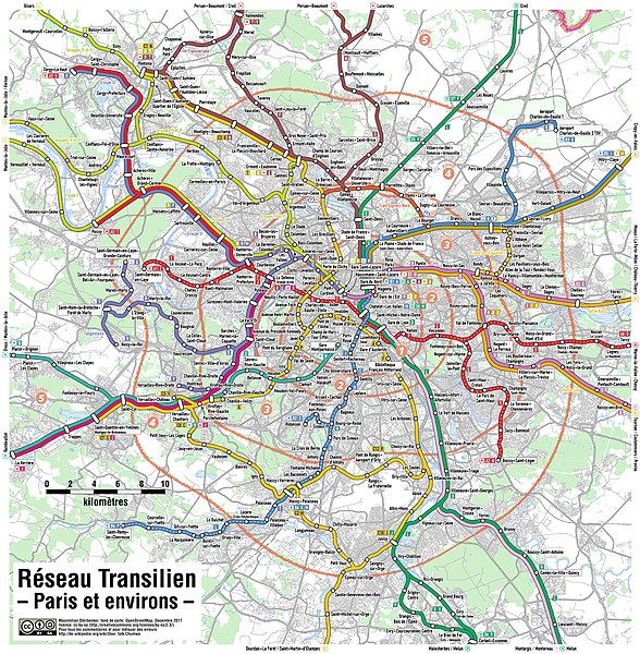
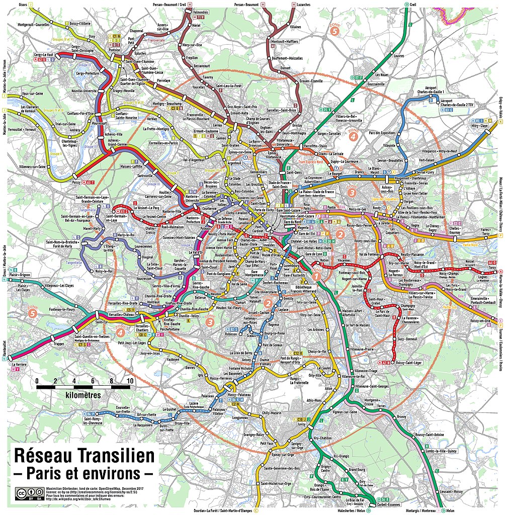
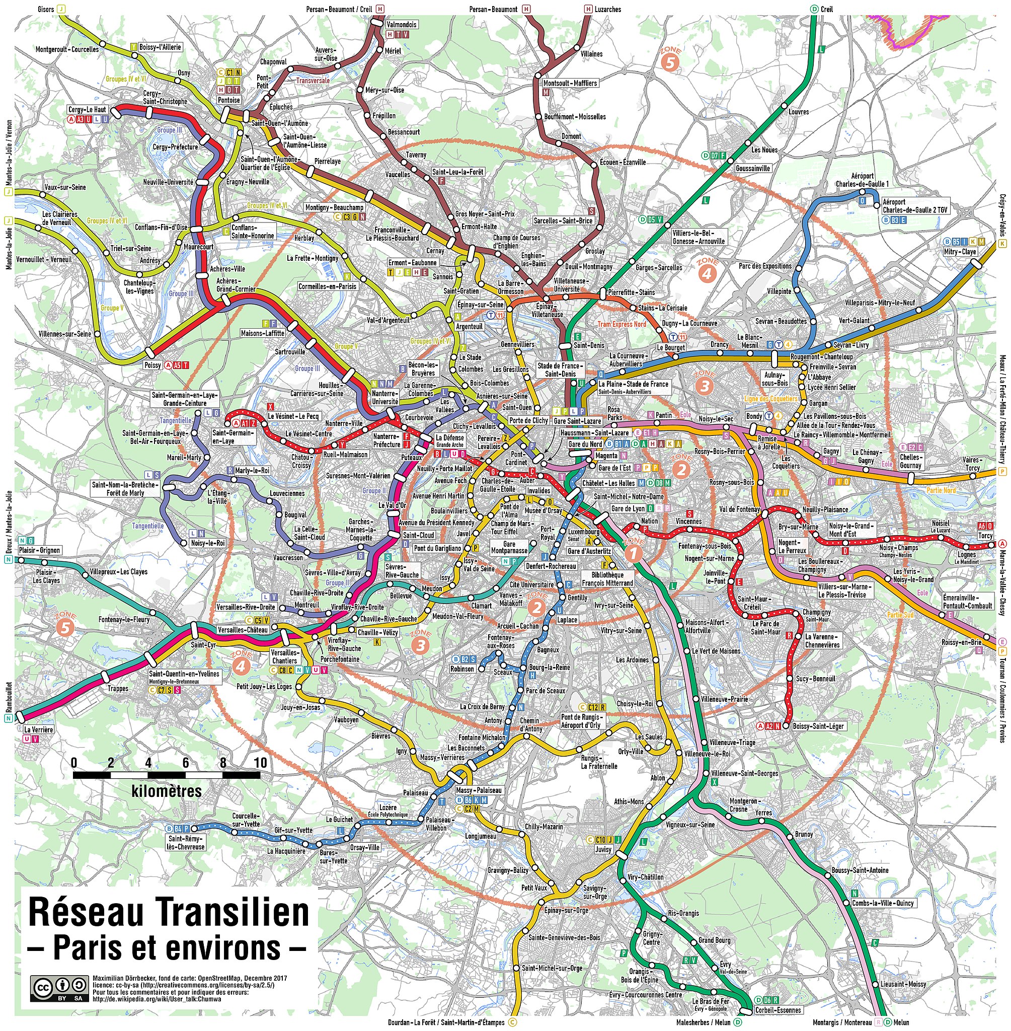
Súbor:Transilien Paris region map.jpg

Veľkosť tohto náhľadu: 588 × 600 pixelov. Iné rozlíšenia: 235 × 240 pixelov | 471 × 480 pixelov | 753 × 768 pixelov | 1 004 × 1 024 pixelov | 2 009 × 2 048 pixelov | 3 109 × 3 170 pixelov .
Pôvodný súbor (3 109 × 3 170 pixelov, veľkosť súboru: 8,54 MB, MIME typ: image/jpeg)

|
Tento obrázek (skupina transport map) by měl být vytvořen pomocí vektorové grafiky jako SVG soubor. To má několik výhod; podrobnosti najdete na stránce Commons:Media for cleanup. Je-li SVG verze tohoto obrázku již k dispozici, prosím nahrajte ji. Po nahrání nahraďte tuto šablonu šablonou {{Vector version available|jméno nového obrázku.svg}}.
|


| Popis |
|
| Dátum | see file history |
| Zdroj | Vlastné dielo, using OpenStreetMap data for the background |
| Autor | Maximilian Dörrbecker (Chumwa) |
| Povolenie (Využívanie tohto súboru) |
All OpenStreetMap data and maps are Creative Commons "CC-BY-SA 2.0" licensed Tento súbor podlieha licencii Creative Commons Attribution-Share Alike 2.0 Generic
|
| Ďalšie verzie |
|


História súboru
Po kliknutí na dátum/čas uvidíte ako súbor vyzeral vtedy.
| Dátum/Čas | Náhľad | Rozmery | Používateľ | Komentár | |
|---|---|---|---|---|---|
| aktuálna | 19:07, 25. december 2017 | | 3 109 × 3 170 (8,54 MB) | Chumwa | Kartenrahmen vergessen |
| 18:56, 25. december 2017 |  | 3 109 × 3 170 (8,82 MB) | Chumwa | + T11 Express | |
| 17:28, 14. december 2015 |  | 3 109 × 3 170 (7,16 MB) | Chumwa | + Rosa Parks | |
| 22:24, 10. december 2012 |  | 3 109 × 3 170 (2,25 MB) | Chumwa | {{Information |Description= *{{ de }} Karte des Transilien-Netzes in der Region Paris. Eine deteillierte Kartenlegende findet sich hier. *{{ en }} Map of the Transilien network in the Paris region. A detaile... |
Použitie súboru
Na tento súbor odkazuje nasledujúca stránka:
Globálne využitie súborov
Nasledovné ďalšie wiki používajú tento súbor:
- Použitie na cs.wikipedia.org
- Použitie na de.wikipedia.org
- Použitie na en.wikipedia.org
- Použitie na eo.wikipedia.org
- Použitie na es.wikipedia.org
- Použitie na fi.wikipedia.org
- Použitie na fr.wikipedia.org
- Použitie na it.wikipedia.org
- Použitie na ko.wikipedia.org