Súbor:Europe map 1919.jpg
Obsah stránky není podporován v jiných jazycích.
z Wikipédie, slobodnej encyklopédie

Pôvodný súbor(1 920 × 1 440 pixelov, veľkosť súboru: 1,41 MB, MIME typ: image/jpeg)

Tento zdieľaný súbor je z Wikimedia Commons a je možné ho používať na iných projektoch. Nižšie sú zobrazené informácie z popisnej stránky súboru.

Zhrnutie

Popis
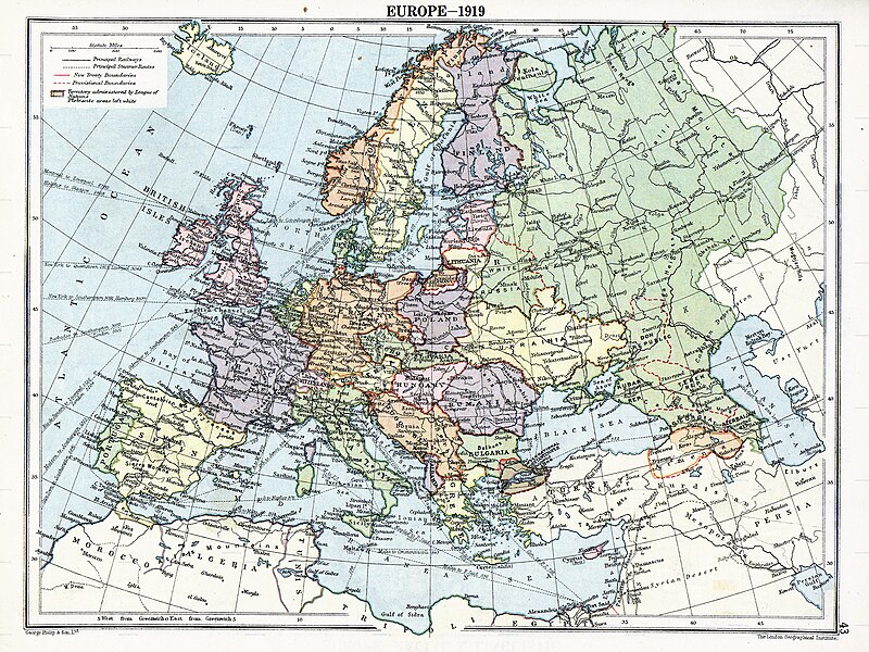
English: Map of en:Europe political divisions in 1919 (after the treaties of Brest-Litovsk and Versailles and before the treaties of Trianon, Riga, Kars and the establishment of en:Soviet Union and the republics of Ireland and Turkey) published by London Geographical Institute. This uploaded map is a photoshopped version of the original image located at hipkiss.org. According to the site, there are no copyrights to this map.
Zdroj
Autor
Ďalšie verzie Derivative works of this file:  Europe map 1919 cropped.JPG
Maps of the history of Europe
BCE
aC

Weichselian ice age (c. 113,000–9700) · Neolithic expansion (c. 7000–4500) · Middle Neolithic (c. 4500–4000) · Late Neolithic (c. 4000–3000) · Copper Age – Corded Ware culture (c. 2900–2350) · Copper Age – Bellbeaker culture (c. 2800–1800) · Early Bronze Age – Unetice culture (c. 2300–1600) · Late Bronze Age – Urnfield culture (c. 1300—750) · Migrations (c. 1000–100) · Hallstatt & La Tène cultures (c. 800–100) · Roman Republic (510–40) · 220 · 218 · 200 · 201–100 · 58 · 49 · 39 · 30 BCE–6 CE


CE
dC

14 · 14–37 · 60 · 60 · 69 · 80 · Migrations 100–500 · 117 · 117 · 125 · Migrations 150–774 · Economy 180 · 271 · 293–305 · 337 · 395 · c. 395 · 400 · 400 · 450 · 457–61 · 476 · 480 · Franks 481–814 · Early Slavs 500–700 · 500 · 526 · 526–600 · Christianisation to 600 · c. 550 · 650 · Pontic Steppe 650 · 665 · 800 · Vikings 800–1050 · 814 · 843–70 · 850 · 900 · 912 · 998 · 1000 · 1000 · 1054 · 1092 · First Crusade 1095–99 · 1097 · 1135 · 1142 · 1147–49 · 1190 · 1190 · 1250 · c. 1250 · 1301-1400 · 1301-1400 · 1328 · 1345 · Black Plague 1347–51 · 1360 · 1400 · Trade routes c. 1400 · 1430 · 1470 · 1490 · 1492 · 1500 · 1519 · 1550 · 1560 · Religion 1560 · Religion 1600 · Religion 1618 · 1618–48 · 1648 · 1683 · 1700 · 1701 · 1708 · 1714 · 1721 · 1725–30 · 1739–1740 · 1740 · 1748–66 · 1783–1792 · 1787 · 1787 · 1789 · 1799 · 1812 · 1812 · 1812 · 1812 · 1813 · 1815 · 1815 · 1815 · 1818 · Ottoman Empire 1830–1923 · 1848–49 · 1861 · 1867 · 1871 · 1878 · 1890 · 1905 · 1911 · 1914 · 1914 · 1919 · 1919–29 · 1923 · 1929 · 1930 · 1940 · 1941–42 · 1942–45 · Cold War 1947–91 · 1950 · 1993–2006 · 2006 to date

(this template: · view · discuss )

Licencovanie

Public domain
Public domain
Toto dílo je ve Spojených státech volným dílem. To platí pro americká díla, jejichž autorská práva vypršela, často proto, že byla poprvé zveřejněna před 1. lednem 1929. Podívejte se na tuto stránku pro další vysvětlení.

United States
United States
Tento obrázek nemusí být volným dílem mimo Spojené státy; to se týká zvláště těch zemí a oblastí, kde pro americká díla neplatí pravidlo kratší doby, jako jsou Kanada, Kontinentální Čína (ne Hong Kong nebo Macao), Německo, Mexiko a Švýcarsko. Tvůrce a rok publikace jsou nezbytné informace a musí být uvedeny. Viz Wikipedie:Autorské právo pro více informací.

Pôvodný záznam nahrávaní

The original description page was here. All following user names refer to en.wikipedia.
  • 2007-11-03 20:09 MaGioZal 1996×1506×8 (1457003 bytes) Map of [[Europe]] political divisions in 1919 (after the treaties of [[Treaty_of_Brest-Litovsk|Brest-Livotsk]] and [[Treaty of Versailles|Versailles]] and before the [[Treaty of Riga]] and the creation of [[Soviet Union]]) published by London Geographical

Štítky

Pridajte jednoriadkové vysvetlenie, čo tento súbor predstavuje
The situation in Europe after WW1. Several new states were born such as Ukraine(the country in Yellow at the North of the Black Sea)

Položky prezentované týmto súborom

motív

image/jpeg

História súboru

Po kliknutí na dátum/čas uvidíte ako súbor vyzeral vtedy.

Dátum/ČasNáhľadRozmeryPoužívateľKomentár
aktuálna05:41, 7. august 2023Náhľad verzie z 05:41, 7. august 20231 920 × 1 440 (1,41 MB)User-duckCropped to reduce border using CropTool with lossless mode.
23:29, 22. apríl 2008Náhľad verzie z 23:29, 22. apríl 20081 996 × 1 506 (1,39 MB)File Upload Bot (Magnus Manske) {{BotMoveToCommons|en.wikipedia}} {{Information |Description={{en|Map of en:Europe political divisions in 1919 (after the treaties of Brest-Livotsk and Versailles and before the treaties o

Na tento súbor odkazuje nasledujúca stránka:

Globálne využitie súborov

Nasledovné ďalšie wiki používajú tento súbor:

Zobraziť ďalšie globálne použitie tohto súboru.