
Súbor:First Composite Image of the Global Biosphere - GPN-2003-00027.jpg

Veľkosť tohto náhľadu: 800 × 406 pixelov. Iné rozlíšenia: 320 × 162 pixelov | 640 × 325 pixelov | 1 024 × 520 pixelov | 1 280 × 650 pixelov | 3 000 × 1 523 pixelov .
Pôvodný súbor (3 000 × 1 523 pixelov, veľkosť súboru: 2,94 MB, MIME typ: image/jpeg)
| Popis |
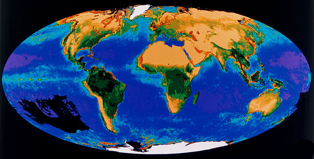
English: This first image of the global biosphere which was produced by combining data from two different satellite sensors show for the first time the productive potential of the Earth's vegetative biomass. The ocean image is a composite of all data collected during the 20-month period from November 1978 through June 1980 by the Coastal Zone Color Scanner (CZCS) flown on NASA's Nimbus-7 satellite, managed by the Goddard Space Flight Center, Greenbelt, Maryland. The CZCS data show concentrations of marine phytoplankton pigment. Phytoplanktons, the microscopic plants that grow in the sunlight regions of the ocean, form the base of the marine food web. Red and orange colors indicate areas of high plankton concentrations. Yellow and green represent areas of moderate concentration. One of the most notable features in this image is the clear delineation of the equator through increased plant abundance, and the differences between the equatorial Atlantic, Indian, and Pacific Oceans. Plankton concentrations tend to be high nutrients to the sunlit upper ocean layers. Major areas of the South Pacific are blank (black areas=no data) because the CZCS could operate only intermittently. The land-vegetation image is a composite of three years of data from the Advanced Very High Resolution Radiometer (AVHRR) on the National Oceanographic and Atmospheric Agency (NOAA-7) satellite, which measured land-surface radiation in the visible and near-infrared bands to estimate chlorophyll and leaf potential for chlorophyll production. The lighter shades of green highlight tropical and subtropical forests, temperate forests and farmlands, and some drier regions such as savannas and pampas. The yellow shades in the United States Midwest show lower potential, while the darker yellow shades of Northern Hemisphere forests and the dry Australian Outback rank lower. Desert, high mountains, and arctic regions reflect barren conditions, intermittently. The land-vegetation image is a composite of three years of data from the Advanced Very High Resolution Radiometer (AVHRR) on the NOAA-7 satellite, which measures land-surface radiation in the visible and near-infrared bands to estimate chlorophyll and leaf mass. The dark green areas (rain forests) show the highest potential for chlorophyll production. The lighter shades of green highlight tropical and subtropical forests, temperate forests and farmlands and some drier regions such as savannas and pampas. The yellow shades in the United States Midwest show lower potential, while the darker yellow shade of Northern Hemisphere forests and the dry Australian Outback rank lower. Desserts, high mountains, and arctic regions reflect barren conditions. |
|||||
| Dátum | ||||||
| Zdroj | ||||||
| Autor | NASA | |||||
| Povolenie (Využívanie tohto súboru) |
|

Tento mediální soubor byl katalogizován v centrále NASA amerického Národního úřadu pro letectví a kosmonautiku (NASA)pod Photo ID: GPN-2003-00027 A Alternate ID: 89-HC-311. Toto oznámení nepopisuje autorskoprávní status tohoto souboru. Stále je vyžadován běžný popisek licence. Další informace najdete na Commons:Licencování. Jiné jazyky:
|
História súboru
Po kliknutí na dátum/čas uvidíte ako súbor vyzeral vtedy.
| Dátum/Čas | Náhľad | Rozmery | Používateľ | Komentár | |
|---|---|---|---|---|---|
| aktuálna | 09:27, 2. máj 2015 | | 3 000 × 1 523 (2,94 MB) | Jcpag2012 | crop |
| 00:14, 10. apríl 2009 |  | 3 000 × 2 400 (3,04 MB) | BotMultichillT | {{Information |Description={{en|1=This first image of the global biosphere which was produced by combining data from two different satellite sensors show for the first time the productive potential of the Earth's vegetative biomass. The ocean image is a c |
Použitie súboru
Na tento súbor odkazuje nasledujúca stránka:
Globálne využitie súborov
Nasledovné ďalšie wiki používajú tento súbor:
- Použitie na it.wikipedia.org